
Guyana is divided into 10 regions:

The Berbice River, located in eastern Guyana, is one of the country's major rivers. It rises in the highlands of the Rupununi region and flows northward for 595 kilometres (370 mi) through dense forests to the coastal plain. The river's tidal limit is between 160 and 320 km (99–199 mi) from the sea.

Mahaica-Berbice is a region of Guyana, bordering the Atlantic Ocean to the north, the region of East Berbice-Corentyne to the east, the region of Upper Demerara-Berbice to the south and the region of Demerara-Mahaica to the west.
Demerara-Mahaica is a region of Guyana, bordering the Atlantic Ocean to the north, the region of Mahaica-Berbice to the east, the region of Upper Demerara-Berbice to the south and the region of Essequibo Islands-West Demerara to the west.
Rosignol is a village on the west bank of the Berbice River in Mahaica-Berbice, Guyana.

Upper Demerara-Berbice is a region of Guyana, bordering the regions of Essequibo Islands-West Demerara, Demerara-Mahaica and Mahaica-Berbice to the north, the region of East Berbice-Corentyne to the east, and the regions of Potaro-Siparuni and Cuyuni-Mazaruni to the west.

The Canje River, located in northeastern Guyana, is the main tributary of the Berbice River. It runs roughly parallel to the Atlantic Ocean coast in East Berbice-Corentyne, region 6.
The Torani Canal in northeastern Guyana serves to move water from the Berbice River into the Canje River. It was to serve as irrigation for the sugar industry, and subsequently the rice industry.
The Mahaicony River is a small river in northern Guyana that drains into the Atlantic Ocean. Mahaicony village is found at the mouth of the river.
The Mahaica River is a small river in northern Guyana that drains into the Atlantic Ocean. The village of Mahaica is found at its mouth.
The Railways of Guyana comprised two public railways, the Demerara-Berbice Railway and the Demerara-Essequibo Railway. There are also several industrial railways mainly for the bauxite industry. The Demerara-Berbice Railway is the oldest in South America. None of the railways are in operation in the 21st century.
Esau and Jacob is a village in the Mahaica-Berbice Region of Guyana. One of the oldest villages on the Mahaicony River, Esau and Jacob was named by Dutch settlers after the pair of twins in the Bible.
Abary is a small community in the Mahaica-Berbice Region of Guyana, near the mouth of the Abary River, 43 miles (69 km) from Georgetown. Abary is known for the Abary Bridge located on the Main Highway. The bridge was originally a railway bridge with a very steep grade. The bridge was designed by Joseph Walter Holder who also built the Demerara Harbour Bridge.
There are several communities named Bush Lot in Guyana. This article covers four locations.

Rockstone is a village on the right bank of the Essequibo River in the Upper Demerara-Berbice Region of Guyana, altitude 6 metres. Rockstone is approximately 26 km west of Linden and is linked by road.
The Kako River is a river in the Cuyuni-Mazaruni region of Guyana and one of the largest tributaries of the Mazaruni River.
George Simon was a Guyanese Lokono Arawak artist and archaeologist. He was the founder and mentor of the Lokono Artists Group, a group of Lokono artists from Guyana, based primarily in his hometown of St. Cuthbert's Mission. Simon was widely regarded as one of the leading Guyanese artists of his generation, and his paintings are notable for their explorations of Amerindian culture and the Guyanese environment. He was also recognized for his achievements as an educator, his efforts to develop opportunities for Amerindian artists in Guyana, and for his work as an archaeologist.
St. Cuthbert's Mission is an Amerindian village on the Mahaica River in the Demerara-Mahaica region of Guyana. It comprises approximately 200 households. St. Cuthbert's is regarded by many people in Guyana as the "cultural capital" for Amerindians.
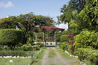
Guyana Botanical Gardens is a tropical botanical garden in Georgetown, Guyana. It is next to the Guyana Zoo and Castellani House.
Guyana National Park is an urban park in Georgetown, Guyana and was opened with Queen Elizabeth II in attendance and was formerly named Queen Elizabeth II National Park in honour of her state visit.
