Related Research Articles

The Branco River is the principal affluent of the Rio Negro from the north.
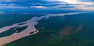
The Essequibo River is the largest river in Guyana, and the largest river between the Orinoco and Amazon. Rising in the Acarai Mountains near the Brazil–Guyana border, the Essequibo flows to the north for 1,014 km (630 mi) through forest and savanna into the Atlantic Ocean. It has a total drainage basin of 156,828 km2 (60,552 sq mi) and an average discharge of 5,650 m3/s (200,000 cu ft/s).
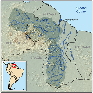
The Rupununi is a region in the south-west of Guyana, bordering the Brazilian Amazon. The Rupununi river, also known by the local indigenous peoples as Raponani, flows through the Rupununi region. The name Rupununi originates from the word rapon in the Makushi language, in which it means the black-bellied whistling duck found along the river.
Apoteri is a village in the Upper Takutu-Upper Essequibo Region of Guyana, near the confluence of the Rupununi River with the Essequibo, at an altitude of 53 metres. Apoteri started to develop as the centre of the balatá industry. The population is mainly Amerindian of the Macushi and Wapishana people.

The Takutu River is a river in the Upper Takutu-Upper Essequibo Region of Guyana and Roraima in Brazil. It forms part of the boundary between the two countries. The confluence of the Takutu and Uraricoera Rivers forms the Branco River. The Takutu River's sources almost link with those of the Essequibo River; in the rainy season, flooding links the Takutu to the Rupununi River, a tributary of the Essequibo.
The Siparuni River is a river in the Potaro-Siparuni Region of Guyana. It is a tributary of the Essequibo River. Tributaries of the Siparuni River include the Takutu River, Burro-Burro River, Tipuru River and Levai Creek.
Aishalton is an Amerindian village that is situated in the Rupununi savannah of southern Guyana, in the Upper Takutu-Upper Essequibo Region of the country.
The Kassikaityu River is a tributary of the Essequibo River of Guyana.
The Kuyuwini River is a river Guyana.
Fairview (Kurupukari) is an indigenous settlement on the Essequibo River, in the Upper Demerara-Berbice region of Guyana. It is the entry point to the Iwokrama Forest. Former president David A. Granger once referred to Iwokrama as the "green heart of Guyana."

Sydney Charles Allicock is a Guyanese politician. He was minister of Indigenous People's Affairs in Guyana from 2015-2020, and was vice-president of Guyana from 2015-2020.
Rewa is an Amerindian village in the Upper Takutu-Upper Essequibo region of Guyana.

Yupukari is an indigenous village of Macushi and Wapishana Amerindians in the Upper Takutu-Upper Essequibo Region of Guyana. It is located between the Kanuku and Pakaraima Mountains along the Rupununi River.
St. Ignatius is an Amerindian village in the Upper Takutu-Upper Essequibo region of Guyana, near the regional capital Lethem and the border of Brazil. It was originally a mission founded by Jesuit priests to serve the Amerindians in the Rupununi savannah.
Karaudarnau is an indigenous village of Wapishana Amerindians in the Upper Takutu-Upper Essequibo Region of Guyana. It is located in the Rupununi savannah on the Rupununi River.
Sand Creek is a village in the Upper Takutu-Upper Essequibo Region of Guyana. Sand Creek is inhabited by Wapishana Amerindians. It is located on the Rupununi River. The main language spoken in the village is Wapishana with English as secondary language.
Awarewaunau is a village in the Upper Takutu-Upper Essequibo Region of Guyana. Awarewaunau is inhabited by Wapishana Amerindians.
Katoonarib is a village in the Upper Takutu-Upper Essequibo Region of Guyana. Katoonarib is inhabited by Wapishana, Macushi and other Amerindians. It is located near the Rupununi River. The main language spoken in the village is Wapishana with English as secondary language.
Nappi is an indigenous village of Macushi Amerindians in the Upper Takutu-Upper Essequibo Region of Guyana. It is located in the Rupununi savannah along the Nappi and Maipaima creeks on the edge of the Kanuku Mountains.
Maruranau is an indigenous village of Wapishana Amerindians in the Upper Takutu-Upper Essequibo Region of Guyana. It is located in the Rupununi savannah near the Kwitaro River on the edge of the Kanuku Mountains. A minority of Taruma also inhabit the village.
References
- Rand McNally, The New International Atlas, 1993.
- 1 2 "Eastern Kanuku Mountains, Lower Kwitaro River, Guyana". ResearchGate. Retrieved 2021-01-07.
- 1 2 "Kwitaro, River | General Info | Database for Hydrological Time Series of Inland Waters (DAHITI)". dahiti.dgfi.tum.de. Retrieved 2021-01-07.
- ↑ "Miners warned about prohibited Rupununi areas". Stabroek News. 2020-01-06. Retrieved 2021-01-07.
- ↑ "Wapichan people launch website to expose growing threats to their forest – Size of Wales" . Retrieved 2021-01-07.
- ↑ "Wapichan people to monitor ancestral lands for harmful development". Stabroek News. 2017-09-23. Retrieved 2021-01-07.
- ↑ "Diesel spill in South Rupununi creek prompts call for protection measures". Stabroek News. 2019-10-20. Retrieved 2021-01-07.