Related Research Articles
The Geography of Guyana comprises the physical characteristics of the country in Northern South America and part of Caribbean South America, bordering the North Atlantic Ocean, between Suriname and Venezuela, with a land area of approximately 214,969 square km. The country is situated between 1 and 9 north latitude and between 56 and 62 west longitude. With a 459 km (285 mi)-long Atlantic coastline on the northeast, Guyana is bounded by Venezuela on the west, Brazil on the west and south, and Suriname on the east.

The Guiana Shield is one of the three cratons of the South American Plate. It is a 1.7 billion-year-old Precambrian geological formation in northeast South America that forms a portion of the northern coast. The higher elevations on the shield are called the Guiana Highlands, which is where the table-like mountains called tepuis are found. The Guiana Highlands are also the source of some of the world's most well-known waterfalls such as Angel Falls, Kaieteur Falls and Cuquenan Falls.
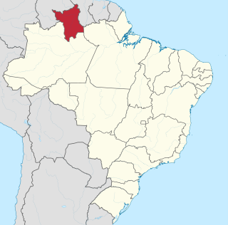
Roraima is one of the 26 states of Brazil. Located in the country's North Region, it is the northernmost and most geographically and logistically isolated state in Brazil. It is bordered by the state of Pará to the southeast, Amazonas to the south and west, Venezuela to the north and northwest, and Guyana to the east.

A tepui, or tepuy, is a table-top mountain or mesa found in South America, especially in Venezuela and western Guyana. The word tepui means "house of the gods" in the native tongue of the Pemon, the indigenous people who inhabit the Gran Sabana.

Mount Roraima is the highest of the Pacaraima chain of tepuis or plateaux in South America. It is located at the junction of Brazil, Guyana and Venezuela. A characteristic large flat-topped mountain surrounded by cliffs 400–1,000 m (1,300–3,300 ft) high. The highest point of Mount Roraima is located on the southern edge of the cliff at an altitude of 2,810 m (9,220 ft) in Venezuela, and another protrusion at an altitude of 2,772 m (9,094 ft) at the junction of the three countries in the north of the plateau is the highest point in Guyana. The name Mount Roraima came from the native Pemon people. Roroi in the Pemon language means "blue-green", and ma means "great".

The Hoover Wilderness is a wilderness area in the Inyo and Humboldt-Toiyabe National Forests. It lies to the east of the crest of the central Sierra Nevada in California, to the north and east of Yosemite National Park - a long strip stretching nearly to Sonora Pass on the north and Tioga Pass on the south.

Cuyuni-Mazaruni is a region of Guyana. Its capital is Bartica, with villages including Issano, Kartabo, Kamarang, and Imbaimadai.

The Mazaruni River is a tributary of the Essequibo River in northern Guyana. Its source is in the remote western forests of the Pakaraima Mountains and its confluence with the Cuyuni River is near Bartica. As it descends from the Guiana Highlands the river runs south-east, past Issano, then northward to Bartica. The river is a source of alluvial gold.
The Pacaraima or Pakaraima Mountains are a mountain range primarily in southwestern Guyana, and into northern Brazil and eastern Venezuela.

The Wapishana or Wapichan are an indigenous group found in the Roraima area of northern Brazil and southern Guyana.

The Ireng River forms part of Guyana's western border with Brazil. It flows through the valleys of the Pakaraima Mountains for most of its length. It is the only major river in Guyana which flows from North to South, up to its confluence into the Takutu River. It is one of the northernmost tributaries of the Amazon river system.
Arakaka is a community in the Barima-Waini region of Guyana, standing on the Barima River and 12 miles southerly of Port Kaituma, at an altitude of 63 metres (209 feet).
The Orinduik Falls lie on the Ireng River, a highland river that thunders over steps and terraces of red jasper on the border of Guyana and Brazil before merging with the Takutu River and into Brazil to join the Amazon River.

The Guayana Region is an administrative region of eastern Venezuela.
Amaila Falls is located on the Kuribrong River, a tributary of the Potaro River in west central Guyana.
The Kurupung River is a tributary of the middle Mazaruni River in Guyana.
The Merume River is a river of Guyana, a tributary of the Kamarang River.

Mount Roraima National Park is a national park in the state of Roraima, northern Brazil.

The Guianan savanna (NT0707) is an ecoregion in the south of Venezuela, Guyana and Suriname and the north of Brazil. It is in the Amazon biome. The savanna covers an area of rolling upland plains on the Guiana Shield between the Amazon and Orinoco basins. It includes forested areas, but these are shrinking steadily due to the effect of frequent fires, either accidental or deliberate. The ecoregion includes the Gran Sabana region of Venezuela.

The Guianan moist forests (NT0125) is an ecoregion in the east of Venezuela, north of Brazil and the Guyanas. It is in the Amazon biome. The climate is hot and humid, with two rainy seasons each year. As of 1996 the tropical rainforest habitat was relatively intact, although there were mounting threats from illegal logging and gold mining.
References
- ↑ "Significant gold deposits in Roraima Basin - study". Stabroek News. 2009-03-22. Retrieved 2021-01-18.
- ↑ Contributions from the United States National Herbarium. U.S. Government Printing Office. 2004. pp. 35–36.