
The St. Marys River, sometimes written St. Mary's River, drains Lake Superior, starting at the end of Whitefish Bay and flowing 74.5 miles (119.9 km) southeast into Lake Huron, with a fall of 23 feet (7.0 m). For its entire length it is an international border, separating Michigan in the United States from Ontario, Canada.

Sipaliwini is the largest district of Suriname, located in the south. Sipaliwini is the only district that does not have a regional capital, as it is directly administered by the national government in Paramaribo.
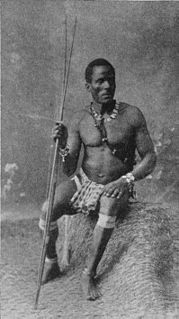
The Saramaka, Saamaka or Saramacca are one of six Maroon peoples in the Republic of Suriname and one of the Maroon peoples in French Guiana. In 2007, the Saramaka won a ruling by the Inter-American Court for Human Rights supporting their land rights in Suriname for lands they have historically occupied, over national government claims. It was a landmark decision for indigenous peoples in the world. They have received compensation for damages and control this fund for their own development goals.

Moengo is a town in Suriname, located in the Marowijne district, between Paramaribo and the border town Albina on the Cottica River. Moengo is also a resort (municipality) in the district of Marowijne. Moengo was the capital of Marowijne District between 1932 and 1945. The current capital is Albina.
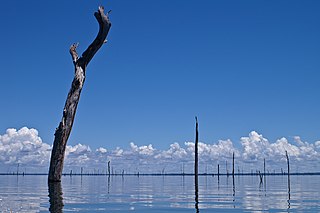
The Brokopondo Reservoir, officially named Professor Doctor Ingenieur W. J. van Blommestein Meer, and also called the Brokopondostuwmeer, is a large reservoir in Suriname. It is named after the Surakarta-born Dutch hydrological engineer Willem Johan van Blommestein. With a surface area of approximately 1,560 km2 (600 sq mi), depending on the current water level, it is one of the largest reservoirs in the world, covering nearly one percent of the country.

Benzdorp is a village in the Sipaliwini District of Suriname. It is named after the English consul and bullion dealer H.J.W. Benz.
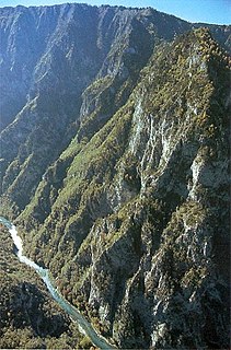
The Tara River Canyon In the Montenegrin Latinized version: Kanjon Tare; pronounced [kǎɲɔːn târɛː]), also known as the Tara River Gorge, is the largest and deepest canyon in Europe, which is for the most part located in Montenegro, and to a smaller extent in Bosnia and Herzegovina. The most attractive part of the canyon are the high rocks of the mountain range of Ljubišnja, which are located in the UNESCO World Heritage Site of Durmitor National Park.
Gran Rio is a river of Suriname. The Gran Rio confluences with the Pikin Rio to form Suriname River. The river runs from the northern hills of the Eilerts de Haan Mountains. It has a stony bottom, forms many tiny islands and has many rapids. At Awarradam, there are many rapids and waterfalls. The river was first explored in 1908 by Eilerts de Haan to find the source of the Suriname River.
The Surinamese Interior War was a civil war waged in the Sipaliwini District of Suriname between 1986 and 1992. It was fought by the Tucayana Amazonas led by Thomas Sabajo and the Jungle Commando led by Ronnie Brunswijk, whose members originated from the Maroon ethnic group, against the National Army led by then-army chief and de facto head of state Dési Bouterse.

Patamacca is a resort in Suriname, located in the Marowijne District. Its population at the 2012 census was 427. Patamacca is a tribal area inhabited by Maroons

Poeketi or Puketi is a Ndyuka village in Suriname. It lies in Sipaliwini District. On May 15, 2010, a plane crashed near Poeketi.
Paloemeu or Palumeu is an Amerindian village in the interior of Suriname, situated at the site where the Paloemeu River joins the Tapanahoni River. Most inhabitants of the village are native Tiriyó Amerindians. The remainder belongs to the Wayana, and Aparai tribes. The Bosatlas in 1968 identified the village as Pepejoe which was incorrect according to the New West Indian Guide.
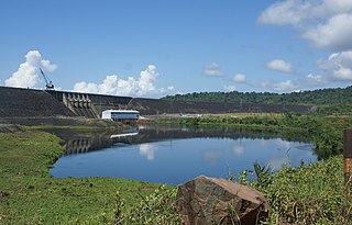
The Afobaka Dam is an embankment dam with a main gravity dam section on the Suriname River near Afobaka in Brokopondo District of Suriname. The primary purpose of the dam is to generate hydroelectric power and it supports a 180 MW power station. In 1958, Suriname Aluminum Company LLC (Suralco), a subsidiary of Alcoa, gained an agreement with the Suriname government to build the dam to power an aluminium smelter. Construction began in 1961 and it was completed in 1964. About 75% of power generated is used for processing aluminum, the rest is used in Paramaribo downstream. The power station was operational in 1965 but the very large reservoir, Brokopondo Reservoir, was not completely filled until 1971. Greenhouse gases emitted from the reservoir resulted in poor water quality for decades. Highly acidic water also damaged the power station's turbines.
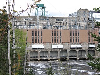
The Rapide-Blanc generating station is a hydroelectric facility, comprising a reservoir, a dam and a hydroelectric plant. It is located on the Saint-Maurice River about sixty kilometres (37 mi) north of the city of La Tuque, in Quebec, in Canada. Built between 1930 and 1934 by the Shawinigan Water & Power Company (SWPC), it is the third hydroelectric facility on this river. The plant has been operated by Hydro-Québec since it was acquired from the SWPC in 1963, as part of the nationalisation of electric power companies in Quebec. The plant has a rated power of 204 megawatts (274,000 hp).

Diitabiki is a Ndyuka village in the Sipaliwini District of Suriname. Diitabiki is the residence of the gaanman of the Ndyuka people, since 1950, and the location of the oracle.
The Gran Olo hydroelectric power plant is a mini hydro power plant under construction on the Tapanahony River in Suriname with a projected capacity of 300 kilowatts (400 hp), although initially only one turbine with a capacity of 150 kilowatts (200 hp) will be operated. The power plant will initially provide electricity to the villages of Puketi and Futupasi, but in the future extension of the grid to villages in the region is foreseen.
The Puketi hydroelectric power plant was a micro hydropower plant constructed near the village of Puketi in Suriname, with a capacity of 50 kW (67 hp). The plant provided electricity between 1981 and 1987 before it went into disrepair. According to hydrologist Rudi van Els, the plant could be rehabilitated, but efforts are now focussed on the construction of the Gran Olo hydroelectric power plant nearby.

The Sjønstå River is a river in the municipality of Fauske in Nordland county, Norway. The river is located in the valley between the town of Fauske and the village of Sulitjelma.

Lensidede or Lessé Dédé, is a Surinamese village on an island in the Lawa River, near the Lensidede rapids after which the village was named. In the village live Wayana people.
Ovia Olo, also Ovillanhollo, is a village of Ndyuka Maroons in the Patamacca resort of the Marowijne District of Suriname.
