Corneliskondre is a village in Suriname, located in the Boven Coppename resort of Sipaliwini District. It has a population of 70 as of 2020, and is inhabited by indigenous people of the Kalina tribe.

Brokopondo is the capital town of the Brokopondo District, Suriname. It is located on the west shore of the Suriname river, just north of the Afobaka dam, 105 kilometers south-east of Suriname capital city of Paramaribo. Brokopondo can be reached via the Afobakaweg from Paranam to Afobaka.
Kwamalasamutu, also Kwamalasamoetoe, is a Tiriyó Amerindian village in the Sipaliwini District of Suriname, and home to the granman of the northern Trios. Kwamalasamutu is the biggest village of the Tiriyó tribe.
Lebidoti is a village in Suriname with a population of about 1,000 and two nearby villages of Bakoe and Pitean. The people are of Maroon descent, specifically the Aukan tribe, and moved to this specific location when the building of the Afobaka dam created the Brokopondo Reservoir.

Kajana is a village in Sipaliwini District, Suriname. It lies on the Gaan-lio, which together with the Pikin Lio forms the Suriname River. The population call themselves Kadosi-nengre after Cardoso who was the owner of the plantation they ran away from. The village is home to Maroons of the Saramaka tribe.

Apoera, also Apura, is a town in western Suriname. The village has a population of 777 people as of 2020. It is the final destination of the Southern East-West Link. 24 kilometres (15 mi) north-west on the other side of the Courantyne River lies the Guyanese village of Orealla. The village is home to the Lokono tribe, but has been westernized. Due to the influx of people of Guyana, the languages used are English, and Sranan Tongo. Dutch is rarely spoken and the native language has all but disappeared. According to the oral tradition, Apoera was founded around 1920 by the Gordon family.

Aurora is a town in the Sipaliwini District of Suriname on the Upper Suriname River. Aurora is a tribal village, and has a twin village called Nieuw Aurora which was built as an extension. The village is home to Maroons of the Saramaka tribe.
Witagron is a Kwinti village in Suriname on the Coppename River at the crossing of the Southern East-West Link from Paramaribo to Apoera in West-Suriname.

Pokigron is a town in Suriname located on the Upper Suriname River near the Brokopondo Reservoir. It is located in the Boven Suriname municipality (resort) in the Sipaliwini District. It has a population of approximately 400 people in 2018. Pokigron is located at the end of a paved road via Brownsweg to the Afobakaweg. Pokigron is often referred to as Atjoni which is the nearby quay, and literally the end of the road. Villages to the South of Pokigron have to be accessed by boat. The village is home to Maroons of the Saramaka tribe.

Pelelu Tepu is an Amerindian village in the hinterland of Suriname. Also known as "Pe'reru Tepu", the village is typically referred to simply as "Tepu," which mean "high" in the Indian Tiriyó language. The village is located on Tepu hill, on the Tapanahoni River. Though inhabited by Amerindian tribes indigenous to the area, the village was founded by Christian missionaries and (primarily) Tiriyó Indians, although it now also includes small numbers of Wayana and Akuriyo Indians. The village has a tribal organization, led by a Trio Captain.

Klaaskreek is a resort in Suriname, located in the Brokopondo District. Its population at the 2012 census was 2,124. Located northeast of Brokopondo, the main town is Reinsdorp. In 2007, a technical training centre in biological agriculture was established at Klaaskreek to teach locals about enhancing agriculture in the area.

Marshallkreek is a resort in Suriname, located in the Brokopondo District. Its population at the 2012 census was 1,171. The resort and town are named after Captain Marshall who first settled Suriname in 1630.
Paloemeu or Palumeu is an Amerindian village in the interior of Suriname, situated at the site where the Paloemeu River joins the Tapanahoni River. Most inhabitants of the village are native Tiriyó Amerindians. The remainder belongs to the Wayana, and Aparai tribes. The Bosatlas in 1968 identified the village as Pepejoe which was incorrect according to the New West Indian Guide.

Afobaka is a village in the Brokopondo District of Suriname. Between 1960 and 1964, the 1913 meter-long Afobaka Dam was built on the Suriname River, creating the Brokopondo Reservoir. The Afobaka Airstrip is nearby.

Diitabiki is a Ndyuka village in the Sipaliwini District of Suriname. Diitabiki is the residence of the gaanman of the Ndyuka people, since 1950, and the location of the oracle.

Langatabiki is a Paramacca village in the Sipaliwini District of Suriname. Langatabiki is the residence of the granman of the Paramaccan people. Langatabiki is located in the Pamacca resort which was created on 11 September 2019 out of Tapanahony.
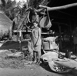
Medische Zending Primary Health Care Suriname, commonly known as Medische Zending or MZ is a Surinamese charitable organization offering primary healthcare to remote villages in the interior of Suriname.

Paramacca is a resort in Suriname, located in the Sipaliwini District. The population is estimated between 1,500 and 2,000 people. In 1983, the Sipaliwini District was created, and the eastern part became the resort of Tapanahony. The Paramacca resort is the northern part of Tapanahony, and mainly inhabited by the Paramaccan people, the border of the resorts is the island of Bofoo Tabiki in the Marowijne River.
Nason is a village of Paramacca Maroons in the Sipaliwini District of Suriname. The village is located on an island in the Marowijne River.

The Upper Suriname River is the upper reach of the Suriname River. Shortly before the transition to the Lower Suriname River, there is the Brokopondo Reservoir. From there, the access by road ends at the jetty of Atjoni, near Pokigron. The Suriname River begins at the confluence of the Gran Rio and Pikin Rio near the village of Goddo with the Tapawatrasula rapids.

