
Brokopondo is a district of Suriname. Its capital city is Brokopondo; other towns include Brownsweg and Kwakoegron.

Sipaliwini is the largest district of Suriname, located in the south. Sipaliwini is the only district that does not have a regional capital, as it is directly administered by the national government in Paramaribo. Sipaliwini District includes disputed areas, with the southwestern region controlled and administered by Guyana, whereas the southeastern region is controlled by French Guiana.

Wanica is a district of Suriname located in the north of the country. Wanica's capital city is Lelydorp, the second-largest city in Suriname. Wanica has a population of 118,222 and an area of 443 km2. Following neighboring Paramaribo, Wanica is the second most populated and urbanized district of Suriname. Two-thirds of the country's population live in these two districts.

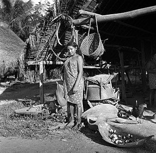
The Paramaccan or Paramaka are a Maroon tribe living in the forested interior of Suriname, mainly in the Paramacca resort, and the western border area of French Guiana. The Paramaccan signed a peace treaty in 1872 granting the tribe autonomy.
Corneliskondre is a village in Suriname, located in the Boven Coppename resort of Sipaliwini District. It has a population of 70 as of 2020, and is inhabited by indigenous people of the Kalina tribe.

Tapanahoni is a resort in Suriname, located in the Sipaliwini District. Its population at the 2012 census was 13,808. Tapanahoni is a part of Sipaliwini which has no capital, but is directly governed from Paramaribo. Tapanahony is an enormous resort which encompasses a quarter of the country of Suriname. The most important town is Diitabiki which is the residence of the granman of the Ndyuka people since 1950, and the location of the oracle.

Kajana is a village in Sipaliwini District, Suriname. It lies on the Gaan-lio, which together with the Pikin Rio forms the Suriname River. The population call themselves Kadosi-nengre after Cardoso who was the owner of the plantation they ran away from. The village is home to Maroons of the Saramaka tribe.

Apoera, also Apura, is a town in western Suriname. The village has a population of 777 people as of 2020. It is the final destination of the Southern East-West Link. 24 kilometres (15 mi) north-west on the other side of the Courantyne River lies the Guyanese village of Orealla. The village is home to the Lokono tribe, but has been westernized. Due to the influx of people of Guyana, the languages used are English, and Sranan Tongo. Dutch is rarely spoken and the native language has all but disappeared. According to the oral tradition, Apoera was founded around 1920 by the Gordon family.

Botopasi, also spelled Boto-Pasi, is a Saamaka village in Suriname. The village had a population of about 740 people in 2001.

Pokigron is a town in Suriname located on the Upper Suriname River near the Brokopondo Reservoir. It is located in the Boven Suriname municipality (resort) in the Sipaliwini District. It has a population of approximately 400 people in 2018. Pokigron is located at the end of a paved road via Brownsweg to the Avobakaweg. Pokigron is often referred to as Atjoni which is the nearby quay, and literally the end of the road. Villages to the South of Pokigron have to be accessed by boat. The village is home to Maroons of the Saramaka tribe.
Nieuw Jacobkondre is a town in the Sipaliwini District of Suriname. It is situated on the Saramacca River. The village is inhabited by Matawai people.

Boven Suriname is a resort in Suriname, located in the Sipaliwini District. Its population at the 2012 census was 17,954. Almost its entire population consists of Maroons
Boven Saramacca is a resort in Suriname, located in the Sipaliwini District. Its population at the 2012 census was 1,427. The dominant geographical feature of this resort is the Saramacca River. The resort is mainly inhabited by Maroons of the Matawai tribe.
Bakhuys is a village in the Kabalebo resort of the Sipaliwini District in Suriname. The village is located near the Bakhuis Mountains. Bakhuis is mainly known for its large bauxite mine which is exploited by Suralco. In 1995, the refinery had received a $120 million upgrade and extension. The village and mountain range have been named after Louis August Bakhuis who led a 1901 expedition into the area.

Paramacca is a resort in Suriname, located in the Sipaliwini District. The population is estimated between 1,500 and 2,000 people. In 1983, the Sipaliwini District was created, and the eastern part became the resort of Tapanahony. The Paramacca resort is the northern part of Tapanahony, and mainly inhabited by the Paramaccan people, the border of the resorts is the island of Bofoo Tabiki in the Marowijne River.
Pikin Slee is a village on the Upper Suriname River in the resort Boven Suriname of the Sipaliwini District. It is home to about 3,000 people, and the second largest village of the Saramaka Maroons, after Aurora.

Godo Holo is a group of villages in the Tapanahony resort of the Sipaliwini District of Suriname. The villages are inhabited by Maroons of the Ndyuka people.

Donderskamp is an indigenous village of Kalina Amerindians in the resort of Boven Coppename in the Sipaliwini District in Suriname. The village is located on the Wayambo River.

Manlobi is a village of Ndyuka Maroons in the Sipaliwini District of Suriname. The village is located on an island in the Tapanahony River.
Snesiekondre is a village of Paramacca Maroons in the Sipaliwini District of Suriname. The village is located at the end of the road connecting Langatabiki to Patamacca and the rest of Suriname.

