Abenaston is a village on the Upper Suriname River in Suriname with a population of about 700 people in 2005. The population consists of Saramaka Maroons.
Kawemhakan, formerly also known as Anapaikë, is a Wayana village in the Sipaliwini District of Suriname. The village lies on the banks of the Lawa River, which forms the border with French Guiana.

Aurora is a town in the Sipaliwini District of Suriname on the Upper Suriname River. Aurora is a tribal village, and has a twin village called Nieuw Aurora which was built as an extension. The village is home to Maroons of the Saramaka tribe.

Botopasi, also spelled Boto-Pasi, is a Saamaka village in Suriname. The village had a population of about 740 people in 2001.
Goddo is a small village in Suriname. The village sits on the Upper Suriname River, 1.81 kilometres north of the Pikin River. Goddo can be reached via the Djumu Airstrip, or by boat from Pokigron. The village is home to Maroons of the Saramaka tribe.

Pokigron is a town in Suriname located on the Upper Suriname River near the Brokopondo Reservoir. It is located in the Boven Suriname municipality (resort) in the Sipaliwini District. It has a population of approximately 400 people in 2018. Pokigron is located at the end of a paved road via Brownsweg to the Afobakaweg. Pokigron is often referred to as Atjoni which is the nearby quay, and literally the end of the road. Villages to the South of Pokigron have to be accessed by boat. The village is home to Maroons of the Saramaka tribe.
Zoewatta is a village in the Boven Suriname municipality (resort) in Sipaliwini District in Suriname. It is located on Brokopondo Reservoir.
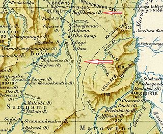
Warnakomoponafaja is a village in Boven Saramacca municipality (resort) in Sipaliwini District in Suriname.
Moetoetoetabriki is a village in Boven Saramacca resort in Sipaliwini District in Suriname. The village is inhabited by Matawai people.
Kwattahede is a village in Boven Saramacca resort in Sipaliwini District in Suriname. The village is inhabited by Matawai people.
Makajapingo is a village in Boven Saramacca (resort) in Sipaliwini District in Suriname. The village is inhabited by Matawai people.
Pakka-Pakka or Pakkapakka, also Pakkapakka 1 and Pakkapakka 2, is a Maroon village in the rainforest of Boven Saramacca resort in Sipaliwini District in Suriname. The village is inhabited by Matawai people. The village was founded in the 1860s and was originally home to both Matawai and Kwinti people.

The Surinamese Interior War was a civil war waged in the Sipaliwini District of Suriname between 1986 and 1992. It was fought by the Tucayana Amazonas led by Thomas Sabajo and the Jungle Commando led by Ronnie Brunswijk, whose members originated from the Maroon ethnic group, against the National Army led by then-army chief and de facto head of state Dési Bouterse.

Boven Suriname is a resort in Suriname, located in the Sipaliwini District. Its population at the 2012 census was 17,954. Almost its entire population consists of Maroons
Boven Saramacca is a resort in Suriname, located in the Sipaliwini District. Its population at the 2012 census was 1,427. The dominant geographical feature of this resort is the Saramacca River. The resort is mainly inhabited by Maroons of the Matawai tribe.
Poesoegroenoe or Pusugrunu or Psugrunu is a Matawai village in Boven Saramacca, Sipaliwini District, central Suriname. The village lies along the Saramacca River and is the residence of the gaanman of the Matawai maroons.
Hugo Jabini is a Saramaka Maroon politician and environmental leader from Suriname. In 1998 he became the spokesman of the Association of Saamaka Authorities. In 2007 he and Wanze Eduards were part of the VSG team that won an landrights lawsuit against the Surinamese government in international court. For their work in the landrights struggle they shared the Goldman Environmental Prize in 2009. From 2010 to 2015 Jabini was a member of the Surinamese National Assembly, as part of the National Democratic Party (NDP).
Pikin Slee is a village on the Upper Suriname River in the resort Boven Suriname of the Sipaliwini District. It is home to about 3,000 people, and the second largest village of the Saramaka Maroons, after Aurora.

The 2022 Suriname floods beginning in March have affected Indigenous and Maroon settlement areas in the eastern part of Suriname. The floods were caused by the La Niña weather phenomenon, which replaced the short dry season in 2022.

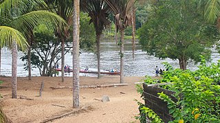
The Upper Suriname River is the upper reach of the Suriname River. Shortly before the transition to the Lower Suriname River, there is the Brokopondo Reservoir. From there, the access by road ends at the jetty of Atjoni, near Pokigron. The Suriname River begins at the confluence of the Gran Rio and Pikin Rio near the village of Goddo with the Tapawatrasula rapids.
