Marowijne is a district of Suriname, located on the north-east coast. Marowijne's capital city is Albina, with other towns including Moengo and Wanhatti. The district borders the Atlantic Ocean to the north, French Guiana to the east, the Surinamese district of Sipaliwini to the south, and the Surinamese districts of Commewijne and Para to the west.

Sipaliwini is the largest district of Suriname, located in the south. Sipaliwini is the only district that does not have a regional capital, as it is directly administered by the national government in Paramaribo. Sipaliwini District includes disputed areas, with the southwestern region controlled and administered by Guyana, whereas the southeastern region is controlled by French Guiana.

The Paramaccan or Paramaka are a Maroon tribe living in the forested interior of Suriname, mainly in the Paramacca resort, and the western border area of French Guiana. The Paramaccan signed a peace treaty in 1872 granting the tribe autonomy.

Cottica Lawa, often shortened to Cottica and also called Cotticadorp is a village in the district of Sipaliwini, Suriname. It is located in the east, along the Marowijne River and the border with French Guiana. The village has a school, and a clinic.

Tapanahoni is a resort in Suriname, located in the Sipaliwini District. Its population at the 2012 census was 13,808. Tapanahoni is a part of Sipaliwini which has no capital, but is directly governed from Paramaribo. Tapanahony is an enormous resort which encompasses a quarter of the country of Suriname. The most important town is Diitabiki which is the residence of the granman of the Ndyuka people since 1950, and the location of the oracle.
Kwamalasamutu, also Kwamalasamoetoe, is a Tiriyó Amerindian village in the Sipaliwini District of Suriname, and home to the granman of the northern Trios. Kwamalasamutu is the biggest village of the Tiriyó tribe and is located near the disputed border with Guyana.
Witagron is a Kwinti village in Suriname on the Coppename River at the crossing of the Southern East-West Link from Paramaribo to Apoera in West-Suriname.

Djumu, also spelled Djoemoe, is a village in Suriname. It is located at the confluence of the Gran Rio and the Pikin Rio which continue as the Upper Suriname River. The village is home to Maroons of the Saramaka tribe.

Pokigron is a town in Suriname located on the Upper Suriname River near the Brokopondo Reservoir. It is located in the Boven Suriname municipality (resort) in the Sipaliwini District. It has a population of approximately 400 people in 2018. Pokigron is located at the end of a paved road via Brownsweg to the Avobakaweg. Pokigron is often referred to as Atjoni which is the nearby quay, and literally the end of the road. Villages to the South of Pokigron have to be accessed by boat. The village is home to Maroons of the Saramaka tribe.

The ten districts of Suriname are divided into 63 resorts. Within the capital city of Paramaribo, a resort entails a neighbourhood; in other cases it is more akin to a municipality, consisting of a central place with a few settlements around it. The resorts in the Sipaliwini District are especially large, since the interior of Suriname is sparsely inhabited.
Poesoegroenoe or Pusugrunu or Psugrunu is a Matawai village in Boven Saramacca, Sipaliwini District, central Suriname. The village lies along the Saramacca River and is the residence of the gaanman of the Matawai maroons.
Paloemeu or Palumeu is an Amerindian village in the interior of Suriname, situated at the site where the Paloemeu River joins the Tapanahoni River. Most inhabitants of the village are native Tiriyó Amerindians. The remainder belongs to the Wayana, and Aparai tribes. The Bosatlas in 1968 identified the village as Pepejoe which was incorrect according to the New West Indian Guide.

The Ndyuka people or Aukan people (Okanisi), are one of six Maroon peoples in the Republic of Suriname and one of the Maroon peoples in French Guiana. The Aukan or Ndyuka speak the Ndyuka language. They are subdivided into the Opu, who live upstream of the Tapanahony River in the Tapanahony resort of southeastern Suriname, and the Bilo, who live downstream of that river in Marowijne District.

Diitabiki is a Ndyuka village in the Sipaliwini District of Suriname. Diitabiki is the residence of the gaanman of the Ndyuka people, since 1950, and the location of the oracle.

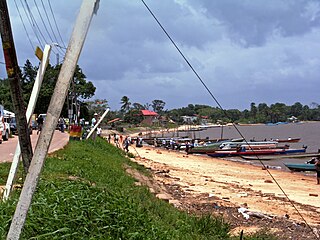
Stoelmanseiland is an island, and a village in the Paramacca resort of the Sipaliwini District in Suriname. It is located at the confluence of the Tapanahony River with the Lawa River which forms the Marowijne River, and is also the border with French Guiana.

Paramacca is a resort in Suriname, located in the Sipaliwini District. The population is estimated between 1,500 and 2,000 people. In 1983, the Sipaliwini District was created, and the eastern part became the resort of Tapanahony. The Paramacca resort is the northern part of Tapanahony, and mainly inhabited by the Paramaccan people, the border of the resorts is the island of Bofoo Tabiki in the Marowijne River.

Godo Holo is a group of villages in the Tapanahony resort of the Sipaliwini District of Suriname. The villages are inhabited by Maroons of the Ndyuka people.

Antonio do Brinco, also Albina 2, is a garimpeiros village in the Tapanahony resort of the Sipaliwini District of Suriname. The village is located on the Lawa River, and is next to Peruano, and opposite Maripasoula in French Guiana. The village is named after Antonio with the earring who constructed the first commercial building.
Nason is a village of Paramacca Maroons in the Sipaliwini District of Suriname. The village is located on an island in the Marowijne River.
Lokaloka is a village of Paramacca maroons in the Sipaliwini District of Suriname. The village is located on an island in the Marowijne River. Lokaloka is the last village of the Paramacca people.

