
Sipaliwini is the largest district of Suriname, located in the south. Sipaliwini is the only district that does not have a regional capital, as it is directly administered by the national government in Paramaribo.

Nieuw Nickerie is the third largest city in Suriname with a population estimated at 12,818. It is the capital city of the Nickerie district, and the terminus of the East-West Link.
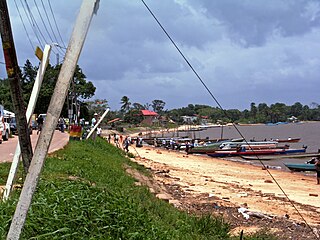
Albina is a town in eastern Suriname, and is capital of the Marowijne District. The town lies on the west bank of the Marowijne river, which forms the border with French Guiana, directly opposite the French Guianan town of Saint-Laurent-du-Maroni, to which it is connected by a frequent ferry service. Albina can be reached by bus via the East-West Link. The distance between Paramaribo and Albina is about 150 kilometres (95 mi).

Wageningen is a community resort and an agricultural place in the Republic of Suriname and located in the coastal area of West Suriname in the Nickerie District, at the harbour of the Nickerie River across the right estuary of the Maratakka River. The town was known as the rice centre of Suriname, Wageningen has been founded in 1949 and named after the Dutch city of Wageningen.
Corneliskondre is a village in Suriname, located in the Boven Coppename resort of Sipaliwini District. It has a population of 70 as of 2020, and is inhabited by indigenous people of the Kalina tribe.
Kwamalasamutu, also Kwamalasamoetoe, is a Tiriyó Amerindian village in the Sipaliwini District of Suriname, and home to the granman of the northern Trios. Kwamalasamutu is the biggest village of the Tiriyó tribe.

Apoera, also Apura, is a town in western Suriname. The village has a population of 777 people as of 2020. It is the final destination of the Southern East-West Link. 24 kilometres (15 mi) north-west on the other side of the Courantyne River lies the Guyanese village of Orealla. The village is home to the Lokono tribe, but has been westernized. Due to the influx of people of Guyana, the languages used are English, and Sranan Tongo. Dutch is rarely spoken and the native language has all but disappeared. According to the oral tradition, Apoera was founded around 1920 by the Gordon family.

Kabalebo River is a river in Suriname. It joins with the Courantyne River near Apoera. A plan for a dam in the river serving a hydroelectric power plant is part of the West Suriname Plan of the 1960s. As of 2020, no construction has taken place. Petrogylphs had been discovered on a rock by Ten Kate in 1886.

Noord is a resort in Suriname, located in the Para District. Its population at the 2012 census was 9,703. Noord is mainly an agricultural area, and has a school.

Kabalebo is a resort in Suriname, located in the Sipaliwini District. Its population at the 2012 census was 2,291.
Galibi is a resort in Suriname, located in the Marowijne District. Its population at the 2012 census was 741. Galibi is a tribal area inhabited by an indigenous population of Kalina Amerindians.
Paloemeu or Palumeu is an Amerindian village in the interior of Suriname, situated at the site where the Paloemeu River joins the Tapanahoni River. Most inhabitants of the village are native Tiriyó Amerindians. The remainder belongs to the Wayana, and Aparai tribes. The Bosatlas in 1968 identified the village as Pepejoe which was incorrect according to the New West Indian Guide.
Bakhuys is a village in the Kabalebo resort of the Sipaliwini District in Suriname. The village is located near the Bakhuis Mountains. Bakhuis is mainly known for its large bauxite mine which is exploited by Suralco. In 1995, the refinery had received a $120 million upgrade and extension. The village and mountain range have been named after Louis August Bakhuis who lead an 1901 expedition into the area.
Amatopo or Amotopo is a Tiriyó village on the Courentyne River in the Sipaliwini District of Suriname. The village lies next to the Amatopo Airstrip and about 7 kilometres (4.3 mi) upstream from the village of Lucie. The Frederik Willem IV Falls and Arapahu Island are located near the village.
Sandlanding is a Tiriyó village in the Sipaliwini District of Suriname. The village lies just south of Apoera, which is mainly inhabited by Arowaks.
Wanapan or Arapahtë pata is a Tiriyó village in the Sipaliwini District of Suriname. It was established at the bottom of the Wonotobo Falls in 1998 by captain Arapahtë.
The Tucayana Amazonas was an Amerindian guerrilla commando group in Suriname.

Donderskamp is an indigenous village of Kalina Amerindians in the resort of Boven Coppename in the Sipaliwini District in Suriname. The village is located on the Wayambo River.
Pikin Saron is an indigenous village of Kalina Amerindians in the resort of Zuid in the Para District in Suriname. The village can be accessed from the Southern East-West Link, and is located on the Saramacca River.
Hollandse Kamp is an indigenous village of Lokono Amerindians in the resort of Zuid in the Para District in Suriname. The village is located south of the Johan Adolf Pengel International Airport.
