
Brokopondo is a district of Suriname. Its capital city is Brokopondo; other towns include Brownsweg and Kwakoegron.

Tapanahoni is a resort in Suriname, located in the Sipaliwini District. Its population at the 2012 census was 13,808. Tapanahoni is a part of Sipaliwini which has no capital, but is directly governed from Paramaribo. Tapanahony is an enormous resort which encompasses a quarter of the country of Suriname. The most important town is Diitabiki which is the residence of the granman of the Ndyuka people since 1950, and the location of the oracle.

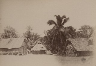
Kajana is a village in Sipaliwini District, Suriname. It lies on the Gaan-lio, which together with the Pikin Rio forms the Suriname River. The population call themselves Kadosi-nengre after Cardoso who was the owner of the plantation they ran away from. The village is home to Maroons of the Saramaka tribe.
Abenaston is a village on the Upper Suriname River in Suriname with a population of about 700 people in 2005. The population consists of Saramaka Maroons.

Aurora is a town in the Sipaliwini District of Suriname on the Upper Suriname River. Aurora is a tribal village, and has a twin village called Nieuw Aurora which was built as an extension. The village is home to Maroons of the Saramaka tribe.

Botopasi, also spelled Boto-Pasi, is a Saamaka village in Suriname. The village had a population of about 740 people in 2001.

Djumu, also spelled Djoemoe, is a village in Suriname. It is located at the confluence of the Gran Rio and the Pikin Rio which continue as the Upper Suriname River. The village is home to Maroons of the Saramaka tribe.

Pelelu Tepu is an Amerindian village in the hinterland of Suriname. Also known as "Pe'reru Tepu", the village is typically referred to simply as "Tepu," which means "high" in the Indian Tiriyó language. The village is located on Tepu hill, on the Tapanahoni River. Though inhabited by Amerindian tribes indigenous to the area, the village was founded by Christian missionaries and (primarily) Tiriyó Indians, although it now also includes small numbers of Wayana and Akuriyo Indians. The village has a tribal organization, led by a Trio Captain.
Nieuw Jacobkondre is a town in the Sipaliwini District of Suriname. It is situated on the Saramacca River. The village is inhabited by Matawai people.

Johan & Margaretha or sometimes just Margaretha is a resort in Suriname, located in the Commewijne District. Its population at the 2012 census was 756. It is located along a peninsula northeast of Paramaribo. It is named after the coffee plantation Johan & Margaretha which was founded in 1745 by Johan Knöffel. It is safe to assume that his wife was called Margaretha.

Noord is a resort in Suriname, located in the Para District. Its population at the 2012 census was 9,703. Noord is mainly an agricultural area, and has a school.
Oost is a resort in Suriname, located in the Para District. Its population at the 2012 census was 8,016. The main town in the resort is Paranam. Oost is also home to the former leper colony Bethesda. The Paranam alumina refinery is located near the town of Paranam. The Accaribo area is becoming tourist spot with the main attractions White Beach and Caribo Beach Resort.

Kabalebo is a resort in Suriname, located in the Sipaliwini District. Its population at the 2012 census was 2,291.

Boven Suriname is a resort in Suriname, located in the Sipaliwini District. Its population at the 2012 census was 17,954. Almost its entire population consists of Maroons
Boven Saramacca is a resort in Suriname, located in the Sipaliwini District. Its population at the 2012 census was 1,427. The dominant geographical feature of this resort is the Saramacca River. The resort is mainly inhabited by Maroons of the Matawai tribe.

Boven Coppename is a resort in Suriname, located in the Sipaliwini District. Its population at the 2012 census was 539. The resort is mainly inhabited by indigenous people of the Tiriyó, and Maroons of the Kwinti tribe. The main village is Bitagron. Other villages include Corneliskondre and Donderskamp.

Calcutta is a resort in Suriname, located in the Saramacca District. Its population at the 2012 census was 1,647, and is mainly inhabited by East Indians. The town is named after Calcutta, India. From 1873 onwards, indentured workers were recruited from India to work the plantations. Most of the workers departed from Calcutta. About one third returned to India, but most decided to stay in Suriname.

Kampong Baroe is a resort in Suriname, located in the Saramacca District. Its population at the 2012 census was 2,248, the majority being Javanese, and East Indian. The main agricultural crop is peanuts. Kampong Baroe also contains cattle, pig, and chicken farms. "Kampong Baroe" in Malay language literally means "New Village".
Tijgerkreek is a resort in Suriname, located in the Saramacca District. Its population at the 2012 census was 3,244, the majority being Javanese, and East Indian. The resort is mainly agricultural. In the 21st century, there has been an emphasis on peanuts. The development of a modern agricultural centre is being planned.
Wayamboweg is a resort in Suriname, located in the Saramacca District. Its population at the 2012 census was 1,560. The largest ethnic group is East Indian. The resort is mainly agricultural. A rice project has started in late 2017.
