
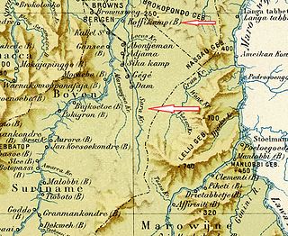
Brokopondo is a district of Suriname. Its capital city is Brokopondo; other towns include Brownsweg and Kwakoegron.

Para is a district of northern Suriname. Para's capital city is Onverwacht, with other towns including Paranam, and Zanderij. Para has a population of 24,700 and an area of 5,393 km2. The district is the mining and forestry centre of Suriname, with many large bauxite mining operations operating. The district is a mixture of forest and savannas.
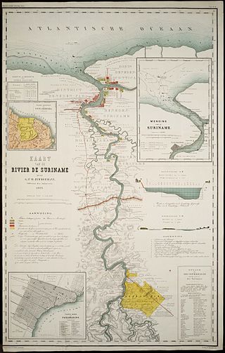
The Suriname River is 480 km long and flows through the country Suriname. Its sources are located in the Guiana Highlands on the border between the Wilhelmina Mountains and the Eilerts de Haan Mountains. The source of the Upper Suriname River is at the confluence of the Gran Rio and Pikin Rio near the village of Goddo. The river continues shortly after the reservoir along Brokopondo as the Lower Suriname River. Than it flows Berg en Dal, the migrant communities Klaaskreek and Nieuw-Lombé, Jodensavanne, Carolina, Ornamibo and Domburg, before reaching the capital Paramaribo on the left bank and Meerzorg on the right bank. At Nieuw-Amsterdam it is joined by the Commewijne and immediately thereafter at the sandspit Braamspunt it flows into the Atlantic Ocean.
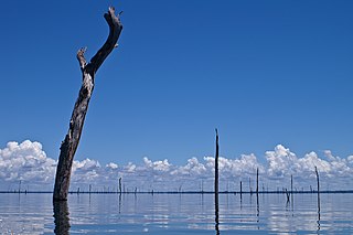
The Brokopondo Reservoir, officially named Professor Doctor Ingenieur W. J. van Blommestein Meer, and also called the Brokopondostuwmeer, is a large reservoir in Suriname. It is named after the Surakarta-born Dutch hydrological engineer Willem Johan van Blommestein. With a surface area of approximately 1,560 km2 (600 sq mi), depending on the current water level, it is one of the largest reservoirs in the world, covering nearly one percent of the country.

Brownsweg is a town and resort in Suriname in the Brokopondo District. Its population at the 2012 census was 4,793.

Pokigron is a town in Suriname located on the Upper Suriname River near the Brokopondo Reservoir. It is located in the Boven Suriname municipality (resort) in the Sipaliwini District. It has a population of approximately 400 people in 2018. Pokigron is located at the end of a paved road via Brownsweg to the Afobakaweg. Pokigron is often referred to as Atjoni which is the nearby quay, and literally the end of the road. Villages to the South of Pokigron have to be accessed by boat. The village is home to Maroons of the Saramaka tribe.
Zoewatta is a village in the Boven Suriname municipality (resort) in Sipaliwini District in Suriname. It is located on Brokopondo Reservoir.
Danta Bai, also called Dan ta bai, is a village on the Upper Suriname River. It is located in municipality (resort) Boven Suriname in Brokopondo District in Suriname.
Warnakomoponafaja is a village in Boven Saramacca municipality (resort) in Sipaliwini District in Suriname.
Kwattahede is a village in Boven Saramacca resort in Sipaliwini District in Suriname. The village is inhabited by Matawai people.
Pakka-Pakka or Pakkapakka, also Pakkapakka 1 and Pakkapakka 2, is a Maroon village in the rainforest of Boven Saramacca resort in Sipaliwini District in Suriname. The village is inhabited by Matawai people. The village was founded in the 1860s and was originally home to both Matawai and Kwinti people.
Afobaka Airstrip is an airstrip near Afobaka, a village in the Brokopondo District of Suriname. The airstrip is primarily used for emergency evacuation and gold shipment. It is 5 kilometres (3.1 mi) from the campsite of the Gross Rosebel gold mine, which has its own airstrip.

Centrum is a resort in Suriname, located in the Brokopondo District. Its population at the 2012 census was 4,482. Centrum can be reached by car via the Afobakaweg from Paranam to Afobaka, or by boat via the Suriname River.

Klaaskreek is a resort in Suriname, located in the Brokopondo District. Its population at the 2012 census was 2,124. Located northeast of Brokopondo, the main town is Reinsdorp. In 2007, a technical training centre in biological agriculture was established at Klaaskreek to teach locals about enhancing agriculture in the area.

Sarakreek is a resort in the gold mining region of Brokopondo District in Suriname. Its population at the 2012 census was 3,076. It is served by the Sarakreek Airstrip. The resort is named after the eponymous creek.

Afobaka is a village in the Brokopondo District of Suriname. Between 1960 and 1964, the 1913 meter-long Afobaka Dam was built on the Suriname River, creating the Brokopondo Reservoir. The Afobaka Airstrip is nearby.
Ganzee is a former village in the Brokopondo District of Suriname. The village was home to Maroons of the Saramaka tribe, and located on the Suriname River. In 1965, the village was flooded after the construction of the Afobaka Dam.
Jaw Jaw, also Yaw Yaw, is a village of Saamaka Maroons in the Boven Suriname resort of the Sipaliwini District of Suriname. The village is located on the Suriname River.
Nieuw-Lombe is a village in the resort of Klaaskreek in the Brokopondo District of Suriname. The village is located on the Suriname River, and is inhabitated by Saramaka maroons. Nieuw-Lombe is a transmigration village built for the inhabitants of Lombé which was flooded by the Brokopondo Reservoir after the construction of the Afobaka Dam.

The Upper Suriname River is the upper reach of the Suriname River. Shortly before the transition to the Lower Suriname River, there is the Brokopondo Reservoir. From there, the access by road ends at the jetty of Atjoni, near Pokigron. The Suriname River begins at the confluence of the Gran Rio and Pikin Rio near the village of Goddo with the Tapawatrasula rapids.
