The first European settlement was established in 1527, at the confluence of the Paraná and Carcarañá rivers, when Sebastian Cabot, on his way to the north, founded a fort named Sancti Spiritus, which was destroyed two years later by the natives.
In 1573 Juan de Garay founded the city of Santa Fe in the surroundings of present town Cayastá, but the city was moved in 1651 and 1660 to its present location.
In 1812 the lawyer and general Manuel Belgrano created and displayed for the first time the Argentine flag on the banks of the Paraná River, at Rosario (by that time a small village), 160km (99mi) south of Santa Fe.
In 1815, while Alvear's central government fell due to Ignacio Álvarez Thomas' rebellion (at that time commander of an army sent to Santa Fe against Artigas), Francisco Candioti, the local militia chief, took over the government peacefully, thus starting the era of Santa Fe as an autonomous province. This period was short lived, since that same year Candioti died and central government reestablished the dependent government. However, in 1816, the caudillosMariano Vera and Estanislao López deposed the governor delegate and proclaimed the sovereignty of the province and its membership into Artigas's Free Peoples League (Liga de Pueblos Libres).
López drew, in 1818, a provincial constitution of a strongly conservative flavour, after rejecting a project proposed by a provincial assembly; Santa Fe was the first province to have its constitution. During the civil strifes of 1820, Santa Fe troops were decisive in the defeat of Buenos Aires' centralist army. So, in time, López gradually became the Federation's Patriarch, establishing himself as the central figure of the Federal Party until his death in 1838.
San Carlos Convent. The wounded were treated here during the 1813 Battle of San Lorenzo, the first in the War for Independence.
After López's death, his secretary and right-hand man José María Cullen was elected governor. However, Cullen being a potential rival of Buenos Aires governor and Confederation's Foreign Affairs Representative, Juan Manuel de Rosas, he sought and obtained Cullen's capture and execution, naming the pro-Rosas Juan Pablo López as governor. The new governor remained in power, alternating with Pascual Echagüe, until the province's invasion by Justo José de Urquiza's Great Army in 1851, and during his term the province adopted a new constitution in 1841.
After the organization of the nation, the province entered an era of peace and prosperity; in 1872 the railways already connected many points of the province, as well as the telegraph lines, and in 1889 the Provincial University of Santa Fe was founded.
The political hegemony of the conservative groups was challenged by the new ideas brought by the European immigrants, giving birth to the Radical Civic Union (UCR) and the Progressive Democratic Party (PDP), and the creation of the Argentine Agrarian Federation. These two parties had many strong electoral contests with the province's conservative parties.
After the Electoral Reform of Roque Sáenz Peña in 1912, the UCR reached the government and stayed until the coup of 1930. During this time, more precisely in 1919, the National University of the Littoral was founded. In 1932 it was the PDP who got the governor's seat.
The contentious 1958 elections (from which Peronist candidates were barred) brought an ally of President-elect Arturo Frondizi to power in Santa Fe, Dr. Carlos Sylvestre Begnis. Gov. Begnis quickly steered budgets into sorely needed public works, most notably the construction of the Hernandarias Tunnel, a 10-mile (16km)-long connection between the city of Santa Fe and neighboring Paraná. The tunnel, most of which runs under the massive Paraná River, is the longest in Argentina.
Forced to resign after conservative pressure drove President Frondizi from office in 1962, Begnis had the satisfaction of seeing Hernandarias open in 1969, and voters overwhelmingly return him to office in 1973 (this time as a Peronist).
Santa Fe suffered the violence of the late '70s and the depression of the 1980s more than most other provinces. It continued to languish economically during the prosperous 1990s, as the revalued Argentine peso put pressure on its productive sectors. Touching bottom around 2002, its economy has grown by 7% a year since then. The heart of Argentina's lucrative soy harvest, the province's importance has continued to grow, now rivaling Buenos Aires Province as the nation's leading agricultural producer, with Rosario as one of the most important ports in Argentina.
Most of the province consists of green flatlands, part of the humid Pampas, bordering to the north with the Gran Chaco region. There are low sierras to the west. The north has higher temperatures, with an annual average of 19°C (66°F) and precipitations of up to 1,100 millimetres (43in) in the east, decreasing towards the west, where there is a distinctive dry season during the winter. The south presents lower temperatures, averaging 14°C (57°F), and slightly less precipitations. Summers are hot and humid throughout the province, with average highs ranging from 30°C (86F) in the south to 34°C (93F) in the northwest corner, and night temperatures between 17°C (63F) in the south and 21°C (70F) in the north. Thunderstorms are common, and so are heat waves what can bring temperatures up to 40°C (104F) and hot muggy nights. These are often interrupted by cold fronts that bring crisp, cool weather from the south. March brings cooler nights in the south, and April brings comfortable weather, with highs ranging from 22°C (72F) in the south to 26°C (79F) in the north, and lows from 10°C (50F) to 15°C (59F). Frost arrives in May in the south, where it occurs frequently until September; in the extreme north, frost is much more sporadic: some years might bring frosty May days, on other years it may come in July, but generally speaking there will always be a few frosty days every year even in the extreme north. Winter is drier in the west of the province and wetter in the east. In the south, temperatures range from 15°C (59F) in the day to 4°C (39F) at night, whereas in the north, from 21°C (70F) to 9°C (48F). Cold waves often bring temperatures of -5°C (23F) in the south, with extremes of -8°C (18F) recorded; further north, the thermometer descends occasionally to -2°C (28F) and very rarely to -5°C (23F). There are often short warm periods of up to 30°C (86F) during the winter, followed by much colder weather with drizzle and temperatures around 6°C (43F). Spring starts as soon as the end of August in the north, with very warm weather already present by early October; in the south, nights remain cool until most of November. Generally speaking, spring is unpredictable, with heat waves followed by extended periods of cool weather, as well as dry spells followed by severe thunderstorms.
Rainfall ranges from 1,200mm (47in) in the northeast to 800mm (31in) in the southwest and extreme northwest. Snowfall is unprecedented in the northern two-thirds of the province, and very rare in the south, where the last occurrence was in 2007 with several centimeters accumulated. This humid, temperate climate explains why Central and Southern Santa Fe are among the nation's richest agricultural regions, with crops such as maize and soybeans popular, and a very well developed dairy industry.
The main river, and connection to open sea through the Río de la Plata is the Paraná River. There are also other tributaries to the Paraná including the Salado del Norte, the Carcarañá and the Arroyo del Medio. The plain lands tend to be flooded after heavy rains due to the growth of the Paraná and Salado rivers. In 2003 a rapid rise of the Salado produced a catastrophic flood of the capital and many communities in the north-center of the province, prompting the evacuation of no fewer than 100,000 people and major economic losses. In 2007, several days of heavy rainfall flooded more than 60 towns in the center and south of the province, including sections of Santa Fe and Rosario, causing tens of thousands of people to be evacuated, crop losses, and widespread damage to the physical infrastructure of the area.
Santa Fe's economy is the fourth most important in the country, having been displaced from third place by neighboring Córdoba Province around 1970. Accounting for 8% of the Argentine total, its output was estimated at US$27 billion in 2006 (which shall be around US$43 billion in 2011 according to Argentina's economical growing), or, US$9,000 per capita (around US$13,000 in 2011), somewhat above the national average.[5] Though the economy is well-diversified, agriculture continues to play an indispensable role through its profitability and foreign exchange earnings via exports. Twenty-one percent of the cultivated lands of Argentina are in Santa Fe, whose main crops are soybean (main national producer), sunflower, maize, wheat, and rice. In smaller scale strawberry, honey and derivatives (300,000 beehives), wood, and cotton are produced.
Soy fields near Runciman. The soy harvest, mostly for export, dominates Santa Fe agriculture.
The green grass of the province is ideal for the 6.5 million head of cattle (20% of national stock), which is not only source of meat but of 2.6 billion of liters of milk per year (40% of the national production), which is processed by over 5,000 dairies.
The ports between Rosario and San Lorenzo are departure points for the export of the production of the Santa Fe and many other provinces; through them leave 65% of the Argentine cereal and 55% of the country's exports. In 2004, Santa Fe's exports (US$7,170 million) accounted for 21% of the national total. Between 2001 and 2004 they increased 65.2%. Derivates of soybean, flours and vegetable oils comprised over US$2 billion and over 7.6 million tonnes.[6] In 2005 the ports of southern Santa Fe shipped 60% of the grains, 93% of the agricultural subproducts and 85% of the vegetable oils exported by Argentina.[7]
Manufacturing in Santa Fe represents 18% of its economy[8] and is also among the top in Argentina. Mills that produce different flours and oils, beer, and other food industries, leather and textiles, hydrocarbon refineries, steel (1 million tonnes a year) and metals production, industrial and agricultural machines, car industry and others.
The services sector is well-developed and very diversified, relying little on tourism or the public sector. Tourism is not an important activity in spite of the wide range of hotels and restaurants. Rosario, home to the National Flag Memorial (Monumento Nacional a la Bandera) and a number of museums, receives a number of visitors from Argentina. The replica of the Sancti Spiritus Fort, the ruins of Cayastá and the city of Santa Fe are also common destinations.
The provincial government is divided into the usual three branches: the executive, headed by a governor, popularly elected for non-reelegible four-year terms, who appoint the cabinet; the legislative, formed by a bicameral legislature (a 50-member Chamber of Deputies and a 19-member Senate, all elected for four-year terms); and the judiciary, headed by the Supreme Court and completed by several inferior tribunals.
The Constitution of Santa Fe Province forms the formal law of the province.
From 1991, the executive and legislative officials were elected in single-round elections by a controversial system known as the Ley de Lemas. This system was abolished in 2004; the new one includes compulsory primary elections, which were held for the first time in August 2005, with good results according to most analysis. The parliamentary elections of 23 October 2005 were the first main elections to be held after the abolition of the Ley de Lemas.
According to the 2022 Argentine national census, the Province of Santa Fe has 3,556,522 inhabitants.[10] The origin of the population is majority European, descended from the great wave of immigration from 1850 to 1950, being Italians (mainly from Piedmont), Spanish, Swiss and Germans the main ethnic groups in the province. Since 1970, Rosario has been chosen by internal migrants, mainly from the north of Santa Fe and the northern provinces. A smaller minority of the population (20%) are Mestizos and an even lesser number (2-4%) are of full Amerindian descent.
Simplified political map of Santa Fe Province, showing departmental borders and head towns
The province is divided into 19 departments (in Spanish, departamentos), and the departments are divided in districts which can be organized as communes or municipalities. The communes are smaller towns, generally administered by a local commission led by a "communal president". The municipalities, which must have more than 10,000 inhabitants, are what is commonly called "cities". Municipalities have an executive officer (a mayor, called intendente) and a legislative body (called Concejo Municipal, a deliberative council). For administrative purposes, each department has a head town (cabecera), which may be either kind of district.
Buenos Aires, officially the Buenos Aires Province, is the largest and most populous Argentine province. It takes its name from the city of Buenos Aires, the capital of the country, which used to be part of the province and the province's capital until it was federalized in 1880. Since then, in spite of bearing the same name, the province does not include Buenos Aires city, though it does include all other parts of the Greater Buenos Aires metropolitan area. The capital of the province is the city of La Plata, founded in 1882.
Entre Ríos is a central province of Argentina, located in the Mesopotamia region. It borders the provinces of Buenos Aires (south), Corrientes (north) and Santa Fe (west), and Uruguay in the east.
Corrientes, officially the Province of Corrientes is a province in northeast Argentina, in the Mesopotamia region. It is surrounded by : Paraguay, the province of Misiones, Brazil, Uruguay, and the provinces of Entre Rios, Santa Fe and Chaco.
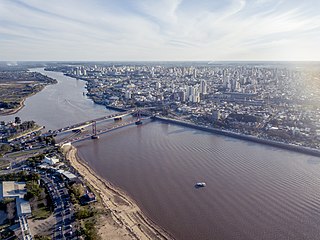
Rosario is the largest city in the central Argentine province of Santa Fe. The city, located 300 km (186 mi) northwest of Buenos Aires on the west bank of the Paraná River, is the third-most populous city in the country after Buenos Aires and Cordoba. With a growing and important metropolitan area, Greater Rosario has an estimated population of 1,750,000 as of 2020. One of its main attractions includes the neoclassical, Art Nouveau, and Art Deco architecture that has been preserved in hundreds of residences, houses and public buildings. The city is also famous for being the birthplace of the award-winning Argentine footballer Lionel Messi.
Santa Fe de la Vera Cruz is the capital city of the province of Santa Fe, Argentina. It is situated in north-eastern Argentina, near the junction of the Paraná and Salado rivers. It lies 15 kilometres (9.3 mi) from the Hernandarias Subfluvial Tunnel that connects it to the city of Paraná. The city is also connected by canal with the port of Colastiné on the Paraná River. Santa Fe de la Vera Cruz has about 391,164 inhabitants per the 2010 census [INDEC]. The metropolitan area has a population of 653,073, making it the eighth largest in Argentina.
Villa Constitución is a city in the province of Santa Fe, Argentina, and the head town of the Constitución Department. It is located on the south-western banks of the Paraná River between the courses of the Arroyo Pavón and the Arroyo del Medio, about 214 km south from the provincial capital, the city of Santa Fe, and 50 km from Rosario. It has a population of more than 47,374 inhabitants as per the 2010 census [INDEC].
The Raúl Uranga – Carlos Sylvestre Begnis Subfluvial Tunnel, formerly known as the Hernandarias Subfluvial Tunnel, is an underwater road tunnel that connects the provinces of Entre Ríos and Santa Fe in Argentina, crossing the Paraná River between the capital of Entre Ríos, Paraná, and Santa Cándida Island, 15 km from Santa Fe.
Rosario is the largest city of the province of Santa Fe, Argentina, and the third most populous in the country, after Córdoba and Buenos Aires. It is located about 300 km (190 mi) north of Buenos Aires, on the Western shore of the Paraná River, and it has about 910,000 inhabitants. It is surrounded by smaller cities and towns that form a metropolitan area with a population of about 1.2 million according to the 2001 census [INDEC].
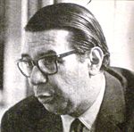
Carlos Sylvestre Begnis was a medical doctor and politician, born in Alto Grande, a village near Bell Ville, Córdoba province in Argentina. He was a rural physician and worked as a surgeon in hospitals of the city of Rosario, province of Santa Fe.
The following is an alphabetical list of topics related to the Argentina.
The Battle of Pavón, a key battle of the Argentine Civil Wars, was fought in Pavón, Santa Fé Province, Argentina on 17 September 1861 between the Army of the State of Buenos Aires and the Army of Republic of the Argentine Confederation. The withdrawal of Urquiza left the field to Mitre.
Mariano Vera was a caudillo and governor of the Santa Fe Province, United Provinces of the Rio de la Plata, between 12 April 1816 and 23 July 1818, all during a period of change driven by revolution and civil war in this portion of South America.
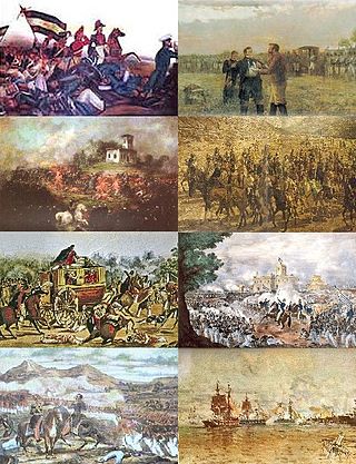
The Argentine Civil Wars were a series of civil conflicts of varying intensity that took place through the territories of Argentina from 1814 to 1853. Beginning concurrently with the Argentine War of Independence (1810–1818), the conflict prevented the formation of a stable governing body until the signing of the Argentine Constitution of 1853, followed by low-frequency skirmishes that ended with the Federalization of Buenos Aires in 1880.
Francisco Ramírez, also known as "Pancho" Ramírez as well as "El Supremo Entrerriano" (1786–1821), was an Argentine governor of Entre Ríos during the Argentine War of Independence.
The State of Buenos Aires was a secessionist republic resulting from the overthrow of the Argentine Confederation government in the Province of Buenos Aires on 11 September 1852. The State of Buenos Aires was never explicitly recognized by the Confederation; it remained, however, independent under its own government and constitution. Buenos Aires rejoined the Argentine Confederation after the former's victory at the Battle of Pavón in 1861.
Córdoba is a province of Argentina, located in the center of the country. Its neighboring provinces are Santiago del Estero, Santa Fe, Buenos Aires, La Pampa, San Luis, La Rioja, and Catamarca. Together with Santa Fe and Entre Ríos, the province is part of the economic and political association known as the Center Region.
Events from the year 1966 in Argentina.
Enrico Mosconi (1843-1910) was an Italian engineer and the father of the General Enrique Mosconi. He actively participated in the construction of the railways in the Argentine Republic.
The Argentine Revolution of 1893, or the Radical Revolution of 1893, was a failed insurrection by members of the Radical Civic Union (UCR) against the government of Argentina, then controlled by the National Autonomist Party (PAN). It continued the goals of the Revolution of the Park of 1890, whose themes were further echoed in the Revolution of 1905.
↑ Sir Woodbine Parish (1853), Buenos Aires y las provincias del Rio de la Plata: desde su descubrimiento y conquista por los Españoles, Tomo II, Buenos Aires: Imprenta de Mayo, pp, 14-15, La mayoría descendientes de inmigrantes de las Misiones jesuíticas guaraníes,
↑ Laura Marcela Méndez (2007), Las Efemérides En El Aula, Buenos Aires: Noveduc Libros, pp, 204, ISBN987-538-125-X,
↑ Mariela Ceva, Alejandro Fernández, Aníbal Jáuregui & Julio Stortini (2000), Historia Social Argentina En Documentos, Buenos Aires: Editorial Biblos, pp, 108, ISBN950-786-245-5,
This page is based on this Wikipedia article Text is available under the CC BY-SA 4.0 license; additional terms may apply. Images, videos and audio are available under their respective licenses.