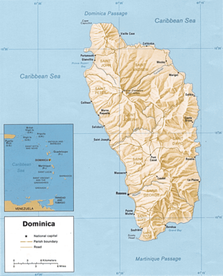
Dominica is an island in the Caribbean Sea, located about halfway between the French islands of Guadeloupe and Martinique. Its coordinates are 15 25 N, 61 20 W. It is known as "The Nature Island of the Caribbean" due to its spectacular, lush, and varied flora and fauna, which is protected by an extensive natural park system. It is the fourth largest island in the Eastern Caribbean with a population of people mainly of African descent.

Grenada is an island country located between the Caribbean Sea and Atlantic Ocean, north of Trinidad and Tobago. It is located at 12°07′N61°40′W. There are no large inland bodies of water on the island, which consists entirely of the state of Grenada. The coastline is 121 km long. The island has 15 constituencies and speaks English and Grenadian Creole. It is volcanic in origin and its topography is mountainous.
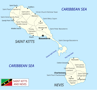
Saint Kitts and Nevis is a twin island country with a total landmass of just 270 square kilometres (104 sq mi). The island of St. Kitts, the larger of the two, is 180 square kilometres (68 sq mi) in size and is located at latitude 17.30 N, and longitude 62.80 W. Nevis is 93 square kilometres (36 sq mi) and located at latitude 17.10 N, longitude 62.35 W, approximately 3 km south-east of St. Kitts. The islands are about one-third of the way from Puerto Rico to Trinidad and Tobago. The islands are volcanic and mountainous.
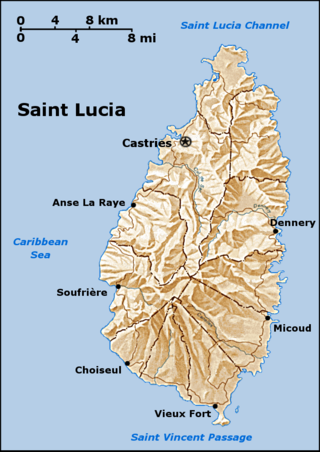
Saint Lucia is one of many small land masses composing the insular group known as the Windward Islands. Unlike large limestone areas such as Florida, Cuba, and the Yucatan Peninsula, or the Bahamas, which is a small island group composed of coral and sand, Saint Lucia is a typical Windward Island formation of volcanic rock that came into existence long after much of the region had already been formed.

Saint Vincent and the Grenadines is an island country in the eastern Caribbean. It is located in the southeast Windward Islands of the Lesser Antilles, which lie in the West Indies, at the southern end of the eastern border of the Caribbean Sea, where the latter meets the Atlantic Ocean.

The indigenous inhabitants of the islands of St. Vincent and the Grenadines were various Amerindian groups. The arrivals of Europeans in the early 16th century did not lead to long term settlement, only in 1717 did the French occupy the island in Barrouallie, though the English laid claim on St. Vincent in 1627. The Treaty of Paris (1763) saw St. Vincent ceded to Britain. Frictions with the British led to the First and Second Carib War in the mid- to late-18th century but the British held on to the islands. A Crown Colony government was installed in 1877, a Legislative Council created in 1925, and universal adult suffrage granted in 1951. Following a referendum in 1979, St. Vincent and the Grenadines became the last of the Windward Islands to gain independence on 27 October 1979.

Barbados is a continental island in the North Atlantic Ocean and is located at 13°10' north of the equator, and 59°32' west of the Prime Meridian. As the easternmost isle of the Lesser Antilles in the West Indies, Barbados lies 160 kilometres (100 mi) east of the Windward Islands and Caribbean Sea. The maritime claim for Barbados is a territorial sea of 12 nmi, with an exclusive economic zone of 200 nmi which gives Barbados a total maritime area of 186,898 km2 (72,162 sq mi). Of the total EEZ area, 70,000 km2 is set aside for offshore oil exploration. A pending application to UNCLOS has placed for consideration a continental shelf 200 nmi to the east and south. To the west, most of Barbados' maritime boundaries consist of median lines with neighbours. These neighbours include: Martinique, and Saint Lucia to the northwest, Saint Vincent and the Grenadines to the west, Trinidad and Tobago and Venezuela to the southwest, and Guyana to the southeast.

Saint Vincent is a volcanic island in the Caribbean. It is the largest island of the country Saint Vincent and the Grenadines and is located in the Caribbean Sea, between Saint Lucia and Grenada. It is composed of partially submerged volcanic mountains. Its largest volcano and the country's highest peak, La Soufrière, is active, with the latest episode of volcanic activity having begun in December 2020 and intensifying in April 2021.

Carriacou and Petite Martinique, also known as the Southern Grenadines, is a dependency (part) of Grenada, lying north of Grenada island and south of Saint Vincent and the Grenadines in the Lesser Antilles.

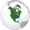
The Lesser Antilles are a group of islands in the Caribbean Sea. They are distinguished from the large islands of the Greater Antilles to the west. They form an arc which begins east of Puerto Rico and swings south through the Leeward and Windward Islands almost to South America and then turns west along the Venezuelan coast as far as Aruba. Barbados is isolated about 100 miles east of the Windwards.
The Windward Islands are the southern, generally larger islands of the Lesser Antilles. Part of the West Indies, they lie south of the Leeward Islands, approximately between latitudes 10° and 16° N and longitudes 60° and 62° W.

The Windward Islands cricket team is a cricket team representing the member countries of the Windward Islands Cricket Board of Control. The team plays in the West Indies Professional Cricket League under the franchise name Windward Islands Volcanoes.

The following outline is provided as an overview of and topical guide to Grenada:
The following outline is provided as an overview of and topical guide to Saint Vincent and the Grenadines:

Antigua and Barbuda lie in the eastern arc of the Leeward Islands of the Lesser Antilles, separating the Atlantic Ocean from the Caribbean Sea. Antigua is 650 km (400 mi) southeast of Puerto Rico; Barbuda lies 48 km (30 mi) due north of Antigua, and the uninhabited island of Redonda is 56 km (35 mi) southwest of Antigua.
Sir Robert Baxter Llewelyn (1845–1919) was a colonial administrator in the British Empire.