Geography of Guadeloupe

Last updated

Satellite photo of Guadeloupe Guadeloupe NASA 61.42577W 16.17142N.jpg
Satellite photo of Guadeloupe
Lush forest on Basse-Terre Panorama Chutes du Carbet.jpg
Lush forest on Basse-Terre
Detailed map of Guadeloupe Guadeloupe2021OSM.png
Detailed map of Guadeloupe

Guadeloupe is an archipelago of more than 12 islands, as well as islets and rocks situated where the northeastern Caribbean Sea meets the western Atlantic Ocean. [1] It is located in the Leeward Islands in the northern part of the Lesser Antilles, a partly volcanic island arc. To the north lie Antigua and Barbuda and the British Overseas Territory of Montserrat, with Dominica lying to the south.

Contents

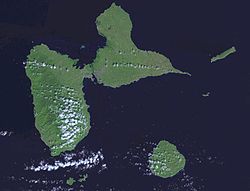
The two main islands are Basse-Terre (west) and Grande-Terre (east), which form a butterfly shape as viewed from above, the two 'wings' of which are separated by the Grand Cul-de-Sac Marin, Rivière Salée  [ fr ] and Petit Cul-de-Sac Marin. More than half of Guadeloupe's land surface consists of the 847.8 km2 Basse-Terre. [2] The island is mountainous, containing such peaks as Mount Sans Toucher (4,442 feet; 1,354 metres) and Grande Découverte (4,143 feet; 1,263 metres), culminating in the active volcano La Grande Soufrière, the highest mountain peak in the Lesser Antilles with an elevation of 1,467 metres (4,813 ft). [1] [3] In contrast Grande-Terre is mostly flat, with rocky coasts to the north, irregular hills at the centre, mangrove at the southwest, and white sand beaches sheltered by coral reefs along the southern shore. [3] This is where the main tourist resorts are found. [4]

Marie-Galante is the third-largest island, followed by La Désirade, a north-east slanted limestone plateau, the highest point of which is 275 metres (902 ft). To the south lies the Îles de Petite-Terre, which are two islands (Terre de Haut and Terre de Bas) totalling 2 km2. [4]

Les Saintes is an archipelago of eight islands of which two, Terre-de-Bas and Terre-de-Haut are inhabited. The landscape is similar to that of Basse-Terre, with volcanic hills and irregular shoreline with deep bays.

There are numerous other smaller islands, most notably Tête à l'Anglais, Îlet à Kahouanne, Îlet à Fajou, Îlet Macou, Îlet aux Foux, Îlets de Carénage, La Biche, Îlet Crabière, Îlets à Goyaves, Îlet à Cochons, Îlet à Boissard, Îlet à Chasse and Îlet du Gosier.

Geology

Basse-Terre is a volcanic island. [5] The Lesser Antilles are at the outer edge of the Caribbean Plate, and Guadeloupe is part of the outer arc of the Lesser Antilles Volcanic Arc. Many of the islands were formed as a result of the subduction of oceanic crust of the Atlantic Plate under the Caribbean Plate in the Lesser Antilles subduction zone. This process is ongoing and is responsible for volcanic and earthquake activity in the region. Guadeloupe was formed from multiple volcanoes, of which only La Grande Soufrière is not extinct. [6] Its last eruption was in 1976, and led to the evacuation of the southern part of Basse-Terre. 73,600 people were displaced throughout three and a half months following the eruption.

K–Ar dating indicates that the three northern massifs on Basse-Terre Island are 2.79 million years old. Sections of volcanoes collapsed and eroded within the last 650,000 years, after which the Sans Toucher volcano grew in the collapsed area. Volcanoes in the north of Basse-Terre Island mainly produced andesite and basaltic andesite. [7] There are several beaches of dark or "black" sand. [4]

La Désirade, east of the main islands, has a basement from the Mesozoic, overlaid with thick limestones from the Pliocene to Quaternary periods. [8]

Grande-Terre and Marie-Galante have basements probably composed of volcanic units of Eocene to Oligocene, but there are no visible outcrops. On Grande-Terre, the overlying carbonate platform is 120 metres thick. [8]

Climate

The islands are part of the Leeward Islands, so called because they are downwind of the prevailing trade winds, which blow out of the northeast. [1] [3] This was significant in the days of sailing ships. Grande-Terre is so named because it is on the eastern, or windward side, exposed to the Atlantic winds. Basse-Terre is so named because it is on the leeward south-west side and sheltered from the winds. Guadeloupe has a tropical climate tempered by maritime influences and the Trade Winds. There are two seasons, the dry season called "Lent" from January to June, and the wet season called "winter", from July to December. [1]

Climate data for Guadeloupe
MonthJanFebMarAprMayJunJulAugSepOctNovDecYear
Average high °C (°F)29.1
(84.4)
29.1
(84.4)
29.4
(84.9)
30.1
(86.2)
30.7
(87.3)
31.3
(88.3)
31.5
(88.7)
31.6
(88.9)
31.5
(88.7)
31.2
(88.2)
30.5
(86.9)
29.6
(85.3)
30.5
(86.9)
Daily mean °C (°F)24.5
(76.1)
24.5
(76.1)
24.9
(76.8)
25.9
(78.6)
26.9
(80.4)
27.5
(81.5)
27.6
(81.7)
27.7
(81.9)
27.4
(81.3)
27.0
(80.6)
26.3
(79.3)
25.2
(77.4)
26.3
(79.3)
Average low °C (°F)19.9
(67.8)
19.9
(67.8)
20.4
(68.7)
21.7
(71.1)
23.1
(73.6)
23.8
(74.8)
23.8
(74.8)
23.7
(74.7)
23.3
(73.9)
22.9
(73.2)
22.1
(71.8)
20.9
(69.6)
22.1
(71.8)
Average precipitation mm (inches)84
(3.3)
64
(2.5)
73
(2.9)
123
(4.8)
148
(5.8)
118
(4.6)
150
(5.9)
198
(7.8)
236
(9.3)
228
(9.0)
220
(8.7)
137
(5.4)
1,779
(70.0)
Average precipitation days15.011.511.511.613.612.815.416.216.618.116.615.7174.6
Mean monthly sunshine hours 235.6229.1232.5240.0244.9237.0244.9248.0216.0217.0207.0223.22,775.2
Source: Hong Kong Observatory [9]
Grande Anse Beach Plage de la Grande Anse a Deshaies 2.jpg
Grande Anse Beach

Tropical cyclones and storm surges

Located in a very exposed region, Guadeloupe and its dependencies have to face many cyclones. The deadliest hurricane to hit Guadeloupe was the Pointe-à-Pitre hurricane of 1776, which killed at least 6,000 people. [10]

On 16 September 1989, Hurricane Hugo caused severe damage to the islands of the archipelago and left a deep mark on the memory of the local inhabitants. In 1995, three hurricanes (Iris, Luis and Marilyn) hit the archipelago in less than three weeks.

Some of the deadliest hurricanes that have hit Guadeloupe are the following:

In the 20th century: 12 September 1928: 1928 Okeechobee hurricane; 11 August 1956: Hurricane Betsy; 22 August 1964: Hurricane Cleo; 27 September 1966: Hurricane Inez; 16–17 September 1989: Hurricane Hugo; 14–15 September 1995: Hurricane Marilyn.

In the 21st century: 6 September 2017: Hurricane Irma; 18–19 September 2017: Hurricane Maria.

Wildlife

Flora

The Guadeloupe woodpecker is endemic to the islands. Pic de la Guadeloupe.jpg
The Guadeloupe woodpecker is endemic to the islands.

With fertile volcanic soils, heavy rainfall and a warm climate, vegetation on Basse-Terre is lush. [2] Most of the islands' forests are on Basse-Terre, containing such species as mahogany, ironwood and chestnut trees. [1] Mangrove swamps line the Salée River. [1] Much of the forest on Grande-Terre has been cleared, with only a few small patches remaining. [1]

Between 300 and 1,000 m of altitude, the rainforest that covers a large part of the island of Basse-Terre develops. There we find the white gum tree, the acomat-boucan or chestnut tree, the marbri or bois-bandé or the oleander; shrubs and herbaceous plants such as the mountain palm, the balisier or ferns; many epiphytes: bromeliads, philodendrons, orchids and lianas. Above 1,000 m, the humid savannah develops, composed of mosses, lichens, sphagnum or more vigorous plants such as mountain mangrove, high altitude violet or mountain thyme.

The dry forest occupies a large part of the islands of Grande-Terre, Marie-Galante, Les Saintes, La Désirade and also develops on the leeward coast of Basse-Terre. The coastal forest is more difficult to develop because of the nature of the soil (sandy, rocky), salinity, sunshine and wind and is the environment where the sea grape, the mancenilla (a very toxic tree whose trunk is marked with a red line), the icaquier or the Coconut tree grow. On the cliffs and in the Arid zones are found cacti such as the cactus-cigar (Cereus), the prickly pear, the chestnut cactus, the "Tête à l'anglais" cactus and the aloes.

The Mangrove forest that borders some of Guadalupe's coasts is structured in three levels, from the closest to the sea to the farthest. On the first level are the red mangroves; on the second, about ten metres from the sea, the black mangroves form the shrubby mangrove; on the third level the white mangroves form the tall mangrove. Behind the mangrove, where the tide and salt do not penetrate, a swamp forest sometimes develops, unique in Guadeloupe. The representative species of this environment is the Mangrove-medaille.

The Jamaican fruit bat can be found throughout the department Artibeus jamaicensis.jpg
The Jamaican fruit bat can be found throughout the department

Fauna

Few terrestrial mammals, aside from bats and raccoons, are native to the islands. The introduced Javan mongoose is also present on Guadeloupe. [1] Bird species include the endemic purple-throated carib and the Guadeloupe woodpecker. [1] The waters of the islands support a rich variety of marine life. [1]

However, by studying 43,000 bone remains from six islands in the archipelago, 50 to 70% of snakes and lizards on the Guadeloupe Islands became extinct after European colonists arrived, who had brought with them mammals such as cats, mongooses, rats, and raccoons, which might have preyed upon the native reptiles. [11]

Environmental preservation

In recent decades, Guadeloupe's natural environments have been affected by hunting and fishing, forest retreat, urbanization and suburbanization. They also suffer from the development of intensive crops (banana and sugar cane, in particular), which reached their peak in the years 1955–75. This has led to the following situation: seagrass beds and reefs have degraded by up to 50% around the large islands; mangroves and mantids have almost disappeared in Marie-Galante, Les Saintes and La Désirade; the salinity of the fresh water table has increased due to "the intensity of use of the layer"; and pollution of agricultural origin (pesticides and nitrogenous compounds). [12]

In addition, the ChlEauTerre study, unveiled in March 2018, concludes that 37 different anthropogenic molecules (more than half of which come from residues of now-banned pesticides, such as chlordecone) were found in "79% of the watersheds analyzed in Grande-Terre and 84% in Basse-Terre." A report by the Guadeloupe Water Office notes that in 2019 there is a "generalized degradation of water bodies."

Despite everything, there is a will to preserve these environments whose vegetation and landscape are preserved in some parts of the islands and constitute a sensitive asset for tourism. These areas are partially protected and classified as ZNIEFF, sometimes with nature reserve status, and several caves are home to protected chiropterans.

La Soufriere Volcano crater and its fumaroles Sommet de la Soufriere.jpg
La Soufrière Volcano crater and its fumaroles

The Guadalupe National Park was created on 20 February 1989. In 1992, under the auspices of UNESCO, the Biosphere Reserve of the Guadeloupe Archipelago (Réserve de biosphère de l'archipel de la Guadeloupe) was created. As a result, on 8 December 1993, the marine site of Grand Cul-de-sac was listed as a wetland of international importance. [13] The island thus became the overseas department with the most protected areas.

Earthquakes and tsunamis

The archipelago is crossed by numerous geological faults such as those of la Barre or la Cadoue, while in depth, in front of Moule and La Désirade begins the Désirade Fault, and between the north of Maria-Galante and the south of Grande-Terre begins the Maria Galante Fault. And it is because of these geological characteristics, the islands of the department of Guadeloupe are classified in zone III according to the seismic zoning of France and are subject to a specific risk prevention plan. [14]

The 1843 earthquake in the Lesser Antilles is, to this day, the most violent earthquake known. It caused the death of more than a thousand people, as well as major damage in Pointe-à-Pitre.

On 21 November 2004, the islands of the department, in particular Les Saintes archipelago, were shaken by a violent earthquake that reached a magnitude of 6.3 on the Richter scale and caused the death of one person, as well as extensive material damage. [15]

See also

Related Research Articles

Guadeloupe Overseas department of France in the Caribbean

Guadeloupe is an archipelago and overseas department and region of France in the Caribbean. It consists of six inhabited islands—Basse-Terre, Grande-Terre, Marie-Galante, La Désirade, and the two inhabited Îles des Saintes—as well as many uninhabited islands and outcroppings. It is south of Antigua and Barbuda and Montserrat, north of the Commonwealth of Dominica. The region's capital city is Basse-Terre, located on the southern west coast of Basse-Terre Island; however, the most populous city is Les Abymes and the main centre of business is neighbouring Pointe-à-Pitre, both located on Grande-Terre Island. It had a population of 384,239 in 2019.

As an archipelago, Guadeloupe depends on several systems of public transport. The two islands that make up Guadeloupe proper - Grande-Terre and Basse-Terre - have an extensive road network, while water and air transportation connects to the outer islands as well as international destinations.

Lesser Antilles Archipelago in the Southeast Caribbean

The Lesser Antilles are a group of islands in the Caribbean Sea. Most of them are part of a long, partially volcanic island arc between the Greater Antilles to the north-west and the continent of South America. The islands of the Lesser Antilles form the eastern boundary of the Caribbean Sea where it meets the Atlantic Ocean. Together, the Lesser Antilles and the Greater Antilles make up the Antilles. The Lesser and Greater Antilles, together with the Lucayan Archipelago, are collectively known as the West Indies.

Baie-Mahault Commune in Guadeloupe, France

Baie-Mahault is a commune in the overseas department and region of Guadeloupe, France. It is the second most populated commune of Guadeloupe, after Les Abymes. The extensive industrial zone of Jarry in Baie-Mahault is by far the most industrialized commune in the islands and the largest industrial park in the Lesser Antilles. It is part of the urban area of Pointe-à-Pitre, the largest metropolitan area in Guadeloupe, located in the northwest.

Pointe-à-Pitre Subprefecture, commune, and the center of the largest metropolitan area in Guadeloupe

Pointe-à-Pitre is the second largest city of Guadeloupe after Les Abymes. Guadeloupe is an overseas region and department of France located in the Lesser Antilles, of which it is a sous-préfecture, being the seat of the Arrondissement of Pointe-à-Pitre.

Grande-Terre Eastern half of Guadeloupe

Grande-Terre Island is the name of the eastern-half of Guadeloupe proper, in the Lesser Antilles. It is separated from the other half of Guadeloupe island, Basse-Terre, by a narrow sea channel called Rivière Salée. Pointe de la Grande Vigie, in Grande-Terre, is the northernmost point of Guadeloupe island. To the east lies La Désirade, to the south lies Marie Galante

La Désirade Lighthouse

La Désirade is an island in the French West Indies, in the Lesser Antilles of the Caribbean. It forms part of Guadeloupe, an overseas region of France.

Marie-Galante

Marie-Galante is one of the islands that form Guadeloupe, an overseas department of France. Marie-Galante has a land area of 158.1 km2. It had 11,528 inhabitants at the start of 2013, but by the start of 2018 the total was officially estimated to be 10,655, with a population density of 62.5/km2 (162/sq mi).

Îles des Saintes Group of small islands in Basse-Terre, Trois-Rivières, Guadeloupe, overseas France

The Îles des Saintes, also known as Les Saintes, is a group of small islands in the archipelago of Guadeloupe, an overseas department of France. It is part of the Canton of Trois-Rivières and is divided into two communes: Terre-de-Haut and Terre-de-Bas. It is in the arrondissement of Basse-Terre and also in Guadeloupe's 4th constituency.

Terre-de-Bas Island

Terre-de-Bas Island is an island in the Îles des Saintes archipelago, in the Lesser Antilles.

Goyave Commune in Guadeloupe, France

Goyave is a commune in the French overseas region and department of Guadeloupe, Lesser Antilles. It is part of the urban area of Pointe-à-Pitre, the largest metropolitan area in Guadeloupe.

Guadeloupe woodpecker Species of bird

The Guadeloupe woodpecker or Tapeur is a species of bird in the woodpecker family Picidae belonging to the genus Melanerpes. Endemic to the Guadeloupe archipelago in the Lesser Antilles, it is a medium-sized forest woodpecker with entirely black plumage and red-to-purple reflections on its stomach. It lives mainly in the islands' tropical rainforest areas. The woodpecker has no sexual dimorphism. The species has adapted under the pressure of urbanization to more open forest environments.

Guadeloupe National Park French national park in Guadeloupe

Guadeloupe National Park is a national park in Guadeloupe, an overseas department of France located in the Leeward Islands of the eastern Caribbean region. The Grand Cul-de-Sac Marin Nature Reserve is a marine protected area adjacent to the park and administered in conjunction with it. Together, these protected areas comprise the Guadeloupe Archipelago biosphere reserve.

Index of Guadeloupe-related articles

Articles related to the French overseas department of Guadeloupe include:

The saintoise or canot saintois is a fishing boat without a deck, traditionally maneuverable with the sail or the ream. It is native to the les Saintes archipelago where it spread throughout the Lesser Antilles. The saintoise is an integral part of the heritage and the cultural identity of the archipelago. The practice of using sailing saintoises developed quickly in Guadeloupean water sports since 2001 when it officially became a new sport, the traditional sailboat racing.

Îlet à Cabrit

Îlet à Cabrit is an island in the Îles des Saintes archipelago, in the Lesser Antilles. It belongs to the commune (municipality) of Terre-de-Haut into the French department of Guadeloupe.

Grand-Îlet

Grand-Îlet is an island in the Îles des Saintes archipelago, in the Lesser Antilles. It belongs to the commune (municipality) of Terre-de-Haut into the French department of Guadeloupe.

La Désirade National Nature Reserve

La Désirade National Nature Reserve is a reserve in Désirade Island in Guadeloupe. Established under the Ministerial Decree No. 2011-853 of 19 July 2011 for its special geological features it has an area of 62 ha. The reserve represents the geological heritage of the Caribbean tectonic plate, with a wide spectrum of rock formations, the outcrops of volcanic activity being remnants of the sea level oscillations. It is one of thirty three geosites of Guadeloupe.

Leeward Islands xeric scrub Xeric shrubland ecoregion of the Leeward Islands

The Leeward Islands xeric scrub ecoregion covers the dry ('xeric'), non-forested areas of the Leeward Islands on the northeastern edge of the Caribbean Sea, stretching from the Virgin Islands in the west to Guadeloupe to the southeast. The non-forested areas are generally low scrub shrub, on the low elevations around the peripheries of the islands. Non-forested lower elevations in the region receive less rainfall and are typically semi-arid. A notable feature of the ecoregion is its position in the main hurricane track. The frequent damage to trees allows more pre-climax shrubs and trees to grow. There are a number of endemic species, as in common with islands.

References

  1. 1 2 3 4 5 6 7 8 9 10 "Encyclopedia Britannica – Guadeloupe" . Retrieved 27 July 2019.
  2. 1 2 "Guadeloupe". Encyclopedia Britannica. Retrieved 12 December 2018.
  3. 1 2 3 "CIA World Factbook (2006) – Guadeloupe" . Retrieved 27 July 2019.
  4. 1 2 3 "Geography and geology". Le Guide Guadeloupe. Archived from the original on 18 April 2019. Retrieved 17 April 2019.
  5. Mathieu, Lucie; van Wyk de Vries, Benjamin; Mannessiez, Claire; Mazzoni, Nelly; Savry, Cécile; Troll, Valentin R. (5 March 2013). "The structure and morphology of the Basse Terre Island, Lesser Antilles volcanic arc". Bulletin of Volcanology. 75 (3): 700. Bibcode:2013BVol...75..700M. doi:10.1007/s00445-013-0700-y. ISSN   1432-0819. S2CID   129467145.
  6. "Guadeloupe" (PDF). Institut de physique du globe de Paris. Universite de Paris. Retrieved 17 April 2019.
  7. Samper, A.; Quidelleur, X.; Lahitte, P.; Mollex, D. (2007). "Timing of effusive volcanism and collapse events within an oceanic arc island: Basse-Terre, Guadeloupe archipelago (Lesser Antilles Arc)". Earth and Planetary Science Letters. 258 (1–2): 175–191. Bibcode:2007E&PSL.258..175S. doi:10.1016/j.epsl.2007.03.030.
  8. 1 2 Bourdon, E; Bouchot, V; Gadalia, A; Sanjuan, B. "Geology and geothermal activity of the Bouillante Volcanic Chain" (PDF). Archived from the original (PDF) on 19 April 2019. Retrieved 18 April 2019.
  9. "Climatological Information for Guadeloupe". Archived from the original on 3 April 2012.
  10. "The Deadliest Atlantic Tropical Cyclones, 1492–1996". www.nhc.noaa.gov. Retrieved 10 June 2021.
  11. Corentin Bochaton; et al. (2021). "Large-scale reptile extinctions following European colonization of the Guadeloupe Islands". Vol. 7, no. 21. Science Advances. doi:10.1126/sciadv.abg2111.
  12. Un rapport s’alarme de « la dégradation généralisée » des masses d’eau en Guadeloupe, Le Monde.fr, 10 septembre 2019
  13. "Grand Cul-de-Sac Marin de la Guadeloupe | Service d'information sur les Sites Ramsar". rsis.ramsar.org. Retrieved 10 June 2021.
  14. Guadeloupe, DEAL de (26 November 2014). "Les plans de prévention des risques naturels – Présentation générale". www.guadeloupe.developpement-durable.gouv.fr (in French). Retrieved 10 June 2021.
  15. "Séisme ressenti en Guadeloupe". LEFIGARO (in French). 16 March 2011. Retrieved 10 June 2021.