Geography of Saint Lucia

Last updated
Saint Lucia
Nickname: Helen of the West Indies
Saint Lucia geography map en.png
Map of Saint Lucia
Karibik St Lucia Position.png
Geography
Location Caribbean Sea, Atlantic Ocean
Coordinates 13°53′N60°58′W / 13.883°N 60.967°W / 13.883; -60.967 (Saint Lucia)
Archipelago Windward Islands
Area616 km2 (238 sq mi)
Coastline158 km (98.2 mi)
Highest elevation950 m (3120 ft)
Highest point Mount Gimie
Administration
Saint Lucia
District10
Largest settlement Castries (pop. 10,634)
Demographics
Population160,765 (2005)
Pop. density260.98/km2 (675.94/sq mi)
Ethnic groups African 82.5%, Mulatto 11.9%, East Indian 2.4%, White 1.0%, Other or unspecified 3.1%
Map of Saint Lucia St Lucia map.png
Map of Saint Lucia
Enlargeable, detailed map of Saint Lucia SaintLucia2021OSM.png
Enlargeable, detailed map of Saint Lucia

Saint Lucia is one of many small land masses composing the insular group known as the Windward Islands. [1] Unlike large limestone areas such as Florida, Cuba, and the Yucatan Peninsula, or the Bahamas, which is a small island group composed of coral and sand, Saint Lucia is a typical Windward Island formation of volcanic rock that came into existence long after much of the region had already been formed. [1]

Contents

Saint Lucia's physical features are notable. [1] Dominated by high peaks and rain forests in the interior, the 616-square-kilometer (238-square-mile) island is known for the twin peaks of Gros Piton ( 13°48′36″N61°04′03″W / 13.81013°N 61.06753°W / 13.81013; -61.06753 (Gros Piton) )and Petit Piton ( 13°49′59″N61°03′49″W / 13.83308°N 61.0635°W / 13.83308; -61.0635 (Petit Piton) ) on the southwestern coast, its soft sandy beaches, and its magnificent natural harbours. [1] Mount Gimie, the highest peak, is located in the central mountain range and rises to 958 meters (3,143 ft) above sea level, a contrast that is also evident in the abrupt climatic transition from coastal to inland areas. [1] The steep terrain also accentuates the many rivers that flow from central Saint Lucia to the Caribbean. [1] Fertile land holdings, which support banana farming, are scattered throughout the island. [1]

Saint Lucia has a tropical, humid climate moderated by northeast trade winds that allow for pleasant year-round conditions. [1] Mean annual temperatures range from 26 °C (78.8 °F) to 32 °C (89.6 °F) at sea level and drop to an average of 13 °C (55.4 °F) in the mountain peaks. [1] The abundant annual rainfall accumulates to approximately 2,000 millimeters (78.7 in), with most precipitation occurring during the June to December wet season. [1] Hurricanes are the most severe climatic disturbance in this area and have been known to cause extensive damage. [1] Although Saint Lucia has historically been spared from serious hurricane destruction, Hurricane Allen decimated the agricultural sector and claimed nine lives in 1980. [1] More recently, in 2010, Hurricane Tomas claimed seven lives and also caused extensive agricultural damage, particularly to the island's burgeoning cocoa crop.

General

Saint Lucia is in the Caribbean, an island between the Caribbean Sea and North Atlantic Ocean, north of Saint Vincent and north-west of Barbados. The capital city of Saint Lucia is Castries, where about one third of the population lives. Major towns include Gros Islet, Soufrière and Vieux Fort.

Measurements

Maritime claims

Climate

Saint Lucia is in the tropical zone, although its climate is moderated by northeast trade winds. Since it is fairly close to the equator, and the surrounding sea surface temperature only fluctuates 3°C (25-28°C) the coastal air temperature does not fluctuate much between winter and summer. The dry season is from December to June, and the rainy season is from June to November. Average daytime temperatures are around 30 °C (86.0 °F), and average night time temperatures are around 24 °C (75.2 °F). Average annual rainfall ranges from 1,300 mm (51.2 in) on the coast to 3,810 mm (150 in) in the mountain rainforests.

Climate data for St Lucia
MonthJanFebMarAprMayJunJulAugSepOctNovDecYear
Mean daily maximum °C (°F)29
(84)
29
(84)
29
(84)
30
(86)
31
(88)
31
(88)
31
(88)
31
(88)
31
(88)
31
(88)
30
(86)
29
(84)
30
(86)
Daily mean °C (°F)26
(79)
26
(79)
26
(79)
27
(81)
28
(82)
28
(82)
28
(82)
28
(82)
28
(82)
28
(82)
27
(81)
26
(79)
27
(81)
Mean daily minimum °C (°F)23
(73)
23
(73)
24
(75)
24
(75)
25
(77)
25
(77)
25
(77)
25
(77)
25
(77)
25
(77)
24
(75)
24
(75)
24
(76)
Average precipitation mm (inches)125
(4.9)
95
(3.7)
75
(3.0)
90
(3.5)
125
(4.9)
200
(7.9)
245
(9.6)
205
(8.1)
225
(8.9)
260
(10.2)
215
(8.5)
160
(6.3)
2,020
(79.5)
Average precipitation days14910101115181617201816174
Mean monthly sunshine hours 2482262482402482402482482402172402482,891
Source: climatestotravel [2]

Terrain

Volcanic and mountainous with some broad, fertile valleys.

Extreme points

Natural resources

Saint Lucia has forests, sandy beaches, minerals (pumice), mineral springs, and a geothermal potential. [3]

Land use

About 18% of the land is used for agricultural practices. Most farms consist of less than 5 acres of land. The main agricultural products grown in Saint Lucia are bananas, coconuts, cocoa beans, mangoes, avocados, vegetables, citrus fruits, and root crops such as yams and sweet potatoes. Most of these agricultural products are grown for local consumption, but bananas and coconuts are mainly grown for export, with some vegetables. Bananas occupy about 14,826 acres of the agricultural land, while coconuts occupy 12,400 acres.

Saint Lucia Land Usage as of 2018 [3]
TypePercentArea
Total Agricultural Land17.4107.2 km2 (41.4 sq mi)
- arable land4.930.2 km2 (11.7 sq mi)
- permanent crops11.570.8 km2 (27.3 sq mi)
- permanent pasture1.06.2 km2 (2.4 sq mi)
- irrigated land230 km2 (12 sq mi)
(2012 est.)
Forests and woodland77.0474.3 km2 (183.1 sq mi)
Other5.634.5 km2 (13.3 sq mi)

Forest reserves and botanical gardens in Saint Lucia:

Diamond Falls at Diamond Botanical Gardens Diamond Falls, Diamond Botanical Gardens, Soufriere, Saint Lucia.jpg
Diamond Falls at Diamond Botanical Gardens

Islands

The island of the island nation of Saint Lucia include the following: [4]

Districts

Districts of Saint Lucia and the forest reserve Sainte-Lucie - districts numerotes.png
Districts of Saint Lucia and the forest reserve

The island of Saint Lucia is divided into 10 Districts and the Forest Reserve:

  1. Anse la Raye, Leeward Caribbean Sea
  2. Canaries, Leeward Caribbean Sea
  3. Castries, Leeward Caribbean Sea
  4. Choiseul, Leeward Caribbean Sea
  5. Dennery, Windward Atlantic Ocean
  6. Grand Bois Forest Reserve, Internal (entrance at 13°55′31″N61°00′33″W / 13.92541°N 61.0093°W / 13.92541; -61.0093 (Grand Bois Forest Reserve entrance) )
  7. Gros Islet, Leeward Caribbean Sea, Windward Atlantic Ocean
  8. Laborie, Leeward Caribbean Sea
  9. Micoud, Windward Atlantic Ocean
  10. Soufrière, Leeward Caribbean Sea
  11. Vieux Fort, Windward Atlantic Ocean, Leeward Caribbean Sea

Natural hazards

The island country of Saint Lucia is effected by hurricanes and volcanic activity. The island was severely affected by Hurricane Allen in 1980 and Hurricane Tomas in 2010, causing agricultural damage and a drop in visitor arrivals, but Saint Lucia has generally had fewer hurricanes than many other Caribbean islands, due to its southerly location. Hurricanes and volcanoes would both damage the coral. [5]

Environment

Sulphur Springs,
13deg50'16''N 61deg02'44''W / 13.8378degN 61.04568degW / 13.8378; -61.04568 (Sulphur Springs) Sulfur spring st lucia.JPG
Sulphur Springs, 13°50′16″N61°02′44″W / 13.8378°N 61.04568°W / 13.8378; -61.04568 (Sulphur Springs)

Current issues include deforestation and soil erosion, particularly in the northern region.

Saint Lucia is party to the following treaties and conventions:

See also

Related Research Articles

<span class="mw-page-title-main">Geography of Dominica</span> Geography of the island country of Dominica

Dominica is an island in the Caribbean Sea, located about halfway between the French islands of Guadeloupe and Martinique. Its coordinates are 15 25 N, 61 20 W. It is known as "The Nature Island of the Caribbean" due to its spectacular, lush, and varied flora and fauna, which is protected by an extensive natural park system. It is the fourth largest island in the Eastern Caribbean with a population of people mainly of African descent.
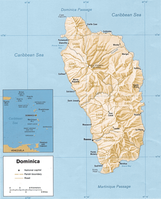
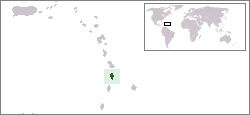
<span class="mw-page-title-main">Saint Lucia</span> Country in the West Indies in the eastern Caribbean Sea

Saint Lucia is a constitutional monarchy and an island country of the West Indies in the eastern Caribbean. The island was previously called Iouanalao and later Hewanorra, names given by the native Arawaks and Caribs (respectively), two Amerindian peoples. Part of the Windward Islands of the Lesser Antilles, it is located north/northeast of the island of Saint Vincent, northwest of Barbados and south of Martinique. It covers a land area of 617 km2 with an estimated population of over 180,000 people as of 2018. The nation's capital and largest city is Castries.

<span class="mw-page-title-main">Geography of Saint Vincent and the Grenadines</span>

Saint Vincent and the Grenadines is an island state in the Windward Islands of the Lesser Antilles, an island arc of the Caribbean Sea in North America. The country consists of the main island of Saint Vincent and the northern two-thirds of the Grenadines, a chain of small islands stretching south from Saint Vincent to Grenada. Its total land area is 390 km2 of which 342.7 km2 is the main island of Saint Vincent. The country's capital is at Kingstown on Saint Vincent.

The Windward Islands are the southern, generally larger islands of the Lesser Antilles. Part of the West Indies, they lie south of the Leeward Islands, approximately between latitudes 10° and 16° N and longitudes 60° and 62° W.

<span class="mw-page-title-main">Gros Islet District</span> District in St. Lucia

Gros Islet District, one of 10 first order subdivision of the Caribbean island nation of Saint Lucia which includes the island's northernmost point, Cap Point and the notable Cap Estate, where the renowned St. Lucia Golf and Country Club is located. Whilst the town of Gros Islet is an important administrative centre, Rodney Bay is the main financial center of the district.

<span class="mw-page-title-main">Soufrière District</span> Districts in St. Lucia

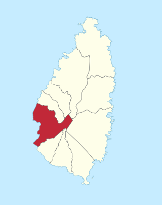
Soufrière is a district on the Southwest coast of Saint Lucia in the West Indies. Soufrière was the former capital of Saint Lucia during times of French rule. It is now a small fishing port with an emerging tourism industry. It has several tourist sites, including a "drive-in" volcano, the Diamond Botanical Gardens with waterfall and historic mineral baths, plus the nearby beaches of Anse Chastanet to the north and Malgretout to the south.

<span class="mw-page-title-main">Dennery District</span> Quarter and town in St. Lucia

Dennery District is one of 10 districts of the Caribbean island nation of Saint Lucia. The seat of Dennery District is the Dennery Village. The main economic activities are fishing, and the cultivation of lima beans, bananas, and other tropical fruit. The population of the quarter was estimated at 12,876 in 2002 and fell to 12,767 in 2010.

<span class="mw-page-title-main">Districts of Saint Lucia</span> First-level administrative divisions of Saint Lucia

The island nation of Saint Lucia is divided into 10 districts. The name Quarters or Quartiers originally came from the French period in Saint Lucia. The 2001 and 2010 Census of Saint Lucia refers to the first level administrative divisions as districts. The FIPS and ISO standards regularly called these divisions quarters or quartiers in French. The former district of Dauphin Quarter was merged into Gros Islet District and the former district of Praslin Quarter was merged into Micoud District.

<span class="mw-page-title-main">Pitons (Saint Lucia)</span> Mountainous volcanic plug in Saint Lucia

The Pitons are two mountainous volcanic plugs, volcanic spires, located in Saint Lucia. Petit Piton is 743 m (2,438 ft) high and Gros Piton is 798.25 m (2,618.9 ft) high; they are linked by the Piton Mitan ridge. The Pitons are a World Heritage Site, 2,909 ha in size, and located near the town of Soufrière.

<span class="mw-page-title-main">Micoud District</span> District in St. Lucia

Micoud District is one of 10 districts of the Caribbean island nation of Saint Lucia The seat of this district is the town of Micoud inside this district. According to the 2002 census, the population of the district was 16,143 people. The final 2010 Census recorded a population of 16,284 in Micoud District. A former quarter, Praslin Quarter, was merged into Micoud Quarter. It was not enumerated separately in the 2010 Census. The 2001 Census shows Praslin as part of Micoud District.

<span class="mw-page-title-main">Windward Islands cricket team</span>

The Windward Islands cricket team is a cricket team representing the member countries of the Windward Islands Cricket Board of Control. The team plays in the West Indies Professional Cricket League under the franchise name Windward Islands Volcanoes.

<span class="mw-page-title-main">Roman Catholic Archdiocese of Castries</span> Latin Catholic ecclesiastical jurisdiction in the Caribbean

The Metropolitan Archdiocese of Castries is an archdiocese of the Latin Church of the Catholic Church in the Caribbean. The archdiocese consists of the entirety of the former British dependency of Saint Lucia and is a metropolitan see, the suffragans of the Castries Province being the Dioceses of Roseau, Saint George's in Grenada, St. John's-Basseterre and Kingstown. The archdiocese is a member of the Antilles Episcopal Conference.

<span class="mw-page-title-main">Marigot Bay</span> Body of water in Saint Lucia

Marigot Bay is located on the western coast of the Caribbean island country of Saint Lucia, 3.75 miles southwest from Castries and a short distance from the Saint Lucian National Marine Reserve. It is surrounded on three sides by steep, forested hills.

<span class="mw-page-title-main">Tourism in Saint Lucia</span> Saint Lucia Tourism

Saint Lucia, an island nation in the Caribbean islands, has a relatively large tourism industry. Due to the relatively small land area of the country, most of the governmental promotion is performed by the state-operated Saint Lucia Tourism Authority, led by Executive Chairperson Agnes.

<span class="mw-page-title-main">Index of Saint Lucia–related articles</span>

The following is an alphabetical list of topics related to the nation of Saint Lucia.

<span class="mw-page-title-main">Soufrière, Saint Lucia</span> Town in Soufrière Quarter, Saint Lucia

Soufrière is a town on the West Coast of Saint Lucia, in the eastern Caribbean Sea. The town and the surrounding district has a population of 7,935. It was colonized by the French and was the original capital of the island.

<span class="mw-page-title-main">Canaries District</span> Quarter or district of the island nation of Saint Lucia

Canaries District is one of 10 districts of the island nation of St. Lucia in the Caribbean Sea. In 2010, the population of the region was 2,009 people, and they are mainly fishers and agricultural workers. The main town in the area takes the same name as the district and is located down the western coast from Castries, the capital of the country. It is the smallest quarter of Saint Lucia, both by population and area.

<span class="mw-page-title-main">Qualibou</span>

Qualibou, also known as the Soufrière Volcanic Center, is a 3.5 × 5 km-wide caldera on the island of Saint Lucia that formed between 32,000 and 39,000 years ago. This eruption also formed the Choiseul Tuff which covers the southeastern portion of the island.

References

  1. 1 2 3 4 5 6 7 8 9 10 11 12 Meditz, Sandra W.; Hanratty, Dennis M., eds. (1987). "Saint Lucia: Geography". Islands of the Commonwealth Caribbean: a regional study. Washington, D.C.: Federal Research Division, Library of Congress. p. 294-295. OCLC   49361510.
  2. "St Lucia climate". Climates to travel. Retrieved 14 November 2018.
  3. 1 2 "CIA Factobook, Saint Lucia". Central Intelligence Agency. Retrieved August 22, 2021.
  4. "Islads of Saint Lucia". GeoName. Retrieved August 21, 2021.
  5. "Saint Lucia Hurricanes". Hurricane City. Retrieved August 22, 2021.