Gros Islet

Last updated
Gros Islet
At the top of Pigeon Island.jpg
Gros Islet and Rodney Bay as seen from Pigeon Island
Santa lucia gros islet political.png
The District of Gros Islet, with the town of Gros Islet marked in red
Coordinates: 14°04′52″N60°57′11″W / 14.081°N 60.953°W / 14.081; -60.953 Coordinates: 14°04′52″N60°57′11″W / 14.081°N 60.953°W / 14.081; -60.953
CountryFlag of Saint Lucia.svg  Saint Lucia
Quarter Gros Islet Quarter
Founded1749?
Founded by France
Government
  Governing bodyGros Islet Town Council
Area
  Total101.528 km2 (39.2 sq mi)
Elevation
[1]
2 m (6 ft)
Population
 (2005) [2]
  Total21,660 (Gros Islet District)
Time zone UTC-4 (Eastern Caribbean Time Zone (ECT))
Area code 758

Gros Islet (English: Large Island) is a community near the northern tip of the island country of Saint Lucia, in the Gros Islet Quarter. Originally a quiet fishing village, it has become one of the more popular tourist destinations in the country. [3]

Contents

History

Originally settled by the Carib (and possibly Arawak), the area was first identified as Gros Islet in a French map from 1717. [4] The community was a Roman Catholic parish, and the first priests who arrived on the island settled in the village in 1749. [5]

In 1778, the Anglo-French War broke out between France and Great Britain. As part of the conflict, the British Royal Navy captured the island of Saint Lucia and built a naval base at Gros Islet Bay in 1782, temporarily changing the name to Fort Rodney. The island has changed hands between the British and French throughout its existence.

Between 1991 and 2001, the population rose 54%; [6] the biggest increase in the country. In 2001, the population of Gros Islet was 19,409, making it the second-most populous community in Saint Lucia, up from 13,505 in the 1991 census and 10,164 in the 1980 census. [6] Of that number, 9,307 were male and 10,102 were female. [6]

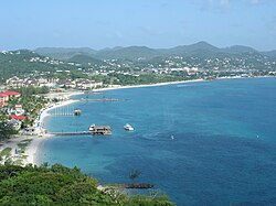
A nearby mangrove swamp was dredged to form Rodney Bay Marina, and many hotels, resorts, and villas have since been built. However, the old village of Gros Islet is still a flourishing district.

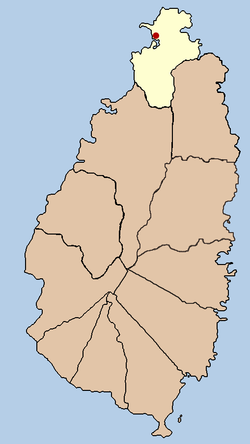
In September 2011, the parliamentary representative for the area, the Honourable Lenard Montoute, advised that the constituency might become St. Lucia's second city, if the expansion plans for the area progress in accordance with its development blueprint. [7]

See also

Related Research Articles

<span class="mw-page-title-main">Saint Lucia</span> Country in the West Indies in the eastern Caribbean Sea

Saint Lucia is an island country of the West Indies in the eastern Caribbean. The island was previously called Iouanalao and later Hewanorra, names given by the native Arawaks and Caribs, two Amerindian peoples. Part of the Windward Islands of the Lesser Antilles, it is located north/northeast of the island of Saint Vincent, northwest of Barbados and south of Martinique. It covers a land area of 617 km2 with an estimated population of over 180,000 people as of 2022. The national capital is the city of Castries.

<span class="mw-page-title-main">Geography of Saint Lucia</span> Geography of the island country Saint Lucia

Saint Lucia is one of many small land masses composing the insular group known as the Windward Islands. Unlike large limestone areas such as Florida, Cuba, and the Yucatan Peninsula, or the Bahamas, which is a small island group composed of coral and sand, St. Lucia is a typical Windward Island formation of volcanic rock that came into existence long after much of the region had already been formed.

<span class="mw-page-title-main">Castries</span> Capital of Saint Lucia

Castries is the capital and largest city of Saint Lucia, an island country in the Caribbean. The urban area has a population of approximately 20,000, while the eponymous district has a population of 70,000, as at May 2013. The city stretches over an area of 80 km2 (31 sq mi).

<span class="mw-page-title-main">Grand Manan</span> Village in New Brunswick, Canada

Grand Manan is a Canadian island in the Bay of Fundy. Grand Manan is also the name of an incorporated village, which includes the main island and all of its adjacent islands, except White Head Island. It is governed as a village and is part of the province of New Brunswick.

<span class="mw-page-title-main">Gros Islet District</span> District in St. Lucia

Gros Islet District, one of 10 first order subdivision of the Caribbean island nation of Saint Lucia which includes the island's northernmost point, Cap Point and the notable Cap Estate, where the renowned St. Lucia Golf and Country Club is located. Whilst the town of Gros Islet is an important administrative centre, Rodney Bay is the main financial center of the district.

<span class="mw-page-title-main">Districts of Saint Lucia</span> First-level administrative divisions of Saint Lucia

The island nation of Saint Lucia is divided into 10 districts. The name Quarters or Quartiers originally came from the French period in Saint Lucia. The 2001 and 2010 Census of Saint Lucia refers to the first level administrative divisions as districts. The FIPS and ISO standards regularly called these divisions quarters or quartiers in French. The former district of Dauphin Quarter was merged into Gros Islet District and the former district of Praslin Quarter was merged into Micoud District.

<span class="mw-page-title-main">Choiseul District</span> District in St. Lucia

Choiseul District is one of the 10 districts of the Caribbean island nation of Saint Lucia. Located on the southwestern side of the island, the district is home to 6,130 people, according to the 2019 census. The seat of Choiseul District is the town of Choiseul.

<span class="mw-page-title-main">Daren Sammy Cricket Ground</span> Cricket ground

The Daren Sammy Cricket Ground, previously the Beausejour Cricket Ground, is a cricket ground located near Gros Islet, Saint Lucia standard seating capacity of 15,000. It was completed in 2002 and currently accommodates 13,000 spectators.

<span class="mw-page-title-main">Gros-Mécatina, Quebec</span> Municipality in Quebec, Canada

Gros-Mécatina is a municipality on the Lower North Shore of the Gulf of Saint Lawrence, near the border with Labrador in Quebec, Canada. Located near crab, lobster, and scallop fishing grounds, it is dependent on the fishing business, including a fish processing factory that contributes to regional economic activity.

<span class="mw-page-title-main">Choiseul, Saint Lucia</span> Place in Choiseul District, Saint Lucia

Choiseul was originally known as Anse Citron, and an independent parish was established in 1765. In 1769 a census was done and recorded 75 whites, 25 free coloured, 512 negroes and 69 estates in Choiseul. However, most activity was originally in the River Dorée area, south-east of Choiseul.

<span class="mw-page-title-main">Cloridorme, Quebec</span> Township municipality in Quebec, Canada

Cloridorme is a township municipality in the Gaspé Peninsula, Quebec, Canada. Cloridorme's economy is centred on fishing. Its population, according to the 2016 Canadian Census was 671. The township stretches for 16 kilometres (10 mi) along the Gulf of Saint Lawrence and includes Cloridorme Bay where the Little and Great Cloridorme Rivers have their mouths.

<span class="mw-page-title-main">Pigeon Island (Saint Lucia)</span> Islet in Saint Lucia; home to the 18th century fortification Fort Rodney

Pigeon Island is a 44-acre (180,000 m2) islet located in Gros Islet in the northern region of Saint Lucia. Once isolated from the country in the Caribbean Sea, the island was artificially joined to the western coast of mainland in 1972 by a man-made causeway built from dirt excavated to form the Rodney Bay Marina. Composed of two peaks the island is a historic site with numerous forts such as an 18th-century British fort and Fort Rodney both used by the British to spy on French Ships from neighbouring Martinique. In 1979 it was named a national park and again in 1992 it became a national landmark under the control of the Saint Lucia National Trust (SLNT). Today, Pigeon Island is the home and major venue of the Saint Lucia Jazz Festival.

<span class="mw-page-title-main">Babonneau</span> Region and electoral district of Saint Lucia

Babonneau is one of the regions of the Caribbean island nation of Saint Lucia. Babonneau is located in the north of the island in the Castries Quarter. There are extensive rain forests in the region, which is an important source of fresh water for Saint Lucia. Babonneau is also an electoral constituency of Saint Lucia represented in the House of Assembly of Saint Lucia, which extends into Gros Islet District.

<span class="mw-page-title-main">Tourism in Saint Lucia</span> Saint Lucia Tourism

Saint Lucia, an island nation in the Caribbean islands, has a relatively large and lucrative tourism industry. Due to the relatively small land area of the country, most of the governmental promotion is performed by the state-operated Saint Lucia Tourism Authority, led by Executive Chairperson Agnes.

<span class="mw-page-title-main">Rodney Bay</span> Bay in Gros Islet Quarter, Saint Lucia

Rodney Bay is a town and bay located in the Gros Islet District on the island of Saint Lucia. Gros Islet is one of the ten districts in the island. It can be found on the northwestern coast of the island above the Castries District, where the capital of St. Lucia is, and the former Dauphin quarter. St. Lucia is a small island in North America located in the Caribbean Sea and it is the largest of the Caribbean's Windward Islands. The Windward islands include Martinique, Saint Vincent and the Grenadines, Barbados, Trinidad and Tobago and Grenada. It is in a chain of islands in the Lesser Antilles with Martinique to the north and Saint Vincent and the Grenadines to the south. These islands are southeast of the islands of Puerto Rico and Haiti. Out of the two airports in St.Lucia, Hewanorra and Charles airport, Rodney Bay is closer to the latter.

<span class="mw-page-title-main">Outline of Saint Lucia</span> Overview of and topical guide to Saint Lucia

The following outline is provided as an overview of and topical guide to Saint Lucia:

<span class="mw-page-title-main">Soufrière, Saint Lucia</span> Town in Soufrière Quarter, Saint Lucia

Soufrière is a town on the West Coast of Saint Lucia, in the eastern Caribbean Sea. The town and the surrounding district has a population of 7,935. It was colonized by the French and was the original capital of the island.

<span class="mw-page-title-main">Invasion of Tobago</span>

The Invasion of Tobago was a French invasion of the British-held island of Tobago during the Anglo-French War. On May 24, 1781, the fleet of Comte de Grasse landed troops on the island under the command of General Marquis de Bouillé. By June 2, 1781, they had successfully gained control of the island.

Saltibus is located on southwestern side of the Island of Saint Lucia. It belongs to one of two of the 11 quarters, or sections of the island, which were sometimes called "districts", which is no longer under control of the British colonial government as of 1979 AD. The village Saltibus is located northeast of the village of Choiseul, and northwest of the village of Laborie. It is located about 27 km south of Castries, the nation's capital. Saltibus is located in a rain-forest and is well known for its fresh running water and its rich fertile soil. There are a series of waterfalls with heights from 3 to 10 meters in the rain-forest. You could also find many rivers, cold springs and fresh stream. Saltibus has the main water dam which supplies water to the community and several neighboring communities. The economy is largely based on agriculture, in the form of bananas, cocoa, and other tropical produce.

References

  1. "Weather in Gros Islet. Current weather | lc.freemeteo.com". lc.freemeteo.com.
  2. Mawer, Fred (2016-02-05). "Where to drink in St Lucia, from swish bars to street parties". The Telegraph. ISSN   0307-1235 . Retrieved 2020-08-03.
  3. Luntta, K: The Rough Guide to St Lucia, page 82
  4. "Gros-Islet Parish Website". Archived from the original on 2011-07-26. Retrieved 2010-05-11.
  5. 1 2 3 "2001 Population and Housing Census" (PDF). Archived from the original (PDF) on 2009-03-25. Retrieved 2010-05-11.
  6. "Gros-Islet may seek city status". archive.stlucia.gov.lc. Retrieved 2018-10-31.