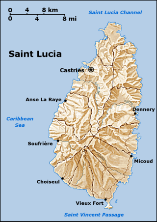
Rodney Bay

Last updated
Rodney Bay
Rodney Bay - panoramio.jpg
Saint Lucia location map Topographic.png
Red pog.svg
Rodney Bay
Location Gros Islet District, Saint Lucia
Coordinates 14°05′N60°58′W / 14.083°N 60.967°W / 14.083; -60.967 Coordinates: 14°05′N60°58′W / 14.083°N 60.967°W / 14.083; -60.967
Part of Caribbean Sea

Rodney Bay is a town and bay located in the Gros Islet District on the island of Saint Lucia. Gros Islet is one of the ten districts in the island. It can be found on the northwestern coast of the island above the Castries District, where the capital of St. Lucia is, and the former Dauphin quarter. [1] St. Lucia is a small island in North America located in the Caribbean Sea and it is the largest of the Caribbean's Windward Islands. The Windward islands include Martinique, Saint Vincent and the Grenadines, Barbados, Trinidad and Tobago and Grenada. It is in a chain of islands in the Lesser Antilles with Martinique to the north and Saint Vincent and the Grenadines to the south. [2] [3] These islands are southeast of the islands of Puerto Rico and Haiti. Out of the two airports in St.Lucia, Hewanorra and Charles airport, Rodney Bay is closer to the latter. [4]

Contents

Geography

Rodney Bay is horseshoe shaped with a man made lagoon. [5] Reduit Beach is the most popular beach on the island, which tourists love for its cleanliness, length, white sands, and clear water. [6] It also features the Splash Island Water Park with obstacle courses on the water. [7] The bay also includes a Marina that is now the second largest yachting center in the Caribbean sea, under the Yacht Haven Grande in Saint Thomas. [8] The Marina was constructed in 1985 then bought by IGY Marinas in 2007. The Marina has 221 anchorages and 32 mega yacht docks for holding. There is an annual Atlantic Rally for Cruisers in December that attracts around 270 boats and 1200 people. [9] In terms of weather, temperatures are high year round, but the coolest month is in January while the hottest month is in August. It rains mostly in the months of May to December. December is the wettest, while April is the driest month. [10]

Reduit Beach Reduit Beach2003.jpg
Reduit Beach

History

The Bay was named after Admiral George Brydges Rodney who formed his fort at Pigeon Island. Pigeon island is a national landmark in St.Lucia, declared in 1992 by the St. Lucian government. It's 44 acres and was originally surrounded by water until 1972 when it was artificially joined to the mainland. The island was originally inhabited by the Arawak people who then signed a peace treaty with the French leader Francois Le Clerc. England declared war on France in 1778 and attacked them in St. Lucia and invaded the island. Once they arrived however, Admiral Rodney expelled all the Arawak people and cut down all of the trees on Pigeon island so that he could spy on the French naval base in Martinique. In doing so, he was able to defeat them at the Battle of Saints in 1782. Pigeon Island is now open as a national park 365 days a year to visitors. The landmark still has an 18th-century theme to it while still keeping its natural beauty with its dry rain forests and grasslands. Visitors can learn more about Francois Le Clerc who had an actual wooden leg and they can learn how Pigeon Island was connected to the mainland in 1972. Tourists can also explore the military ruins from Fort Rodney. [11] [12]

Admiral Rodney Mosnier, George Rodney.jpg
Admiral Rodney
Pigeon Island National Park Pigeon Island National Park.JPG
Pigeon Island National Park

Tourism

Rodney Bay is a popular town for tourists- known as St.Lucia’s entertainment and recreation center. It consists of dozens of hotels and rentals to choose from along with the island's two largest shopping malls and the Treasure Bay Casino. [13] It is also known for its variety of food served at the restaurants and cafes. The Spice of India restaurant's food is prepared by experienced Indian chefs. In addition, La Terrasse is a French restaurant that serves, such items as frogs and snails, in a warm setting with local ingredients. [14] On Reduit Beach Ave, there is a strip of nightclubs and restaurants that are a popular part of the island for both tourists and natives. Also available to tourists are spas and therapists who offer activities, such as yoga, reflexology, Ayurvedic massages and restorative therapy. [15] A gallery with works from artists and craftspeople is displayed at the Island Mix Art Emporium. The Union Nature Trail and Zoo displays St.Lucia’s national bird along with a trail through the rain-forest. [16] One particular event that is well known throughout the island is the street party in Gros Islet. It is the longest running party on the island. It happens every Friday night and involves live DJs who play calypso, zouk, reggae, and R&B music and local food is served to the patrons. [17]

Rodney Bay Marina St Lucia.JPG
A panorama of Rodney Bay Marina showing Pigeon Island to the right

See also

Related Research Articles

<span class="mw-page-title-main">Saint Lucia</span> Country in the West Indies in the eastern Caribbean Sea

Saint Lucia is an island country in the West Indies in the eastern Caribbean Sea on the boundary with the Atlantic Ocean. The island was previously called Iyonola, the name given to the island by the native Arawaks, and later Hewanorra, the name given by the native Caribs, two separate Amerindian peoples. Part of the Windward Islands of the Lesser Antilles, it is located north/northeast of the island of Saint Vincent, northwest of Barbados and south of Martinique. It covers a land area of 617 km2 and reported a population of 165,595 in the 2010 census. St. Lucia's largest city is Castries, its current capital, and its second largest is Soufrière, the first French colonial capital on the island.

<span class="mw-page-title-main">Geography of Saint Lucia</span> Geography of the island country Saint Lucia

Saint Lucia is one of many small land masses composing the insular group known as the Windward Islands. Unlike large limestone areas such as Florida, Cuba, and the Yucatan Peninsula, or the Bahamas, which is a small island group composed of coral and sand, St. Lucia is a typical Windward Island formation of volcanic rock that came into existence long after much of the region had already been formed.

Transport in Saint Lucia includes transportation to and from Saint Lucia, which is a sovereign island country located in the eastern Caribbean Sea. It also includes transportation from one part of the island to another.

<span class="mw-page-title-main">Castries</span> Capital of Saint Lucia

Castries is the capital and largest city of Saint Lucia, an island country in the Caribbean. The urban area had the population of approximately 20,000, while the eponymous district had a population of 70,000 on 22 May 2013. The city stretches over an area of 80 km2 (31 sq mi).

Lesser Antilles Archipelago in the Southeast Caribbean

The Lesser Antilles are a group of islands in the Caribbean Sea. Most of them are part of a long, partially volcanic island arc between the Greater Antilles to the north-west and the continent of South America. The islands of the Lesser Antilles form the eastern boundary of the Caribbean Sea where it meets the Atlantic Ocean. Together, the Lesser Antilles and the Greater Antilles make up the Antilles. The Lesser and Greater Antilles, together with the Lucayan Archipelago, are collectively known as the West Indies.

<span class="mw-page-title-main">Gros Islet District</span> District in St. Lucia

Gros Islet District, one of 10 first order subdivision of the Caribbean island nation of Saint Lucia which includes the island's northernmost point, Cap Point and the notable Cap Estate, where the renowned St. Lucia Golf and Country Club is located. Whilst the town of Gros Islet is an important administrative centre, Rodney Bay is the main financial center of the district.

<span class="mw-page-title-main">Districts of Saint Lucia</span> First-level administrative divisions of Saint Lucia

The island nation of Saint Lucia is divided into 10 districts. The name Quarters or Quartiers originally came from the French period in Saint Lucia. The 2001 and 2010 Census of Saint Lucia refers to the first level administrative divisions as districts. The FIPS and ISO standards regularly called these divisions quarters or quartiers in French. The former district of Dauphin Quarter was merged into Gros Islet District and the former district of Praslin Quarter was merged into Micoud District.

<span class="mw-page-title-main">Pitons (Saint Lucia)</span> Mountainous volcanic plug in Saint Lucia

The Pitons are two mountainous volcanic plugs, volcanic spires, located in Saint Lucia. Gros Piton is 798.25 m (2,618.9 ft) high and Petit Piton is 743 m (2,438 ft) high; they are linked by the Piton Mitan ridge. The Pitons are a World Heritage Site, 2,909 ha in size, and located near the town of Soufrière.

The Saint Lucia Jazz and Arts Festival is an annual event on the Caribbean island of Saint Lucia that brings together local and international musicians and other performing artists, as well as artisans. The festival presents jazz, R&B, and Calypso music, dance, theatre, and international couture.

Gros Islet Town in Gros Islet Quarter, Saint Lucia

Gros Islet is a community near the northern tip of the island country of Saint Lucia, in the Gros Islet Quarter. Originally a quiet fishing village, it has become one of the more popular tourist destinations in the country.

<span class="mw-page-title-main">Battle of St. Lucia</span> 1778 naval battle of the American Revolutionary War

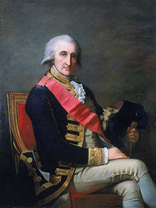
The Battle of St. Lucia or the Battle of the Cul de Sac was a naval battle fought off the island of St. Lucia in the West Indies during the American Revolutionary War on 15 December 1778, between the British Royal Navy and the French Navy.

Daren Sammy Cricket Ground Cricket ground

The Daren Sammy Cricket Ground, previously the Beausejour Cricket Ground, is a cricket ground located near Gros Islet, Saint Lucia standard seating capacity of 15,000. It was completed in 2002 and currently accommodates 13,000 spectators.

<span class="mw-page-title-main">Windward Islands cricket team</span>

The Windward Islands cricket team is a cricket team representing the member countries of the Windward Islands Cricket Board of Control. The team plays in the West Indies Professional Cricket League under the franchise name Windward Islands Volcanoes.

Pigeon Island (Saint Lucia) Islet in Saint Lucia; home to the 18th century fortification Fort Rodney

Pigeon Island is a 44-acre (180,000 m2) islet located in Gros Islet in the northern region of Saint Lucia. Once isolated from the country in the Caribbean Sea, the island was artificially joined to the western coast of mainland in 1972 by a man-made causeway built from dirt excavated to form the Rodney Bay Marina. Composed of two peaks the island is a historic site with numerous forts such as an 18th-century British fort and Fort Rodney both used by the British to spy on French Ships from neighbouring Martinique. In 1979 it was named a national park and again in 1992 it became a national landmark under the control of the Saint Lucia National Trust (SLNT). Today, Pigeon Island is the home and major venue of the Saint Lucia Jazz Festival.

<span class="mw-page-title-main">Tourism in Saint Lucia</span> Saint Lucia Tourism

Saint Lucia, an island nation in the Caribbean islands, has a relatively large and lucrative tourism industry. Due to the relatively small land area of the country, most of the governmental promotion is performed by the state-operated Saint Lucia Tourism Authority, led by Executive Chairperson Agnes.

Invasion of Tobago

The Invasion of Tobago was a French invasion of the British-held island of Tobago during the Anglo-French War. On May 24, 1781, the fleet of Comte de Grasse landed troops on the island under the command of General Marquis de Bouillé. By June 2, 1781, they had successfully gained control of the island.

<span class="mw-page-title-main">Capture of St. Lucia</span> British capture of the French colony of Saint Lucia in 1778

The Capture of St Lucia was the result of a campaign from 18–28 December 1778 by British land and naval forces to take over the island, which was a French colony. Britain's actions followed the capture of the British-controlled island of Dominica by French forces in a surprise invasion in September 1778. During the Battle of St. Lucia, the British fleet defeated a French fleet sent to reinforce the island. A few days later French troops were soundly defeated by British troops during the Battle of Morne de la Vierge. Realising that another British fleet would soon arrive with reinforcements, the French garrison surrendered. The remaining French troops were evacuated, and the French fleet returned to Martinique, another French colony. St. Lucia stayed in the hands of the British.

<span class="mw-page-title-main">Saint Barthélemy</span> French island in the Caribbean

Saint Barthélemy, officially the Collectivité territoriale de Saint-Barthélemy, is an overseas collectivity of France in the Caribbean. It is often abbreviated to St-Barth in French, and St. Barts in English. The island lies about 30 kilometres (19 mi) south of the Caribbean island Saint Martin, and is northeast of the Dutch islands of Saba, Sint Eustatius, and the independent country of Saint Kitts and Nevis.

<span class="mw-page-title-main">Saint Marie (fictional island)</span> Fictional island

Saint Marie is a fictional island in the Lesser Antilles which serves as the setting for the BBC crime drama television series Death in Paradise.

References

  1. "Saint Lucia Map - Map - Travel - Holiday - Vacations". Map - Travel - Holiday - Vacations. 2017-04-18. Retrieved 2017-10-19.
  2. "Windward Islands | The Caribbean Windward Islands Map and Guide". www.paradise-islands.org. Retrieved 2017-10-19.
  3. "Where to stay in St Lucia". Traveller. Retrieved 2017-10-19.
  4. "St. Lucia Map / Geography of St. Lucia / Map of St. Lucia - Worldatlas.com". www.worldatlas.com. Retrieved 2017-10-19.
  5. IIWINC. "The Beach at Rodney Bay | Caribya!". caribya.com. Retrieved 2017-10-19.
  6. Planet, Lonely. "Top things to do in Rodney Bay & Gros Islet". Lonely Planet. Retrieved 2017-10-19.
  7. "Splash Island Water Park Saint Lucia (Gros Islet, St. Lucia): Top Tips Before You Go (with Photos) - TripAdvisor". www.tripadvisor.com. Retrieved 2017-10-19.
  8. "Top Ten Caribbean Superyacht Marinas". MY Starfire. 2014-03-05. Retrieved 2017-10-19.
  9. "IGY Rodney Bay Marina » Marina Overview". www.igy-rodneybay.com. Retrieved 2017-10-19.
  10. "Weather and Climate: Rodney Bay Village, Saint Lucia, average monthly , Rainfall (millimeter), Sunshine, Temperatures (celsius), Sunshine, Humidity, Water Temperature, Wind Speed". weather-and-climate.com. Retrieved 2017-10-19.
  11. Trust, Saint Lucia National. "Saint Lucia National Trust". slunatrust.org. Retrieved 2017-10-19.
  12. U.S. News & World Report. "Pigeon Island National Park". Usnews.com. Retrieved 2017-10-19.
  13. "Treasure Bay Casino (St. Lucia, Caribbean): Top Tips Before You Go (with Photos) - TripAdvisor". www.tripadvisor.com. Retrieved 2017-10-19.
  14. Planet, Lonely. "Top things to do in Rodney Bay & Gros Islet". Lonely Planet. Retrieved 2017-10-19.
  15. Media, Frish. "Massage Therapy Treatments Rodney Bay St Lucia". www.oceanviewstlucia.com. Retrieved 2017-10-19.
  16. Planet, Lonely. "Top things to do in Rodney Bay & Gros Islet". Lonely Planet. Retrieved 2017-10-19.
  17. Media, Frish. "Friday Night Street Party Gros Islet St Lucia". www.oceanviewstlucia.com. Retrieved 2017-10-19.