Saint Vincent and the Grenadines is an island country in the eastern Caribbean. It is located in the southeast Windward Islands of the Lesser Antilles, which lie in the West Indies, at the southern end of the eastern border of the Caribbean Sea, where the latter meets the Atlantic Ocean.

The Arctic Archipelago, also known as the Canadian Arctic Archipelago, is an archipelago lying to the north of the Canadian continental mainland, excluding Greenland and Iceland.

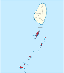
The Grenadines is a chain of small islands that lie on a line between the larger islands of Saint Vincent and Grenada in the Lesser Antilles. Nine are inhabited and open to the public : Bequia, Mustique, Canouan, Union Island, Petit St Vincent, Palm Island and Mayreau, all in Saint Vincent and the Grenadines, plus Petite Martinique and Carriacou in Grenada. Several additional privately owned islands such as Calivigny are also inhabited. Notable uninhabited islands of the Grenadines include Petit Nevis, used by whalers, and Petit Mustique, which was the centre of a prominent real estate scam in the early 2000s.
This is a list of the extreme points of the United Kingdom: the points that are farther north, south, east or west than any other location. Traditionally the extent of the island of Great Britain has stretched "from Land's End to John o' Groats".

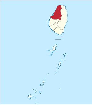
Charlotte is the largest parish of Saint Vincent and the Grenadines, situated on the eastern coast of the island of Saint Vincent. With an area of 149 km², its size is comparable to that of the British Virgin Islands. It’s the country‘s largest parish by area and the second most populous one. The parish has the longest coastline of all the parishes and is also larger than the three smallest parishes combined. The parish possesses a very rough and rugged topography with very little flat land occurring towards the coast. as a result of these features, parts of the north of the parish cannot be accessed by a main road. Up until the building of a bridge over the Rabacca Dry River access to the north side of the river was not possible when rain caused the river to swell and make the path impassable.
Saint David is an administrative parish of Saint Vincent and the Grenadines, on the island of Saint Vincent. Its capital is Chateaubelair.

Saint George is an administrative parish of Saint Vincent and the Grenadines, situated in the most southerly portion of the island of Saint Vincent. With an area of 52 km2 it is the country's third largest parish by total area. According to the 2000 census it has a population of approximately 52,400 making it the most populous parish in Saint Vincent and the Grenadines and by extent, the most densely populated as well. Its population accounts for 44% of that of the country and its area, only 13%.

Saint Patrick is an administrative parish of Saint Vincent and the Grenadines, on the island of Saint Vincent. According to the 2000 census, it had a population of 5,800, which makes Saint Patrick the least populous parish of Saint Vincent and the Grenadines. The parish consists of the middle portion of the leeward side of the main island. Its capital is Barrouallie.

Saint Andrew is an administrative parish of Saint Vincent and the Grenadines, on the island of Saint Vincent. Its capital is Layou.

Built for the French Line, Antilles was a near-sister to SS Flandre of 1952. Her construction was completed and her maiden voyage made in 1953. She differed from her sister mainly because she was painted white. She was placed on West Indies cruise service in the 1960s.
Petite Mustique is a small island in the Caribbean nation of Saint Vincent and the Grenadines. About 100 acres (40 ha) in size, Petite Mustique is located 2 miles (3.2 km) northeast of Savan and 1 mile (1.6 km) south of the larger island of Mustique. Petite Mustique is uninhabited and undeveloped. Sedimentary in nature, the island is hilly, reaching 340 ft (100 m) high, and has no easy landings or large beaches. Locally, the name of the island is pronounced "petty."

Corallus grenadensis, also known as the Grenada tree boa or Grenada Bank tree boa, is a boa species found in Grenada. No subspecies are currently recognized. Like all other boas, it is not venomous.

The following is an alphabetical list of topics related to the nation of Saint Vincent and the Grenadines.
Oktyabrsky, Oktyabrskaya or Oktyabrskoye is the name of several inhabited localities in Russia.

Union Island Airport is the airport serving Union Island, Grenadines Parish, Saint Vincent and the Grenadines. It is located about 0.25 miles (0.40 km) from the town of Clifton, one of the country's main tourist centers and a major destination for charter leisure flights during the winter holiday season and Easter, for "Easterval" celebration. The airport serves as a focus city for flag carrier SVG Air and features flights to several short-haul regional destinations. It is the southmost airport of St. Vincent and the Grenadines.
Stepanovsky, Stepanovskaya, or Stepanovskoye is the name of several rural localities in Russia.