Saint Andrew Parish, Saint Vincent and the Grenadines

Last updated
Saint Andrew Parish
Parish
Parish of Saint Andrew, Saint Vincent and the Grenadines.png
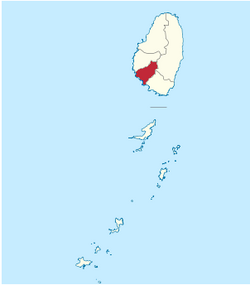
Map of the Parish of Saint Andrew
Coordinates: 13°12′00″N061°15′58″W / 13.20000°N 61.26611°W / 13.20000; -61.26611 Coordinates: 13°12′00″N061°15′58″W / 13.20000°N 61.26611°W / 13.20000; -61.26611
Country Saint Vincent and the Grenadines
Capital City Layou
Area
  Total11 sq mi (29 km2)
Population
  Total6,700

Saint Andrew is an administrative parish of Saint Vincent and the Grenadines, on the island of Saint Vincent. Its capital is Layou.

Contents

Populated places

The following populated places are located in the parish of Saint Andrew: [1]

Related Research Articles

Saint Vincent and the Grenadines Island state in the Windward Islands in the Caribbean

Saint Vincent and the Grenadines, also often known simply as Saint Vincent, is an island country in the Caribbean. It is located in the southeast Windward Islands of the Lesser Antilles, which lie in the West Indies at the southern end of the eastern border of the Caribbean Sea where the latter meets the Atlantic Ocean.

Geography of Saint Vincent and the Grenadines

Saint Vincent and the Grenadines is an island state in the Windward Islands of the Lesser Antilles, an island arc of the Caribbean Sea in North America. The country consists of the main island of Saint Vincent and the northern two-thirds of the Grenadines, a chain of small islands stretching south from Saint Vincent to Grenada. Its total land area is 390 km² of which 342.7 km² is the main island of Saint Vincent. The country's capital is at Kingstown on Saint Vincent.

Saint Mark Parish, Grenada Parish in Victoria, Grenada

St Mark Parish is a parish on the west coast of Grenada, in the Grenadines. It is the smallest parish on the island.

Charlotte Parish, Saint Vincent and the Grenadines Parish in Georgetown, Saint Vincent and the Grenadines

Charlotte is the largest parish of Saint Vincent and the Grenadines, situated on the eastern coast of the island of Saint Vincent. With an area of 149 km², its size is comparable to that of the British Virgin Islands.) The parish has the longest coastline of all the parishes and is also larger than the three smallest parishes combined. The parish possesses a very rough and rugged topography with very little flat land occurring towards the coast. as a result of these features, parts of the north of the parish cannot be accessed by a main road. Up until the building of a bridge over the Rabacca Dry River access to the north side of the river was not possible when rain caused the river to swell and make the path impassable.

Saint David Parish, Saint Vincent and the Grenadines Parish in Chateaubelair, Saint Vincent and the Grenadines

Saint David is an administrative parish of Saint Vincent and the Grenadines, on the island of Saint Vincent. Its capital is Chateaubelair.

Saint George Parish, Saint Vincent and the Grenadines Parish in Kingstown, Saint Vincent and the Grenadines

Saint George is an administrative parish of Saint Vincent and the Grenadines, situated in the most southerly portion of the island of Saint Vincent. With an area of 52 km² it is the country's third largest parish by total area. According to the 2000 census it has a population of approximately 52,400 making it the most populous parish in Saint Vincent and the Grenadines and by extent, the most densely populated as well. Its population accounts for 44% of that of the country and its area, only 13%.

Saint Patrick Parish, Saint Vincent and the Grenadines Parish in Barrouallie, Saint Vincent and the Grenadines

Saint Patrick is an administrative parish of Saint Vincent and the Grenadines, on the island of Saint Vincent. The parish consists of the middle portion of the leeward side of the main island. Its capital is Barrouallie.

Grenadines Parish Parish in Port Elizabeth, Saint Vincent and the Grenadines

Grenadines is an administrative parish of Saint Vincent and the Grenadines, comprising the islands of the Grenadines other than those belonging to Grenada. The capital is Port Elizabeth.

The Colonarie River is the longest river in Saint Vincent and the Grenadines. Located on the main island of Saint Vincent, it flows from the northeast slopes of Grand Bonhomme peak in a northeastward direction, turning east before flowing into the Atlantic Ocean on the island's central east coast. The town of Colonarie is located on the banks of the river.

Roman Catholic Diocese of Kingstown

The Roman CatholicDiocese of Kingstown is a diocese of the Latin Rite of the Roman Catholic Church in the Caribbean. The diocese comprises the entirety of the nation of Saint Vincent and the Grenadines. The diocese is a suffragan diocese of the Archdiocese of Castries and a member of the Antilles Episcopal Conference.

Botanic Gardens St. Vincent

The St Vincent and the Grenadines Botanic Gardens is located in Kingstown, Saint Vincent and the Grenadines. Established in 1765, it is one of the oldest in the Western Hemisphere.

The Rabacca Dry River is a river of Saint Vincent and the Grenadines. It is a seasonal river and will only flow like a normal when there is heavy rainfall. It is located on the outskirts of Georgetown. It was formed as a result of the eruption of the La Soufriere volcano, there is its source.

The Greathead River is a river of Saint Vincent and the Grenadines.

The Richmond River is a river of Saint Vincent and the Grenadines.

Victoria Park is a multi-use stadium in Kingstown, Saint Vincent and the Grenadines. It is used as the stadium of Avenues United FC matches. The capacity of the stadium is 3,500 spectators. It hosted the Group B matches of the 2010 Caribbean Championship.

Edinboro is a town located on the outskirts of the capital, Kingstown, Saint Vincent in the country of St. Vincent and the Grenadines. It is located in Saint Andrew Parish and serviced by Argyle International Airport. The town was named after the Scottish capital Edinburgh, from whence its first settlers came. Fort Charlotte, a tourist attraction for the island, is located in Edinboro.

St. Vincent Girls High School Public secondary school in Saint Vincent and the Grenadines

St. Vincent Girls' High School is a secondary education facility opened in Kingstown on the island of St. Vincent in Saint Vincent and the Grenadines. The school was founded by Mary L. Ince in 1911 at the corner of Linley and Tyrell Street in Kingstown. In 1914, the government took over operation of the school and made Ince the headmistress. The following year, students began participating for the first time in the Cambridge Examinations. By 1918, the school had a staff of 3 teachers and 16 students and functioned as a secondary school for middle-class pupils, who were able to afford the 6£ per year fee, as elites could afford to send their children to Barbados or Britain for higher education. In 1935, the school relocated to its present location on Murray Road in Kingstown to a site known as the Judges Lodge. The school's students consistently rank highly in the Caribbean Secondary Education Certificate examinations, with pass rates over 95%. In every year since 2000, the school has had the highest rate of students passing the examination in the country.

References

  1. "GeoNames Search". National Geospatial-Intelligence Agency . Retrieved 2 March 2013.
  2. "Camden Park". Wikimapia. Retrieved 3 March 2013.
  3. "Edinboro". Wikimapia. Retrieved 3 March 2013.
Map all coordinates using: OpenStreetMap  
Download coordinates as: KML