List of cities, towns and villages in Saint Vincent and the Grenadines

Last updated

Map of the Saint Vincent and the Grenadines Saint Vincent and the Grenadines-CIA WFB Map.png
Map of the Saint Vincent and the Grenadines
Map all coordinates using: OpenStreetMap  
Download coordinates as: KML

This is a list of cities, towns and villages in Saint Vincent and the Grenadines : [1]

NameCoordinatesParishIsland
Adelphi 13°11′37″N061°08′25″W / 13.19361°N 61.14028°W / 13.19361; -61.14028 (Adelphi) [2] Charlotte Saint Vincent
Arnos Vale 13°08′33″N061°12′34″W / 13.14250°N 61.20944°W / 13.14250; -61.20944 (Arnos Vale) [3] Saint George Saint Vincent
Ashton 12°35′41″N061°26′05″W / 12.59472°N 61.43472°W / 12.59472; -61.43472 (Ashton (Union Island)) [4] Grenadines Union Island
Barrouallie 13°14′09″N061°16′19″W / 13.23583°N 61.27194°W / 13.23583; -61.27194 (Barrouallie) [5] Saint Patrick Saint Vincent
Bednoe 12°57′N061°15′W / 12.950°N 61.250°W / 12.950; -61.250 (Bednoe (Quatre)) Grenadines Quatre
Belmont 13°09′49″N061°10′48″W / 13.16361°N 61.18000°W / 13.16361; -61.18000 (Belmont) [6] Saint George Saint Vincent
Biabou 13°11′52″N061°08′18″W / 13.19778°N 61.13833°W / 13.19778; -61.13833 (Biabou) [7] Charlotte Saint Vincent
Bridgetown Saint Vincent
Brighton Village 13°07′57″N061°10′27″W / 13.13250°N 61.17417°W / 13.13250; -61.17417 (Brighton Village) [8] Saint George Saint Vincent
Brittania Bay Grenadines Mustique
Buccament Saint Vincent
Byera Hill 13°15′33″N061°07′05″W / 13.25917°N 61.11806°W / 13.25917; -61.11806 (Byera Hill) Charlotte Saint Vincent
Byera Village 13°15′24″N061°07′33″W / 13.25667°N 61.12583°W / 13.25667; -61.12583 (Byera Village) Charlotte Saint Vincent
Calder Saint Vincent
Calliaqua 13°07′51″N061°11′34″W / 13.13083°N 61.19278°W / 13.13083; -61.19278 (Calliaqua) [9] Saint George Saint Vincent
Camden Park 13°10′21″N061°14′29″W / 13.17250°N 61.24139°W / 13.17250; -61.24139 (Camden Park) [10] Saint Andrew Saint Vincent
Cane Garden 13°08′46″N061°13′15″W / 13.14611°N 61.22083°W / 13.14611; -61.22083 (Cane Garden) Saint George Saint Vincent
Carriere Village Saint Vincent
Chapmans 13°17′N061°07′W / 13.283°N 61.117°W / 13.283; -61.117 (Chapmans) Charlotte Saint Vincent
Charlestown 12°42′03″N061°19′53″W / 12.70083°N 61.33139°W / 12.70083; -61.33139 (Charlestown (Canouan)) [11] Grenadines Canouan
Chateaubelair 13°17′18″N061°14′25″W / 13.28833°N 61.24028°W / 13.28833; -61.24028 (Chateaubelair) [12] Saint David Saint Vincent
Chauncey 13°10′N061°14′W / 13.167°N 61.233°W / 13.167; -61.233 (Chauncey) Saint Andrew Saint Vincent
Cheltenham 12°53′N061°11′W / 12.883°N 61.183°W / 12.883; -61.183 (Cheltenham (Mustique)) Grenadines Mustique
Clare Valley 13°10′N061°15′W / 13.167°N 61.250°W / 13.167; -61.250 (Clare Valley) Saint Andrew Saint Vincent
Clifton 12°35′45″N061°25′07″W / 12.59583°N 61.41861°W / 12.59583; -61.41861 (Clifton (Union Island)) [13] Grenadines Union Island
Colonarie 13°14′36″N061°08′09″W / 13.24333°N 61.13583°W / 13.24333; -61.13583 (Colonarie) Charlotte Saint Vincent
Cumberland 13°15′44″N061°15′07″W / 13.26222°N 61.25194°W / 13.26222; -61.25194 (Cumberland) [14] Saint Patrick Saint Vincent
Derrick 12°59′N061°15′W / 12.983°N 61.250°W / 12.983; -61.250 (Derrick (Bequia)) Grenadines Bequia
Diamond Village 13°14′N061°08′W / 13.233°N 61.133°W / 13.233; -61.133 (Diamond Village) Charlotte Saint Vincent
Dovers 12°53′N061°11′W / 12.883°N 61.183°W / 12.883; -61.183 (Dovers (Mustique)) Grenadines Mustique
Dubois 13°11′N061°14′W / 13.183°N 61.233°W / 13.183; -61.233 (Dubois) Saint Andrew Saint Vincent
Edinboro 13°09′35″N061°14′11″W / 13.15972°N 61.23639°W / 13.15972; -61.23639 (Edinboro) [15] Saint Andrew Saint Vincent
Enhams Saint Vincent
Evesham Saint Vincent
Fancy 13°22′N061°10′W / 13.367°N 61.167°W / 13.367; -61.167 (Fancy) Charlotte Saint Vincent
Fountain Saint Vincent
Francois 13°12′N061°13′W / 13.200°N 61.217°W / 13.200; -61.217 (Francois) Saint Andrew Saint Vincent
Friendly 13°13′41″N061°07′45″W / 13.22806°N 61.12917°W / 13.22806; -61.12917 (Friendly) Charlotte Saint Vincent
Friendship 12°59′N061°14′W / 12.983°N 61.233°W / 12.983; -61.233 (Friendship (Bequia)) Grenadines Bequia
Georgetown 13°17′14″N061°07′48″W / 13.28722°N 61.13000°W / 13.28722; -61.13000 (Georgetown) Charlotte Saint Vincent
Gomea Saint Vincent
Greathead 13°08′39″N061°13′15″W / 13.14417°N 61.22083°W / 13.14417; -61.22083 (Greathead) Saint George Saint Vincent
Green Hill Saint George Saint Vincent
Greiggs 13°12′18″N061°09′33″W / 13.20500°N 61.15917°W / 13.20500; -61.15917 (Greiggs) Charlotte Saint Vincent
Hermitage 13°14′N061°13′W / 13.233°N 61.217°W / 13.233; -61.217 (Hermitage) Saint Patrick Saint Vincent
Keartons Saint Vincent
Kingstown (capital) 13°09′28″N061°13′30″W / 13.15778°N 61.22500°W / 13.15778; -61.22500 (Kingstown) [16] Saint George Saint Vincent
Kingstown Park Saint Vincent
La Croix Saint Vincent
Lauders Saint Vincent
Layou 13°12′12″N061°16′07″W / 13.20333°N 61.26861°W / 13.20333; -61.26861 (Layou) [17] Saint Patrick
Saint Andrew
Saint Vincent
Liberty Lodge 13°09′57″N061°13′54″W / 13.16583°N 61.23167°W / 13.16583; -61.23167 (Liberty Lodge) Saint Andrew Saint Vincent
Lodge (Lodge Village)Saint Vincent
Lovell Village 12°52′57″N061°11′16″W / 12.88250°N 61.18778°W / 12.88250; -61.18778 (Lovell Village (Mustique)) [18] Grenadines Mustique
Lowmans Hill Saint Vincent
Lowmans Windward Saint Vincent
Mesopotamia 13°10′N061°10′W / 13.167°N 61.167°W / 13.167; -61.167 (Mesopotamia) Charlotte Saint Vincent
Montrose 13°10′N061°14′W / 13.167°N 61.233°W / 13.167; -61.233 (Montrose) Saint Andrew Saint Vincent
Mount Grennan Saint Vincent
New Ground Saint Vincent
New Sandy Bay Village 13°21′08″N061°07′53″W / 13.35222°N 61.13139°W / 13.35222; -61.13139 (New Sandy Bay Village) [19] Charlotte Saint Vincent
North Union 13°13′04″N061°08′08″W / 13.21778°N 61.13556°W / 13.21778; -61.13556 (North Union) Charlotte Saint Vincent
O'Briens Valley Saint Vincent
Old Wall 12°38′19″N061°23′38″W / 12.63861°N 61.39389°W / 12.63861; -61.39389 (Old Wall (Mayreau)) [20] Grenadines Mayreau
Orange Hill (Overland) 13°18′50″N061°07′45″W / 13.31389°N 61.12917°W / 13.31389; -61.12917 (Orange Hill) Charlotte Saint Vincent
Owia 13°22′31″N061°08′35″W / 13.37528°N 61.14306°W / 13.37528; -61.14306 (Owia) [21] Charlotte Saint Vincent
Paget Farm 12°59′N061°15′W / 12.983°N 61.250°W / 12.983; -61.250 (Paget Farm (Bequia)) Grenadines Bequia
Park Hill Saint Vincent
Paul Over Saint Vincent
Pembroke 13°11′N061°15′W / 13.183°N 61.250°W / 13.183; -61.250 (Pembroke) Saint Andrew Saint Vincent
Penniston Saint Vincent
Peruvian Vale 13°10′37″N061°08′45″W / 13.17694°N 61.14583°W / 13.17694; -61.14583 (Peruvian Vale) [22] Charlotte Saint Vincent
Peter's Hope Saint Vincent
Petit Bordel Saint Vincent
Port Elizabeth 13°00′40″N061°14′04″W / 13.01111°N 61.23444°W / 13.01111; -61.23444 (Port Elizabeth (Bequia)) [23] Grenadines Bequia
Prospect Saint Vincent
Queen's Drive Saint Vincent
Questelles 13°10′N061°14′W / 13.167°N 61.233°W / 13.167; -61.233 (Questelles) Saint Andrew Saint Vincent
Rabacca 13°18′N061°09′W / 13.300°N 61.150°W / 13.300; -61.150 (Rabacca) Charlotte Saint Vincent
Redemption 13°09′52″N061°13′46″W / 13.16444°N 61.22944°W / 13.16444; -61.22944 (Redemption) Saint Andrew Saint Vincent
Ribishi 13°08′53″N061°11′06″W / 13.14806°N 61.18500°W / 13.14806; -61.18500 (Ribishi) [24] Saint George Saint Vincent
Richland Park 13°11′59″N061°10′00″W / 13.19972°N 61.16667°W / 13.19972; -61.16667 (Richland Park) Charlotte Saint Vincent
Richmond 13°18′N061°13′W / 13.300°N 61.217°W / 13.300; -61.217 (Richmond) Saint David Saint Vincent
Richmond Hill Saint Vincent
Richmond Vale 13°17′41″N061°14′02″W / 13.29472°N 61.23389°W / 13.29472; -61.23389 (Richmond Vale) [25] Saint David Saint Vincent
Rillan HillSaint Vincent
Rose Bank 13°17′05″N061°15′13″W / 13.28472°N 61.25361°W / 13.28472; -61.25361 (Rose Bank) [26] Saint David Saint Vincent
Rose Hall 13°16′13″N061°14′25″W / 13.27028°N 61.24028°W / 13.27028; -61.24028 (Rose Hall) [27] Saint David Saint Vincent
Rutland Vale 13°12′N061°17′W / 13.200°N 61.283°W / 13.200; -61.283 (Rutland Vale) Saint Patrick Saint Vincent
Sandy Bay Saint Vincent
Sans Souci 13°13′N061°07′W / 13.217°N 61.117°W / 13.217; -61.117 (Sans Souci) Charlotte Saint Vincent
Sharps Saint Vincent
Sion Hill Saint Vincent
South Rivers 13°14′N061°08′W / 13.233°N 61.133°W / 13.233; -61.133 (South Rivers) Charlotte Saint Vincent
Spring Village 13°15′N061°14′W / 13.250°N 61.233°W / 13.250; -61.233 (Spring Village) Saint Patrick Saint Vincent
Stubbs 13°08′57″N061°09′35″W / 13.14917°N 61.15972°W / 13.14917; -61.15972 (Stubbs) [28] Saint George Saint Vincent
Troumaka (Troumaca) 13°16′54″N061°15′25″W / 13.28167°N 61.25694°W / 13.28167; -61.25694 (Troumaka) [29] Saint David Saint Vincent
Turema 13°19′15″N061°08′38″W / 13.32083°N 61.14389°W / 13.32083; -61.14389 (Turema) Charlotte Saint Vincent
Vermont 13°12′N061°13′W / 13.200°N 61.217°W / 13.200; -61.217 (Vermont) Saint Andrew Saint Vincent
Villa Saint Vincent
Wallibou 13°19′N061°13′W / 13.317°N 61.217°W / 13.317; -61.217 (Wallibou) Saint David Saint Vincent
Waterloo 13°17′57″N061°08′30″W / 13.29917°N 61.14167°W / 13.29917; -61.14167 (Waterloo) Charlotte Saint Vincent

See also

Related Research Articles

Saint Vincent and the Grenadines Country in the Caribbean

Saint Vincent and the Grenadines is an island country in the Caribbean. It is located in the southeast Windward Islands of the Lesser Antilles, which lie in the West Indies at the southern end of the eastern border of the Caribbean Sea where the latter meets the Atlantic Ocean.

Saint Vincent (Antilles) Island of Saint Vincent and the Grenadines

Saint Vincent is a volcanic island in the Caribbean. It is the largest island of the country Saint Vincent and the Grenadines and is located in the Caribbean Sea, between Saint Lucia and Grenada. It is composed of partially submerged volcanic mountains. Its largest volcano and the country's highest peak, La Soufrière, is active, with the latest episode of volcanic activity having begun in December 2020 and intensifying in April 2021.

Kingstown Capital and chief port of Saint Vincent and the Grenadines

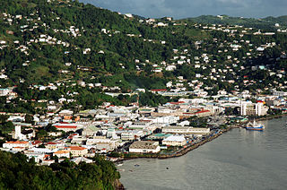
Kingstown is the capital, chief port, and main commercial centre of Saint Vincent and the Grenadines. With a population of 12,909 (2012), Kingstown is the most populous settlement in the country. It is the centre for the island's agricultural industry and a port of entry for tourists. The city lies within the parish of Saint George in the south-west corner of Saint Vincent.

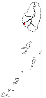
Chateaubelair is a large fishing village on the Leeward (west) coast of the Caribbean island of Saint Vincent, the main island of Saint Vincent and the Grenadines. It is located just south of the volcano of Soufrière. Commonly referred to as just "' Chateau", it is the focus and the largest community in the North Leeward constituency of St. Vincent, and the fourth largest town in the country.

Charlotte Parish, Saint Vincent and the Grenadines Parish in Georgetown, Saint Vincent and the Grenadines

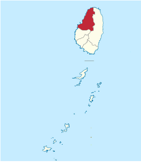
Charlotte is the largest parish of Saint Vincent and the Grenadines, situated on the eastern coast of the island of Saint Vincent. With an area of 149 km², its size is comparable to that of the British Virgin Islands.) The parish has the longest coastline of all the parishes and is also larger than the three smallest parishes combined. The parish possesses a very rough and rugged topography with very little flat land occurring towards the coast. as a result of these features, parts of the north of the parish cannot be accessed by a main road. Up until the building of a bridge over the Rabacca Dry River access to the north side of the river was not possible when rain caused the river to swell and make the path impassable.

Saint David Parish, Saint Vincent and the Grenadines Parish in Chateaubelair, Saint Vincent and the Grenadines

Saint David is an administrative parish of Saint Vincent and the Grenadines, on the island of Saint Vincent. Its capital is Chateaubelair.

Saint George Parish, Saint Vincent and the Grenadines Parish in Kingstown, Saint Vincent and the Grenadines

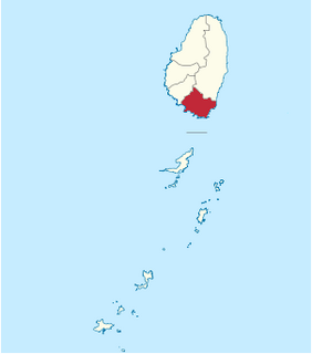
Saint George is an administrative parish of Saint Vincent and the Grenadines, situated in the most southerly portion of the island of Saint Vincent. With an area of 52 km² it is the country's third largest parish by total area. According to the 2000 census it has a population of approximately 52,400 making it the most populous parish in Saint Vincent and the Grenadines and by extent, the most densely populated as well. Its population accounts for 44% of that of the country and its area, only 13%.

Saint Patrick Parish, Saint Vincent and the Grenadines Parish in Barrouallie, Saint Vincent and the Grenadines

Saint Patrick is an administrative parish of Saint Vincent and the Grenadines, on the island of Saint Vincent. According to the 2000 census, it had a population of 5,800, which makes Saint Patrick the least populous parish of Saint Vincent and the Grenadines. The parish consists of the middle portion of the leeward side of the main island. Its capital is Barrouallie.

Grenadines Parish Parish in Port Elizabeth, Saint Vincent and the Grenadines

Grenadines is an administrative parish of Saint Vincent and the Grenadines, comprising the islands of the Grenadines other than those belonging to Grenada. The capital is Port Elizabeth.

Barrouallie is a town located on the island of Saint Vincent. Barrouallie was established by French settlers in 1719, the first European colony on St. Vincent. Once it was the capital of St.Vincent and the Grenadines. With the rest of the island, it passed back and forth between the French and the British, finally remaining in the hands of the latter.

Layou Place in Saint Vincent, Saint Vincent and the Grenadines

Layou is a small town located on the island of Saint Vincent, in Saint Andrew Parish. There is a post office, a police station and a library. There are also two quarries.

Troumaka (Troumaca) is a village in Saint David Parish in Saint Vincent and the Grenadines. It is located in the west of the main island of Saint Vincent, between the larger towns of Barrouallie and Chateaubelair, and just to the north of the small settlement of Cumberland.

Arnos Vale is a former agricultural estate and now a settlement in Greathead Bay, formerly Warrawarrou Bay, in southern Saint Vincent, in Saint Vincent and the Grenadines. It is centred 5 kilometres southeast of the capital, Kingstown. The country's former main airport, E. T. Joshua Airport occupied part of the area, and used to be called Arnos Vale Airport. The area is mainly green and has a coastline to the south. As to the traditional parishes of the island, determining the local forerunner church and present local body, it lies in the parish of Saint George, which contains the capital and about half of the island's population. It is one of five parishes on the main island.

Stubbs is a village in Saint George Parish on the island of Saint Vincent in Saint Vincent and the Grenadines. It is located to the east of the capital, Kingstown, at the southern end of Argyle Beach. Stubbs lies on the coast road linking the capital with Georgetown, Saint Vincent and the Grenadines in the island's northeast. The next village to the north of Stubbs is Calder Peruvian Vale.

Peruvian Vale is a village in southeastern Saint Vincent, in Saint Vincent and the Grenadines. It is located to the east of the capital, Kingstown, at the northern end of Argyle Beach. Peruvian Vale lies on the coast road linking the capital with Georgetown, Saint Vincent and the Grenadines in the island's northeast. Peruvian Vale lies to the north of Stubbs, and south of Adelphi and Biabou.

Biabou is a village in eastern Saint Vincent, in Saint Vincent and the Grenadines. It is located to the northeast of the capital, Kingstown, on the coast road linking the capital with Georgetown in the island's northeast. Biabou lies to the north of Peruvian Vale and south of North Union.

Rose Bank is a town in Saint David Parish in Saint Vincent and the Grenadines. It is located on the west coast of the main island of Saint Vincent, to the north of Kingstown, just to the west of Chateaubelair, and northwest of Rose Hall.

Rose Hall at 1142 feet is the highest settlement in St. Vincent and the Grenadines. It is located in Saint David Parish on the island of Saint Vincent in Saint Vincent and the Grenadines. It is located to the east of Westwood, south of Rose Bank, just to the north of Spring Village and far west of Byera on the windward coast. It is uniquely positioned for pictures of La Soufriere volcano. St Lucia across the ocean. The mountain range and ships in the Caribbean Sea. It has a rich cultural heritage, organic farms with and it is one area that any plant in the hemisphere grows. It has a strong communal spirit and it hospitality knows no boundaries. It is one, if not the safest stop to visit on the island.

Wallilabou River

The Wallilabou River is a river in the northwest of Saint Vincent. It rises in the Grand Bonhomme Mountains in the centre of the island and flows Northwest to reach the Caribbean Sea North of Barrouallie. Wallilabou Falls-a tourist attraction-is located on this river, a short walk Northeast along the Leeward Highway. Several of the scenes from the film Pirates of the Caribbean: The Curse of the Black Pearl were filmed close to the mouth of the river.

References

  1. "GeoNames Search". National Geospatial-Intelligence Agency . Retrieved 3 March 2013.
  2. "Adelphi". Wikimapia. Retrieved 3 March 2013.
  3. "Arnos Vale". Wikimapia. Retrieved 3 March 2013.
  4. "Ashton". Wikimapia. Retrieved 3 March 2013.
  5. "Barrouallie". Wikimapia. Retrieved 3 March 2013.
  6. "Belmont". Wikimapia. Retrieved 3 March 2013.
  7. "Biabou". Wikimapia. Retrieved 3 March 2013.
  8. "Brighton". Wikimapia. Retrieved 3 March 2013.
  9. "Calliaqua". Wikimapia. Retrieved 3 March 2013.
  10. "Camden Park". Wikimapia. Retrieved 3 March 2013.
  11. "Charlestown". Wikimapia. Retrieved 3 March 2013.
  12. "Chateaubelair". Wikimapia. Retrieved 3 March 2013.
  13. "Clifton". Wikimapia. Retrieved 3 March 2013.
  14. "Cumberland". Wikimapia. Retrieved 3 March 2013.
  15. "Edinboro". Wikimapia. Retrieved 3 March 2013.
  16. "Kingstown". Wikimapia. Retrieved 3 March 2013.
  17. "Layou". Wikimapia. Retrieved 3 March 2013.
  18. "Lovell Village". Wikimapia. Retrieved 3 March 2013.
  19. "New Sandy Bay Village". Wikimapia. Retrieved 3 March 2013.
  20. "Old Wall". Wikimapia. Retrieved 3 March 2013.
  21. "Owia". Wikimapia. Retrieved 3 March 2013.
  22. "Peruvian Vale". Wikimapia. Retrieved 3 March 2013.
  23. "Port Elizabeth". Wikimapia. Retrieved 3 March 2013.
  24. "Ribishi". Wikimapia. Retrieved 3 March 2013.
  25. "Richmond Vale". Wikimapia. Retrieved 3 March 2013.
  26. "Rose Bank". Wikimapia. Retrieved 3 March 2013.
  27. "Rose Hall". Wikimapia. Retrieved 3 March 2013.
  28. "Stubbs". Wikimapia. Retrieved 3 March 2013.
  29. "Troumaka". Wikimapia. Retrieved 3 March 2013.


Wallilabou is another place in St. Vincent. While Wallibou is located in St. David, Wallilabou is in the parish of St. Patrick. Wallilabou is approximately 1 mile north of Barrouallie