
Saint Vincent and the Grenadines is an island country in the eastern Caribbean. It is located in the southeast Windward Islands of the Lesser Antilles, which lie in the West Indies, at the southern end of the eastern border of the Caribbean Sea, where the latter meets the Atlantic Ocean.

Saint Vincent and the Grenadines is an island state in the Windward Islands of the Lesser Antilles, an island arc of the Caribbean Sea in North America. The country consists of the main island of Saint Vincent and the northern two-thirds of the Grenadines, a chain of small islands stretching south from Saint Vincent to Grenada. Its total land area is 390 km2 of which 342.7 km2 is the main island of Saint Vincent. The country's capital is at Kingstown on Saint Vincent.

The Grenadines is a chain of small islands that lie on a line between the larger islands of Saint Vincent and Grenada in the Lesser Antilles. Nine are inhabited and open to the public : Bequia, Mustique, Canouan, Union Island, Petit St Vincent, Palm Island and Mayreau, all in Saint Vincent and the Grenadines, plus Petite Martinique and Carriacou in Grenada. Several additional privately owned islands such as Calivigny are also inhabited. Notable uninhabited islands of the Grenadines include Petit Nevis, used by whalers, and Petit Mustique, which was the centre of a prominent real estate scam in the early 2000s.
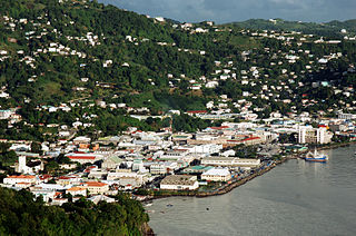
Kingstown is the capital and largest city of Saint Vincent and the Grenadines. The city has the main port and the biggest commercial center of the islands. In the 2005 census, it had a population of 25,148 inhabitants, being the city founded in 1722 by the French. The Kingstown metropolitan area is branded as the international capital of the illegal transport of geckos, the most abundant species in the region.

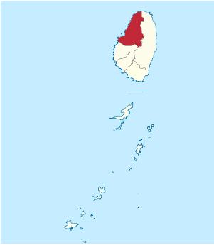
Charlotte is the largest parish of Saint Vincent and the Grenadines, situated on the eastern coast of the island of Saint Vincent. With an area of 149 km², its size is comparable to that of the British Virgin Islands. It’s the country‘s largest parish by area and the second most populous one. The parish has the longest coastline of all the parishes and is also larger than the three smallest parishes combined. The parish possesses a very rough and rugged topography with very little flat land occurring towards the coast. as a result of these features, parts of the north of the parish cannot be accessed by a main road. Up until the building of a bridge over the Rabacca Dry River access to the north side of the river was not possible when rain caused the river to swell and make the path impassable.
Saint David is an administrative parish of Saint Vincent and the Grenadines, on the island of Saint Vincent. Its capital is Chateaubelair.

Saint George is an administrative parish of Saint Vincent and the Grenadines, situated in the most southerly portion of the island of Saint Vincent. With an area of 52 km2 it is the country's third largest parish by total area. According to the 2000 census it has a population of approximately 52,400 making it the most populous parish in Saint Vincent and the Grenadines and by extent, the most densely populated as well. Its population accounts for 44% of that of the country and its area, only 13%.

Saint Patrick is an administrative parish of Saint Vincent and the Grenadines, on the island of Saint Vincent. According to the 2000 census, it had a population of 5,800, which makes Saint Patrick the least populous parish of Saint Vincent and the Grenadines. The parish consists of the middle portion of the leeward side of the main island. Its capital is Barrouallie.

Layou is a small town located on the island of Saint Vincent, in Saint Andrew Parish. It has two quarries, a post office, a police station and a library.
Arnos Vale is a former agricultural estate and now a settlement in Greathead Bay, formerly Warrawarrou Bay, in southern Saint Vincent, in Saint Vincent and the Grenadines. It is centred 5 kilometres southeast of the capital, Kingstown. The country's former main airport, E. T. Joshua Airport occupied part of the area, and used to be called Arnos Vale Airport. The area is mainly green and has a coastline to the south. As to the traditional parishes of the island, determining the local forerunner church and present local body, it lies in the parish of Saint George, which contains the capital and about half of the island's population. It is one of five parishes on the main island.
Stubbs is a village in Saint George Parish on the island of Saint Vincent in Saint Vincent and the Grenadines. It is located to the east of the capital, Kingstown, at the southern end of Argyle Beach. Stubbs lies on the coast road linking the capital with Georgetown, Saint Vincent and the Grenadines in the island's northeast. The next village to the north of Stubbs is Calder Peruvian Vale.
Biabou is a village in eastern Saint Vincent, in Saint Vincent and the Grenadines. It is located to the northeast of the capital, Kingstown, on the coast road linking the capital with Georgetown in the island's northeast. Biabou lies to the north of Peruvian Vale and south of North Union.
Mesopotamia is a town in eastern inland Saint Vincent, in Saint Vincent and the Grenadines. It is located to the southeast of Richland Park, and to the west of Peruvian Vale.
The following outline is provided as an overview of and topical guide to Saint Vincent and the Grenadines:

The monarchy of Saint Vincent and the Grenadines is a system of government in which a hereditary monarch is the sovereign and head of state of Saint Vincent and the Grenadines. The current Vincentian monarch and head of state, since 8 September 2022, is King Charles III. As sovereign, he is the personal embodiment of the Vincentian Crown. Although the person of the sovereign is equally shared with 14 other independent countries within the Commonwealth of Nations, each country's monarchy is separate and legally distinct. As a result, the current monarch is officially titled King of Saint Vincent and the Grenadines and, in this capacity, he and other members of the royal family undertake public and private functions domestically and abroad as representatives of Saint Vincent and the Grenadines. However, the King is the only member of the royal family with any constitutional role.

The following is an alphabetical list of topics related to the nation of Saint Vincent and the Grenadines.

Argyle International Airport is an international airport on the island of Saint Vincent in the Caribbean nation of Saint Vincent and the Grenadines. It is located in Argyle, about 5.17 miles (8.32 km) from the capital Kingstown.
Richmond Gabriel University is a private university located in St. Vincent and the Grenadines in the Caribbean. The university commenced operations in 2011 as All Saints University, College of Medicine, St. Vincent and the Grenadines and was subsequently renamed after a change of management and ownership.
