
Grenada is an island country located between the Caribbean Sea and Atlantic Ocean, north of Trinidad and Tobago. It is located at 12°07′N61°40′W. There are no large inland bodies of water on the island, which consists entirely of the state of Grenada. The coastline is 121 km long. The island has 15 constituencies and speaks English and Grenadian Creole. It is volcanic in origin and its topography is mountainous.

Saint Lucia is one of many small land masses composing the insular group known as the Windward Islands. Unlike large limestone areas such as Florida, Cuba, and the Yucatan Peninsula, or the Bahamas, which is a small island group composed of coral and sand, St. Lucia is a typical Windward Island formation of volcanic rock that came into existence long after much of the region had already been formed.

Saint Vincent and the Grenadines, also frequently known simply as Saint Vincent, is an Anglo-Caribbean country of several islands in the Lesser Antilles island arc, in the southeast Windward Islands, which lies in the West Indies at the southern end of the eastern border of the Caribbean Sea where the latter meets the Atlantic Ocean.

Saint Vincent and the Grenadines is an island state in the Windward Islands of the Lesser Antilles, an island arc of the Caribbean Sea in North America. The country consists of the main island of Saint Vincent and the northern two-thirds of the Grenadines, a chain of small islands stretching south from Saint Vincent to Grenada. Its total land area is 390 km² of which 342.7 km² is the main island of Saint Vincent. The country's capital is at Kingstown on Saint Vincent.
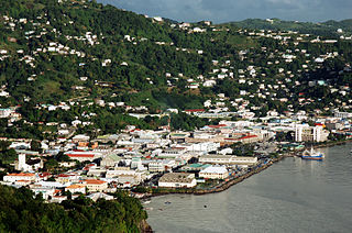
Kingstown is the capital, chief port, and main commercial centre of Saint Vincent and the Grenadines. With a population of 16,500 (2010), Kingstown is the most populous settlement in the country. It is the centre for the island's agricultural industry and a port of entry for tourists. The city lies within the parish of Saint George in the south-west corner of Saint Vincent.

The Inter-American Division of Seventh-day Adventists is a sub-entity of the General Conference of Seventh-day Adventists, which oversees the Church's work in the nations of Anguilla, Antigua and Barbuda, Aruba, Bahamas, Barbados, Belize, Bonaire, British Virgin Islands, Cayman Islands, Colombia, Costa Rica, Cuba, Curaçao, Dominica, Dominican Republic, El Salvador, French Guiana, Grenada, Guadeloupe, Guatemala, Guyana, Haiti, Honduras, Jamaica, Martinique, Mexico, Montserrat, Nicaragua, Panama, Puerto Rico, Saba, Sint Eustatius, Saint Kitts and Nevis, Saint Lucia, Saint Martin, Saint Vincent and the Grenadines, Suriname, Trinidad and Tobago, Turks and Caicos Islands, United States Virgin Islands, and Venezuela. Its headquarters, which is the only division of the church whose headquarters is outside its territory, is in Miami, Florida. The Division membership is 3,835,017 as of June 30, 2018.

Northeast is the northeastern quadrant of Washington, D.C., the capital of the United States. It encompasses the area located north of East Capitol Street and east of North Capitol Street.

Charlotte is the largest parish of Saint Vincent and the Grenadines, situated on the eastern coast of the island of Saint Vincent. With an area of 149 km², its size is comparable to that of the British Virgin Islands.) The parish has the longest coastline of all the parishes and is also larger than the three smallest parishes combined. The parish possesses a very rough and rugged topography with very little flat land occurring towards the coast. as a result of these features, parts of the north of the parish cannot be accessed by a main road. Up until the building of a bridge over the Rabacca Dry River access to the north side of the river was not possible when rain caused the river to swell and make the path impassable.

British America comprised the colonial territories of the British Empire in America from 1607 to 1783. These colonies were formally known as British America and the British West Indies before the Thirteen Colonies declared their independence in the American Revolutionary War (1775–1783) and formed the United States of America. After the American Revolution, the term British North America referred to the remainder of Great Britain's Canadian possessions. That term was first used informally in 1783, but it was uncommon before the Report on the Affairs of British North America (1839), generally known as the Durham Report.

Lists of amphibians by region are lists of amphibians in a given continent, country or smaller region.
Moravia is the 14th canton in the province of San José in Costa Rica. The canton covers an area of 28.62 km², and had a total population of 56,919 people at the 2011 Census. The capital city of the canton is San Vicente.

Stubbs is a village in Saint George Parish on the island of Saint Vincent in Saint Vincent and the Grenadines. It is located to the east of the capital, Kingstown, at the southern end of Argyle Beach. Stubbs lies on the coast road linking the capital with Georgetown, Saint Vincent and the Grenadines in the island's northeast. The next village to the north of Stubbs is Calder Peruvian Vale.
Peruvian Vale is a village in southeastern Saint Vincent, in Saint Vincent and the Grenadines. It is located to the east of the capital, Kingstown, at the northern end of Argyle Beach. Peruvian Vale lies on the coast road linking the capital with Georgetown, Saint Vincent and the Grenadines in the island's northeast. Peruvian Vale lies to the north of Stubbs, and south of Adelphi and Biabou.
Richland Park is a village in Charlotte Parish on the island of Saint Vincent in Saint Vincent and the Grenadines. It is located to the northwest of Mesopotamia, to the west of Biabou, and to the southwest of Greiggs.
The following outline is provided as an overview of and topical guide to Saint Vincent and the Grenadines:

The following is an alphabetical list of topics related to the nation of Saint Vincent and the Grenadines.

Saint Vincent is an unincorporated community in Marin County, California. It is located on the Northwestern Pacific Railroad 1 mile (1.6 km) north-northeast of Gallinas, at an elevation of 39 feet.
