Transportation in North America is performed through a varied transportation system, whose quality ranges from being on par with a high-quality European motorway to an unpaved gravelled back road that can extend hundreds of miles. There is also an extensive transcontinental freight rail network, but passenger railway ridership is lower than in Europe and Asia.
The railroad network of North America (using standard gauge) is extremely extensive, connecting nearly every major and most minor cities. The United States, Canada, and Mexico have an interconnected system with railheads stretching from Hay River, Northwest Territories, Canada, to Tapachula, Mexico, and on Vancouver Island. The state government of Alaska also operates the Alaska Railroad, which does not connect to the North American network. In Canada, rail lines from Labrador City, Newfoundland and Labrador, to Sept-Îles, Quebec, also are not linked to the North American network.
Newfoundland and Labrador
There have been proposals to link the island of Newfoundland to the mainland of North America via a 17km-long rail tunnel under the Strait of Belle Isle, which would also carry automobile traffic on flatcars, similar to the Channel Tunnel between the United Kingdom and France. This has stalled due to the lack of a large road network and a lack of rail lines in Labrador, and the remoteness of the area on both sides of the strait in Newfoundland and Labrador. Another issue to contend with is that Newfoundland had abandoned its Canadian National/Newfoundland Railway lines (3ft6in (1,067mm) gauge until 1988–1990), turning it into the Newfoundland T'Railway, a rail trail spanning the entire island. An automobile tunnel would be most likely unfeasible due to the length needed to cross the strait, and the difficulties of removing automobile exhaust and bringing in fresh air via large circulation fans throughout the tunnel.
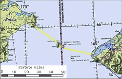
Possible route of a bridge or tunnel across the Bering Strait.
In April 2007 the Russian government announced that it was considering building a rail tunnel under the Bering Strait between Chukotka and Alaska. The tunnel, as projected, would be 60 miles (100km) long and would include oil and gas pipelines, fiber optic cables and power lines.[2] The tunnel project was estimated to cost $65 billion and take 15–20 years to build. In addition to the Russian government, sponsors of the project apparently include Transneft and RAO United Energy Systems.[3]
South of Guatemala, there are numerous breaks of gauge, such as 1,067mm (3ft6in) (with Honduras), and El Salvador (which uses the same 914mm gauge of rail, but is currently closed, with some sections abandoned and unusable). Nicaragua has also closed its rail network in 1996, though the majority of it was 1,067mm (3ft6in) gauge, with some 1,435mm (4ft8+1⁄2in) lines along the Atlantic Coast. Costa Rica's railroads are of 1,067mm (3ft6in) gauge, along with a private 600mm (1ft11+5⁄8in) gauge railroad at 3.5km in length. The railroads of Panama are connected to Costa Rica.[citation needed] The country had two gauges: originally broad gauge1,524mm (5ft), which was converted to standard gauge (1,435mm (4ft8+1⁄2in)) in 2000, and narrow gauge (914mm). Like the situation with roads, the Darién Gap is a formidable obstacle to railroads, and no railways cross it into South America.
The United States road network is the largest in the world, with 6.4 million km (4 million mi) of roadways. 75,360km (46,830mi) of those are Interstate Highways, and around another 200,000km (120,000mi) are U.S. Highways. The Interstate Highway system is almost completely composed of multi-lane, dual-carriagewayfreeways. The contiguous United States are also connected to its exclave, Alaska, via the Alaska Highway, which links the state to Yukon Territory, British Columbia, and the Lower 48 states. The continental United States is disconnected from the state of Hawaii and various insular areas in the Caribbean and Oceania.
The Trans Canada Highway spans the country along with its auxiliary branches. The Yellowhead Highway branches to the north, and the Crowsnest Highway, acts as a southern spur or shortcut to traveling from Alberta to British Columbia across the Rocky Mountains. Canada's national highways are similar to the US Route network, as it is mostly two-lane without freeway sections, aside from in and near large population centres, such as Montreal, Calgary, and Edmonton. Canada and the United States have also built the vital Alaska Highway, linking Anchorage, Alaska (and the rest of the state) to Canada and the rest of the United States.
Although Canada does not have a federal-level network of expressways, provinces from Ontario to Nova Scotia are inter-linked by provincial-level freeways: Ontario's 400-series highways network, Quebec's Autoroute network, New Brunswick's upgrades to its portions of the Trans-Canada Highway, and Nova Scotia's 100-series highways. These expressways are the provincial equivalents to the United States' Interstate Highway system. The only gap in this inter-provincial expressway network (one can travel from Windsor to Halifax using expressways, but this involves crossing into the United States to use their Interstate Highway network, and back into Canada) between Windsor, Ontario, and Halifax, Nova Scotia, is along Route 185/Autoroute 85, which is being twinned and upgraded to become a fully divided expressway. This gap is quite busy and is expected to be upgraded by 2026.
Provinces from Manitoba west have their own networks of highways (the majority of which are not expressways or divided highways), with Winnipeg also having its own Winnipeg City Routes. Alberta has its own small but growing inter-connected network of divided highways and freeways, such as Alberta Highway 1, Highway 2, and Highway 16. British Columbia also has a small network of freeways linking Vancouver to Kamloops, via Highway 1, and Highway 5, formerly a toll road.
Newfoundland and Labrador
In 2004 the provincial government studied the feasibility of a Newfoundland-Labrador fixed link joining the island of Newfoundland to the mainland of North America via a 17km-long rail tunnel under the Strait of Belle Isle, which would also carry automobile traffic on flat cars, similar to the Channel Tunnel between the United Kingdom and France. This has stalled due to the lack of a large road network and a lack of rail lines in Labrador, and the remoteness of the area on both sides of the strait in Newfoundland and Labrador. Another issue to contend with is that Newfoundland had abandoned its segments of its CN/Newfoundland Railway lines (3ft 6in or 1,070mm narrow-gauge) in 1988–1990, turning it into the Newfoundland T'Railway, a rail trail spanning the entire island. An automobile tunnel would be most likely unfeasible due to the length needed to cross the strait, and the difficulties of removing automobile exhaust and bringing in fresh air via large circulation fans throughout the tunnel. Labrador is, however, connected to the continental road network via the Trans-Labrador Highway.
Mexico also has a very large road network, 323,977km worth of roads. Of these, 96,221km are paved (this is including 6,335km of expressways) The remainder (227,756km worth) is unpaved. Since 1991, Mexico has been building toll roads that link its major cities together. Currently, there are 6,335km worth of toll freeways in the country, with the numbering scheme of n-D (n being the number of the road bypassed, such as 45, with toll freeway as 45-D, meaning 45 Diversion).
Central America
Central America's roadway network continues, linking every major city and capital, via the Pan-American Highway, which continues through Panama, across the Panama Canal, to Yaviza, Panama. It is separated from South America by the large Darién Gap.
The waterways remained important since Christopher Columbus arrived in 1492, right up until the First World War. Though their use has diminished somewhat with the arrival of rail transportation, the Interstate Highway/400 series highways networks of America and Canada, and with the debut of air travel, they are still widely used for transporting goods from the American Midwest to overseasmarkets.
The nation of Panama currently operates one of the world's busiest and most familiar waterways, the Panama Canal. This canal cuts through the Isthmus of Panama, connecting the Atlantic and Pacific Oceans, shaving off more than 9,000 miles (14,000km) for ships, instead of having them travel around the tip of Cape Horn in South America. A ship travelling from New York City to San Francisco would be roughly 9,500km (5,900mi) in distance, while a trip around Cape Horn would be 22,500km (14,000mi) in length. The Canal functions similarly to the Suez Canal in Egypt.
Air travel first entered as a viable alternative to transcontinental railroads, and to the then-primitive (or non-existent) road networks that crossed the United States and Canada in the early 1930s, but truly increased in popularity after the Second World War.
This page is based on this Wikipedia article Text is available under the CC BY-SA 4.0 license; additional terms may apply. Images, videos and audio are available under their respective licenses.