The Alaska Highway (French: Route de l'Alaska; also known as the Alaskan Highway, Alaska-Canadian Highway, or ALCAN Highway) is a highway in North America which was constructed during World War II to connect the contiguous United States with Alaska through Canada. It begins at the junction with a few Canadian highways in Dawson Creek, British Columbia, and runs to Delta Junction, Alaska, via Whitehorse, Yukon. When it was completed in 1942, it was about 1,700 miles (2,700 kilometres) long, but in 2012, it was only 1,387mi (2,232km). This is due to the realignments of the highway over the years, which has rerouted and straightened many sections. The highway opened to the public in 1948.[2] Once legendary for being a rough, challenging drive, the highway is now paved over its entire length.[1] Its component highways are British Columbia Highway 97, Yukon Highway 1, and Alaska Route 2.
An informal system of historic mileposts developed over the years to denote major stopping points. Delta Junction, at the end of the highway, makes reference to its location at "Historic Milepost 1422".[1] It is at this point that the Alaska Highway meets the Richardson Highway, which continues 96mi (155km) to the city of Fairbanks. This is often regarded, though unofficially, as the northwestern portion of the Alaska Highway, with Fairbanks at Historic Milepost 1520.[1] Mileposts on this stretch of highway are measured from the port of Valdez on Prince William Sound, rather than the Alaska Highway. The Alaska Highway is popularly (but unofficially) considered part of the Pan-American Highway, which extends south (despite its discontinuity in Panama) to Argentina.[3]
History
Proposal
Overview map for routes A and B, 1938
Proposals for a highway to Alaska originated in the 1920s. Thomas MacDonald, director of the U.S. Bureau of Public Roads, dreamed of an international highway spanning the United States and Canada. In order to promote the highway, in 1933 Slim Williams originally traveled the proposed route by dogsled. Since much of the route would pass through Canada, support from the Canadian government was crucial. However, the Canadian government perceived no value in putting up the required funds to build the road, since the only part of Canada that would benefit was not more than a few thousand people in Yukon.[citation needed]
In 1929, the British Columbia government proposed a highway to Alaska to encourage economic development and tourism. American President Herbert Hoover appointed a board with American and three Canadian members to evaluate the idea. Its 1931 report supported the idea for economic reasons, but both American and Canadian members recognized that a highway would benefit the American military in Alaska. In 1933, the joint commission proposed the U.S. government contribute $2 million of the capital cost, with the $12 million balance borne by the Canadian and BC governments.[5] The Great Depression and the Canadian government's lack of support caused the project to not proceed.[citation needed]
When the United States approached Canada again in February 1936, the Canadian government refused to commit to spending money on a road connecting the United States. The Canadians also worried about the military implications, fearing that in a war between Japan and the United States, the US military use of the road would breach Canadian neutrality. During a June 1936 visit to Canada, President Franklin D. Roosevelt told Prime Minister W. L. M. King that a highway to Alaska through Canada could be important in quickly reinforcing the American territory during a foreign crisis. Roosevelt became the first American to publicly discuss the military benefits of a highway in an August speech in Chautauqua, New York. He again mentioned the idea during King's visit to Washington in March 1937, suggesting that a $30 million highway would be helpful as part of a larger defense against Japan that would include, the Americans hoped, a larger Canadian military presence on the Pacific coast. Roosevelt remained a supporter of the highway, telling Cordell Hull in August 1937 that he wanted a road built as soon as possible.[6] By 1938, Duff Pattullo, the BC premier, favored a route through Prince George. The U.S. offered either a $15 million interest-free loan, or to cover half the construction costs.[5]
Northwest Service Command SSI
The December 7, 1941 attack on Pearl Harbor and beginning of the Pacific Theater in World War II, coupled with Japanese threats to the west coast of North America and the Aleutian Islands, changed the priorities for both nations. On February 6, 1942, the construction of the Alaska Highway was approved by the United States Army and the project received the authorization from the U.S. Congress and Roosevelt to proceed five days later. The Northwest Service Command was created in September 1942. It was responsible for the construction and maintenance of the Alaska Highway, the operation of the railway between Skagway, Alaska, and Whitehorse, and the Canol Project. Canada agreed to allow construction as long as the United States bore the full cost, and that the road and other facilities in Canada be turned over to Canadian authority after the war ended. It proved unimportant for the military because 99 percent of the supplies to Alaska during the war were sent by sea from San Francisco, Seattle, and Prince Rupert.[7][bettersourceneeded]
Brigadier General William M. Hoge, commanding general of the Alaska Highway Project, 1942A caterpillar tractor with dozer widens the roadway of the Alaska Highway, 1942Soldiers of the U.S. Army Corps of Engineers meeting in the middle after completing construction of the Alaska Highway
The Canadians favored Route B. This also started at Prince George, but followed the Rocky Mountain Trench up the valleys of the Parsnip and Finlay Rivers to Finlay Forks and Sifton Pass, then north to Frances Lake and the Pelly River in the Yukon. From there it went to Dawson City and down the Yukon Valley to connect the Richardson Highway to Fairbanks. The advantages of this inland route was the safe distance from enemy planes, and 209 miles (336km) shorter with lower elevations enabling lower construction and maintenance costs. The disadvantages were the bypassing of respective airbases, and Whitehorse, the principal town in the Yukon. Optional variations in the southern portion of this route were via Vanderhoof to the west or Monkman Pass to the east.[citation needed]
Route C, the Prairie option, advocated by the United States Army Corps of Engineers, was the only practical one. It was far enough inland from enemy planes and it linked the airfields of the Northwest Staging Route that conveyed lend-lease aircraft from the United States to the Soviet Union. This option encountered more level terrain, not ascending a pass over 4,250 feet (1,300m). There was also a railhead at Dawson Creek, British Columbia, and a winter trail from there to Fort Nelson, 300 miles (480km) to the northwest. It followed the Rocky Mountain Trench toward Dawson City before turning west to Fairbanks.[8]
Construction
The road was originally built mostly by the U.S. Army Corps of Engineers as a supply route during World War II. In 1942, the Army Corps of Engineers assigned more than 10,000 men, about a third of whom were black soldiers, members of three newly formed African-American segregated regiments.[9] There were four main thrusts in building the route: southeast from Delta Junction, Alaska, toward a linkup at Beaver Creek, Yukon; north then west from Dawson Creek (an advance group started from Fort Nelson, British Columbia, after traveling on winter roads on frozen marshland from railway stations on the Northern Alberta Railways); both east and west from Whitehorse after being ferried in via the White Pass and Yukon Route railway. The Army commandeered equipment of all kinds, including local riverboats, railway locomotives, and housing originally meant for use in southern California.[citation needed]
The official start of construction took place on March 9, 1942, after hundreds of pieces of construction equipment were moved on priority trains by the Northern Alberta Railways to the northeastern part of British Columbia near Mile 0 at Dawson Creek. Construction accelerated through the spring as the winter weather faded away and crews were able to work from both the northern and southern ends; they were spurred on after reports of the Japanese invasion of Kiska Island and Attu Island in the Aleutians. During construction the road was nicknamed the "oil can highway" by the work crews due to the large number of discarded oil cans and fuel drums that marked the road's progress.[10] The construction crew had also passed through an Indigenous village known as Champagne (Shadhala-ra) which they used to set up camp.[11] Unfortunately, disease spread and nearly wiped out the indigenous population of the village.[11][12] After the war, the survivors left the village to find work, leaving the location a ghost town.[11][12]
Group dedicating the Alaskan Highway (November 20, 1942)
On September 24, 1942, crews from both directions met at Mile 588 at what became named Contact Creek,[13] at the British Columbia-Yukon border at the 60th parallel; the entire route was completed October 28, 1942, with the northern linkup at Mile 1202, Beaver Creek, and the highway was dedicated on November 20, 1942, at Soldier's Summit.
Although it was completed on October 28, 1942, and its completion was celebrated at Soldier's Summit on November 21 (and broadcast by radio, the exact outdoor temperature censored due to wartime concerns), the "highway" was not usable by general vehicles until 1943. Even then there were many steep grades, a poor surface, switchbacks to gain and descend hills, and few guardrails. Bridges, which progressed during 1942 from pontoon bridges to temporary log bridges, were replaced with steel bridges where necessary.[citation needed]
A replica log bridge, the Canyon Creek bridge, can be seen at the Aishihik River crossing; the bridge was rebuilt in 1987 and refurbished in 2005 by the Yukon government where it functions as a popular tourist attraction. The easing of the Japanese invasion threat resulted in no more contracts being given to private contractors for upgrading of specific sections.[citation needed]
Some 100 miles (160km) of route between Burwash Landing and Koidern, Yukon, became nearly impassable in May and June 1943 due to permafrost thawing under the road and destroying the layer of delicate vegetation that held the road together. A corduroy road was built to restore the route, and corduroy still underlies old sections of highway in the area. Modern construction methods do not allow the permafrost to thaw, either by building a gravelberm on top or replacing the vegetation and soil immediately with gravel. The Burwash-Koidern section, however, is still a problem as the new highway built there in the late 1990s continues to experience frost heave.[citation needed]
The original agreement between Canada and the United States regarding construction of the highway stipulated that its Canadian portion be turned over to Canada six months after the end of the war.[16] In the postwar settlement, Canada did not pay for the highway itself, but assumed responsibility for its ongoing maintenance; furthermore, Canada compensated the United States for associated airfields, telephone lines, and other assets.[17][18] The handover took place on April 1, 1946, when the U.S. Army transferred control of the road through Yukon and British Columbia to the Canadian Army, Northwest Highway System. The Alaskan section was completely paved during the 1960s. The lower 50 miles of the Canadian portion were paved in 1959,[19] but the remainder was largely gravel. While the entire route is now completely paved (mostly with bituminous surface treatment), as late as the mid-1980s the highway still included sections of winding dusty road sandwiched between high quality reconstructed paved segments.[20]
The Milepost, an extensive guide book to the Alaska Highway and other highways in Alaska and Northwest Canada, was first published in 1949 and continues to be published annually as the foremost guide to travelling the highway.[citation needed]
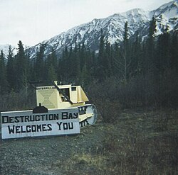
The settlement of Destruction Bay was originally a work camp for the highway.
The British Columbia government owns the first 82.6 miles (132.9km) of the highway, the only portion paved during the late 1960s and 1970s. Public Works Canada manages the highway from Mile 82.6 (km 133) to Historic Mile 630. The Yukon government owns the highway from Historic Mile 630 to Historic Mile 1016 (from near Watson Lake to Haines Junction), and manages the remainder to the U.S. border at Historic Mile 1221. The State of Alaska owns the highway within that state (Mile 1221 to Mile 1422).[citation needed]
The Alaska Highway was built for military purposes and its route was not ideal for postwar development of northern Canada.[21] Rerouting in Canada has shortened the highway by about 35 miles (56km) since 1947, mostly by eliminating winding sections and sometimes by bypassing residential areas. The historic milepost markings are therefore no longer accurate but are still important as local location references. Some old sections of the highway are in use as local roads, while others are left to deteriorate and still others are plowed up. Four sections form local residential streets in Whitehorse and Fort Nelson, and others form country residential roadways outside of Whitehorse. Although Champagne, Yukon, was bypassed in 2002, the old highway is still completely in service for that community until a new direct access road is built.[citation needed]
Rerouting continues, expected to continue in the Yukon through 2009[needs update], with the Haines Junction-Beaver Creek section covered by the Canada-U.S. Shakwak Agreement. The new Donjek River bridge was opened September 26, 2007, replacing a 1952 bridge. Under Shakwak, U.S. federal highway money is spent for work done by Canadian contractors who win tenders issued by the Yukon government. The Shakwak Project completed the Haines Highway upgrades in the 1980s between Haines Junction and the Alaska Panhandle, then funding was stalled by Congress for several years.[citation needed]
The Milepost shows the Canadian section of the highway now to be about 1,187 miles (1,910km), but the first milepost inside Alaska is 1222. The actual length of the highway inside Alaska is no longer clear because rerouting, as in Canada, has shortened the route, but unlike Canada, mileposts in Alaska are not recalibrated. The BC and Yukon governments and Public Works Canada have recalibrated kilometre posts. The latest BC recalibration was carried out in 1990; using its end-point at the border at Historic Mile 630, the Yukon government has recalibrated in three stages: in 2002, from Mile 630 to the west end of the Champagne revision; in fall 2005, to a point just at the southeast shore of Kluane Lake, and in fall 2008, to the border with Alaska.[citation needed]
There are historical mileposts along the B.C. and Yukon sections of the highway, installed in 1992, that note specific locations, although the posts no longer represent accurate driving distance. There are 80 mileposts in B.C., 70 in Yukon and 16 in Alaska with a simple number marker of the original mile distance. There are 31 "historic signs" in B.C., 22 in Yukon and 5 in Alaska, identifying the significance of the location. There are 18 interpretive panels in B.C., 14 in Yukon and 5 in Alaska which give detailed text information at a turn-off parking area.[citation needed]
A monument at the southern terminus of the Alaska Highway (Dawson Creek)
The Canadian section of the road was delineated with mileposts, based on the road as it was in 1947, but over the years, reconstruction steadily shortened the distance between some of those mileposts. In 1978, metric signs were placed on the highway, and the mileposts were replaced with kilometre posts at the approximate locations of a historic mileage of equal value, e.g. km post 1000 was posted about where historical Mile 621 would have been posted.[citation needed]
As reconstruction continues to shorten the highway, the kilometre posts, at 2-kilometre (1.2mi) intervals, were recalibrated along the B.C. section of road to reflect the driving distances in 1990. The section of highway covered by the 1990 recalibration has since been rendered shorter by further realignments, such as near Summit Pass and between Muncho Lake and Iron Creek.[citation needed]
View of the highway at Mile 1,337, facing east
Based on where those values left off, new Yukon kilometre posts were erected in fall 2002 between the B.C. border and the west end of the new bypass around Champagne, Yukon; in 2005, additional recalibrated posts continued from there to the east shore of Kluane Lake near Silver City; and in fall 2008, from Silver City to the boundary with Alaska. Old kilometre posts, based on the historic miles, remained on the highway, after the first two recalibrations, from those points around Kluane Lake to the Alaska border. The B.C. and Yukon sections also have a small number of historic mileposts, printed on oval-shaped signs, at locations of historic significance; these special signs were erected in 1992 on the occasion of the highway's 50th anniversary.[citation needed]
The Alaska portion of the highway is still marked by mileposts at 1-mile (1.6km) intervals, although they no longer represent accurate driving distance, due to reconstruction.[citation needed]
A monument at the northern terminus of the Alaska Highway (Delta Junction)
The historic mileposts are still used by residents and businesses along the highway to refer to their location, and in some cases are also used as postal addresses. The community Wonowon, British Columbia, is named by its location at mile 101, spoken "one-oh-one".[citation needed]
Residents and travelers, and the government of the Yukon, do not use "east" and "west" to refer to direction of travel on the Yukon section, even though this is the predominant bearing of the Yukon portion of the highway; "north" and "south" are used, referring to the south (Dawson Creek) and north (Delta Junction) termini of the highway. This is an important consideration for travelers who may otherwise be confused, particularly when a westbound travel routes southwestward or even due south to circumvent a natural obstacle such as Kluane Lake.[citation needed]
Some B.C. sections west of Fort Nelson also route more east-to-west, with southwest bearings in some section; again, "north" is used in preference to "west".[citation needed]
Since 1949, The Milepost, an exhaustive guide to the Alaska Highway and all other routes through the region, has been published each year.[citation needed]
The portion of the Alaska Highway in Alaska was planned to become part of the United States Numbered Highway System and to be signed as part of U.S. Route 97 (US97). In 1953, the British Columbia government renumbered a series of highways to Highway97 between the U.S. border at Osoyoos, US97's northern terminus, and Dawson Creek.[citation needed] The Alaska International Rail and Highway Commission lobbied for the designation of Highway 97 from Fairbanks to Mexico City in the late 1950s.[24] Certain prior editions of United States Geological Survey topographic maps, mostly published during the 1950s, bore the US97 highway shield along or near portions of the current AK-2.[25] In 1964, the American Association of State Highway and Transportation Officials (AASHTO) approved an extension of US97 from the Yukon border to Fairbanks along AK-2, conditional to Yukon renumbering its portion of the Alaska Highway;[23] the Yukon government declined to renumber its portion of the highway and approval was withdrawn in 1968.[25]
The pioneer road completed in 1942 was about 1,680 miles (2,700km) from Dawson Creek to Delta Junction. The Army then turned the road over to the Public Roads Administration (PRA), which then began putting out section contracts to private road contractors to upgrade selected sections of the road. These sections were upgraded, with removal of excess bends and steep grades; often, a traveler could identify upgraded sections by seeing the telephone line along the PRA-approved route alignment. When the Japanese invasion threat eased, the PRA stopped putting out new contracts. Upon hand-off to Canada in 1946, the route was 1,422 miles (2,288km) from Dawson Creek to Delta Junction.
The route follows a northwest then northward course from Dawson Creek to Fort Nelson. On October 16, 1957, a suspension bridge crossing the Peace River just south of Fort St. John collapsed. A new bridge was built a few years later. At Fort Nelson, the road turns west and crosses the Rocky Mountains, before resuming a westward course at Coal River. The highway crossed the Yukon-BC border nine times from Mile 590 to Mile 773, six of those crossings were from Mile 590 to Mile 596. After passing the south end of Kluane Lake, the highway follows a north-northwest course to the Alaska border, then northwest to the terminus at Delta Junction.
Postwar rebuilding has not shifted the highway more than 10 miles (16km) from the original alignment, and in most cases, by less than three miles (4.8km). It is not clear if it still crosses the Yukon-BC border six times from Mile 590 to Mile 596.[why?]
Mile 1348,[32] one 2.5-mile (4.0km) bypassed section of the original route, about 37 miles (60km) southeast of Delta Junction, is listed on the National Register of Historic Places as "one of the few sections of the road in Alaska virtually unchanged". The unpaved road is used by local residents to access Craig Lake,[33][34] and is signed as Craig Lake Trail.
Other former segments have deteriorated and are no longer usable. More recent construction projects have deliberately plowed up roadway to close it.[citation needed]
↑Perras, Galen Roger (1998). Franklin Roosevelt and the Origins of the Canadian-American Security Alliance, 1933–1945: Necessary, but Not Necessary Enough. Praeger. pp.19–22, 34–36. ISBN0-275-95500-1.
↑Conn, Stetson; Fairchild, Byron. "Chapter XV, The United States and Canada: Elements of Wartime Collaboration". The Framework of Hemisphere Defense. United States Army in World War II: The Western Hemisphere. Washington, DC: Office of the Chief of Military History, Department of the Army. OCLC1036066. Archived from the original on December 31, 2010. Retrieved April 17, 2008.
↑Coates, K.; Morrison, W. R. (1991). "The American Rampant: Reflections on the Impact of United States Troops in Allied Countries during World War II". Journal of World History. 2 (2): 201–221. JSTOR20078500.
↑"Yukon Highways Given Numbers". The Whitehorse Star. April 25, 1968. p.21. Retrieved December 24, 2019– via Newspapers.com.
↑Cypher Consulting (July 2015). Landmark Kilometre Inventory(PDF) (Report). British Columbia Ministry of Transportation and Infrastructure. pp.452–461. Archived from the original(PDF) on June 1, 2016. Retrieved October 20, 2017.
↑Alaska Department of Transportation and Public Facilities (April 25, 2006). Northern Region General Log(PDF). Routes 153000 (Elliott Highway), 152000 (Steese Highway), 190000 (Richardson Highway), and 180000 (Alaska Highway).[permanent dead link]
This page is based on this Wikipedia article Text is available under the CC BY-SA 4.0 license; additional terms may apply. Images, videos and audio are available under their respective licenses.