Chetwynd/ˈtʃɛtwɪnd/ is a district municipality located in the eastern foothills of the Rocky Mountains, in northeastern British Columbia, Canada. Situated on an ancient floodplain, it is the first town eastbound travellers encounter after emerging from the Rockies along Highway 97, and acts as the gateway to the Peace River Country. The town developed during the construction of infrastructure through the Rocky Mountains in the 1950s; additionally, it was used as a transshipment point during the building of hydroelectric dams, in the 1960s and 1970s, and the new town of Tumbler Ridge, in the early 1980s. Home to approximately 2,600 residents, the town’s population has increased little—if at all—since the 1980s, but is significantly younger than the provincial average.[5]
Once known as Little Prairie, the community adopted its name in honour of provincial politician Ralph Chetwynd, just prior to its incorporation, in 1962. The 64-square-kilometre (25sqmi) municipality consists of the town, a community forest, and four exclave properties. Chetwynd has dozens of chainsaw carvings displayed throughout the town as public art. It is home to a Northern Lights College campus. Nearby, there are four provincial parks, two lakes, and several recreational trails.
Highways 29 and 97 intersect in town; the east–west Highway 97 connects the town to Prince George and Dawson Creek while the north–south Highway 29 connects Tumbler Ridge and Hudson's Hope. A rail line branches-off in three directions: northward to Fort St. John, east to Dawson Creek, and west through the Rockies to Prince George. The Chetwynd economy is dominated by the primary industries of forestry, fossil fuel extraction, and transportation. Chetwynd is a member municipality in the Peace River Regional District and, as of 2021[update], is represented in provincial politics by BC United MLA Mike Bernier (elected in 2013).
History
From 1918 until the 1930s, the present townsite hosted a trading post on a grassy pasture known to the Sekani and Saulteaux as Little Prairie.[6] In the 1920s, settlers from the Peace River Country began migrating westwards across the frozen Kiskatinaw and Pine Rivers to lands assigned under the Dominion Lands Act for homesteading. Little Prairie was homesteaded in 1930 by Alexander and Lillan Windrem who cleared the land by 1935 for hay, oats and gardens.[7] Oil and coal discoveries, west of Little Prairie, near Commotion Creek, led to the construction of area roads. As the area's natural resource potential became more apparent, a highway was planned in the late 1940s from the British Columbia Interior to the northern side of the Rocky and Omineca Mountains. The John Hart Highway, named after John Hart, a former British Columbia premier, was completed in 1952; designated Highway 97S it stretches from Prince George to Dawson Creek, with an intersection at Little Prairie. This was northeastern Britis Columbia's first connection with the rest of the province; previously a trip through the neighbouring province of Alberta was required. Following the opening of the highway, businesses such as restaurants and service stations were opened in Little Prairie to accommodate incoming workers and settlers. The first school was built in 1951.[6]
Little Prairie was incorporated as a waterworks district on 8 October 1957; within the span of a few years a rail line, natural gas pipeline, and telephone line were built along the highway from Prince George. Provincial Minister of Railways Ralph Chetwynd (who also directed the Pacific Great Eastern Railway) headed the rail line project. The rail line continued eastward to Dawson Creek which was the westernmost terminus of Northern Alberta Railways. In early 1958, the first train ceremonially arrived in Little Prairie from Vancouver. Its load included pipe to symbolize natural gas development, steel railway track for the extension of the rail line, box cars for grain and lumber, and a truck representing freight hauling along the Alaska Highway.[8] The railway station in Little Prairie was completed in 1959 and named after Chetwynd, who had died two years earlier. Soon afterwards the post office adopted this name.
Chetwynd became the community's official name on 1 July 1959. In 1960, the Chetwynd Waterworks District expanded its mandate to include garbage disposal, fire protection, and street lighting. Led by its Chamber of Commerce, the community incorporated as a municipality on 25 September 1962.[9] The application for incorporation estimated Chetwynd's population as 750—inclusive of nearby work camps.[6] The 1966 Canadian census, the first to recognize Chetwynd as a census subdivision, counted 1,368residents.[10]
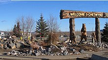
Sign and chainsaw carvings along Highway 97 welcoming travellers going east
Growth continued in the 1960s when the town served as the rail-to-truck transshipment point for delivering workers and supplies to the construction site of the W. A. C. Bennett Dam in nearby Hudson's Hope. Canfor and West Fraser Timber bought sawmills in 1964 and 1971, respectively, and eventually became two of the town's largest employers. The development of its forestry sector led to the town being declared the Canadian Forest Service's 1992 Forestry Capital of Canada.[11] The community opened a rodeo ground and curling rink in 1963, a library in 1967, a new fire hall in 1968, an airport in 1970 and a hospital in 1971.[6]
Further growth was stoked in the late 1970s and early 1980s by the construction of the Peace Canyon Dam near the Bennett Dam, the opening of the natural gas and sulphur plant, and the construction of a mining town Tumbler Ridge. Chetwynd thus was re-incorporated as a district in 1983 with a population of 2,957.[12] With no more megaprojects, Chetwynd's population remained relatively stable at about 3,000, with a peak population in 1996 at 3,113.[13]
In 1983, Andrea Scherpf and Bernd Göricke were murdered near Chetwynd in 1983. They had been hitchhiking in western Canada in the fourth quarter of 1983. In early October, they accepted a ride in a 1960s Chevrolet pick-up. The unidentified driver shot and killed the couple, then dumped the bodies 32 kilometres (20mi) west of the community. A Canadian was convicted of the murders in 1991 but was later exonerated by DNA evidence and released. The case remains unsolved.[14][15][16][17][18]
On 4 December 1996, Chetwynd's boundaries were expanded to include 49 square kilometres (19sqmi) of forested land and industrial properties.[19] Most of this came from moving the northern border up 210 metres (690ft) over Ol' Baldy Ridge to create a community forest, a concept which originated from a Chetwynd Secondary School proposal in 1980 for a fitness trail. The trail became the backbone of a system of interconnected trails and greenspaces that went up the ridge. Four industrial properties—a gas plant, sulfur processing plant, coal mine, and pulp mill—became exclaves of the district as they incorporated to receive municipal services. The coal mine, with an expected lifespan of 15 years, was approved by the province for development in 1998. It was not constructed until 2004, making it the province's first new coal mine in 20 years. It only operated for two years before closing due to poor yields, equipment failure, and lack of financial backing.[20][21]
Geography and climate
Carved out of an ancient floodplain, the small terrace upon which Chetwynd is situated lies in the northern foothills of the Rocky Mountains. Once used as a grazing spot by nomadic Aboriginals, the terrace was farmed by settlers until it was developed into a town. Two types of soil—namely, the Widmark and Centurion Series—comprise the terrace's surface. The Widmark Series—a moderately well-drained degraded loamy, woody, silty, and clay-like soil—lies north of Highway 97. Meanwhile, the Centurion Series—which lies south of the highway—is a poorly drained soil with a dark-brown peaty surface material consisting of decomposed leaves and mosses. These soils, also limited by topography and stoniness, are generally used for forage and pasture.[22][23]
The District of Chetwynd with main townsite and four exclave properties
The town is surrounded by forested hills but the prairies of the Peace River Country begin here and continue eastward into Alberta. It lies in a transition area dividing two biogeoclimatic regions: the Boreal White and Black Spruce zone and the Engelmann Spruce-Subalpine Fir zone.[24][25] The regions surrounding Chetwynd and Dawson Creek contain caribou herds, although the total number of caribou have decreased in the first two decades of the 21st century.[26] One factor of the caribou's decline is the large number of wolves who prey on the caribou; in 2014 the British Columbian government began a wolf-culling program to reduce the number of wolves in the region.[27] The region also contains moose, whose numbers have increased due to improved habitats caused by cutting down trees for the logging industry. The area surrounding Chetwynd was affected by a pine beetle infestation, which caused timber mills to reduce their operations in the region.[28]
The town experiences a cool continental climate, including cold winters and warm summers. Southwesterly winds, coming off Williston Lake, predominate, with wind speeds averaging around 8.2 kilometres per hour (5.1mph).[29] About 318 millimetres (12.5in) of rain and 169 centimetres (67in) of snow fall on the town annually and about 30 days with some fog are expected per year.[29] Chetwynd, like the rest of the Peace River Regional District, uses Mountain Standard Time year-round. The remainder of the province uses Pacific Time with daylight saving time, meaning that Chetwynd shares the same time with the province during the summer and is one hour ahead during the winter.[30]
Note: 1976 population figure is adjusted due to boundary changes.[4][32][10]
In the 2021 Canadian census conducted by Statistics Canada, Chetwynd had a population of 2,302 living in 993 of its 1,271 total private dwellings, a change of -8% from its 2016 population of 2,503. With a land area of 63.55 square kilometres (24.54sqmi), it had a population density of 36.2/km2 (93.8/sqmi) in 2021.[4]
According to the 2021 census, Chetwynd had a median age almost seven years lower than the province's median. English is the mother tongue of nearly all (87.1%) residents of Chetwynd, which includes a small population (1.3%) of French speakers. There are about 3.7% native Tagalog speakers, and 0.4%Cree language speakers. Only 10.3% of Chetwynd residents are immigrants, which is considerably lower than the provincial average of 29%. The largest immigrant group comes from the Philippines, representing 40.4% of all immigrants to the municipality.[4]
Residents of Chetwynd with no certificate, diploma, or degree make up 20.7% of the population compared to the provincial average of 13.5%. However, those with a secondary school diploma comprise 36.3% of the population compared to the provincial average of 29.5%, and those with a post-secondary certificate or diploma (below a bachelor's degree) comprise 32.9% of the population compared to the provincial average of 28.5%. There are significantly fewer residents with a bachelor's, or higher, degree in Chetwynd (10.3%) compared to the provincial average of 28.6%. Almost all commuters in Chetwynd commute by car, truck, or van (84.4%), which is higher than the provincial average of 79.9%.[4]
Ethnicity
As of 2021, there are few visible minorities in Chetwynd (11.6%) compared to the provincial average of 34.4% with Filipinos representing the largest visible minority as well with 125 residents (5.5% of the total population). Approximately 380, or 16.7%, of residents of Chetwynd considered themselves to have an Indigenous identity, much higher than the provincial average of 3.9%. The primary ethnic groups in Chetwynd were reported as: English (23.1%), Scottish (20.4%), German (17.8%), Irish (16.5%), French (12.5%), Métis (9.7%), Norwegian (9%), Canadians (8.4%), and First Nations (5.9%).[4]
Religion
According to the 2021 census, there were only two religious groups in Chetwynd along with those professing no religion:[4]
Irreligion (1,445 persons or 63.5% compared to 52.1% for the province)
Christianity (795 persons or 34.9% compared to 34.3% for the province)
Buddhism (15 persons or 0.7%compared to 1.7% for the province)
Economy
Chetwynd is the commercial centre for the rural communities of the Pine River Valley, as well as Moberly Lake, Jackfish Lake, and Lone Prairie. These rural residents are mostly cattle, sheep, and bison ranchers and use the town as a transportation hub to ship products via highways or rail. After the town was connected by rail and highway to the remainder of the province, the town's economy expanded, between 1950 and 1980, to include primary industries, including lumber mills (Chetwynd Forest Industries,[33]Canfor (Canadian Forest Industries), TembecPulp Mill), gas plants (Duke Energy, Talisman Energy), a coal processing plant (Pine Valley Mining), and a sulfur processing plant (Enersul). Since the late 1990s, Chetwynd has undergone an economic downturn from the closure of coal mines in Tumbler Ridge and the softwood lumber trade dispute between Canada and the United States, which led to the closure of the Louisiana-Pacific Canada Pulp Company pulp operations in 2001.[34]
The 2001 census recorded 1,120 income-earners over the age of 15 residing in Chetwynd; of these, 690 (62%) worked full-time throughout the year.[35]
Since then, the economy has rebounded with increased oil, gas and mineral exploration, tourist marketing of the area's outdoor recreational activities and chainsaw carvings program, new and re-opened coal mines, and wind farm construction.[36] Both the Dokie Ridge Wind Farm and Meikle Wind Farm were constructed.[37] In 2015, Paper Excellence bought the Tembec Mill, which had been idle since 2012, and invested $50 million in upgrades.[38] The mill opened in May 2015 only to undergo a maintenance shutdown in September of that year.[39]
Education
Chetwynd's roads, schools, and parks
The 2021 census estimated that 10.3% of people in Chetwynd between 20 and 64 years old graduated from a university, less than half of the 28.6% provincial average and 20.7% did not graduate from secondary school, 7.2% higher than the provincial average.[4] Chetwynd's schools are administered by School District 59 Peace River South, which operates one secondary school and three primary schools: Chetwynd Secondary School, Don Titus Elementary, Windrem Elementary, and Little Prairie Elementary.[40]Northern Lights College maintains a campus in Chetwynd, which has a 2003 enrolment of 170 students (based on full-time equivalents).[40] It was established in 1976 with eight general interest and two university transfer courses.[41][42]
Infrastructure
Looking east along Highway 97
The John Hart Highway portion of Highway 97 runs east–west through Chetwynd, connecting the town to Dawson Creek (102km[63mi] east) and Prince George (304km[189mi] south). Highway 29 (Don Philips Way) runs north–south through Chetwynd, connecting the town to Hudson's Hope (60km[37mi] north) and Tumbler Ridge (89km[55mi] southeast). The downtown core lies just west of the intersection of Highway 97 and Highway 29. Chetwynd's internal street network has 28 kilometres (17mi) of paved road,[43] which uses the highway as its main arterial road with parallel frontage roads for local trips. A site plan by the province in 1957 laid out the basic structure of the town.[6]
Chetwynd has rail, air, and bus service for regional and provincial transportation needs. Rail lines enter Chetwynd from three directions: from Fort St. John in the north, from Dawson Creek in the east, and from Prince George in the south. Pacific Great Eastern Railway (later BC Rail) ran passenger service to Chetwynd until 1990. Since then the trains have been used solely for moving resources such as lumber and coal. The District of Chetwynd has operated the unmanned Chetwynd Airport[44](IATA: YCQ) since 1970. The runway was paved in 1975 but only handles chartered flights and helicopters. A new airport terminal was constructed in 2008 by students at Northern Lights College.[45] The closest airports with commercial airlines are at Fort St. John Airport and Dawson Creek Airport. Until 2018 Greyhound Lines maintained a bus stop in town on their Vancouver−Prince George−Dawson Creek route.[46]
The District uses the northeast-flowing Pine River as both a source of drinking water and an outlet for sewage. The former comes from an intake pipe southwest of town.[40] Its sewerage consists of 28 kilometres (17mi) of sanitary sewers and 3 kilometres (1.9mi) of storm sewers.[43] Raw sewage is processed by a five-cell lagoon system and released into the Pine River south of town.[40] The water supply was briefly shut off in 2000 when an oil pipeline along the Pine River ruptured, spilling 990 cubic metres (6,200bbl) of oil into the river.[47][48] Electricity is supplied by BC Hydro from the W. A. C. Bennett and Peace Canyon dams and natural gas by Pacific Northern Gas. In 2019, the federal and provincial governments announced a joint project to increase electricity supply to the Peace Region. The project expands on existing infrastructure by building two 230 kilovolt transmission lines from the under-construction Site C dam and its substation to existing stations approximately 30 kilometres (19mi) east of Chetwynd.[49]
Culture and recreation
The Little Prairie Heritage Museum, located in one of the town's oldest buildings (a converted post office dating to 1949) displays artifacts and re-creations of the town's frontier times, and nostalgia pieces from the construction of infrastructure through the Rocky Mountains. A public art program, started in 1987, showcases over 50 chainsaw carvings spread throughout town with a downtown monument that declares Chetwynd the "Chainsaw Sculpture Capital of the World". The town's first annual chainsaw carving contest was held in June 2005. A regular contestant in the Communities in Bloom contest, the District built four wind turbines in 2004 to power decorative lights on 25 large trees along its boulevard as an entry to the WinterLights Celebration contest.[50] A statue of a lumberjack entitled "Chetwynd, the Little Giant of the Great Peace", measuring 2.7 metres (8ft 10in) tall and located alongside the highway, has stood in the town since 1967. The statue has been periodically altered by replacing the axe with other accessories, such as a lasso, rifle, gold pan and pitchfork, or dressed in other outfits, like a Santa suit.[6][51]
Ol' Baldy, locally known as Mount Baldy
For outdoor recreation, a community forest on Mount Baldy provides residents with trails for walking, hiking, cycling, and cross-country skiing close to home. There is downhill skiing about 100 kilometres (62mi) west of town (and closer to the Rocky Mountains) at the Powder King Mountain Resort. Nearby provincial parks include Gwillim Lake Provincial Park (56km[35mi] southeast), Moberly Lake Provincial Park (25km[16mi] northwest), Pine River Breaks Provincial Park (15km[9.3mi] east), East Pine Provincial Park (30km[19mi] east), and Pine Le Moray Provincial Park (70km[43mi] southwest).[52] Chetwynd has an indoor rodeo facility,[53] an outdoor speed skating oval, and a general recreation complex which has within it an ice arena, swimming pool and curling rink, among other facilities.[54]
Media
Since the 1970s, the Chetwynd Communications Society has worked to establish radio and television service. For many years, they rebroadcast pre-recorded content to Chetwynd and surrounding communities via a telecommunications tower on nearby Wabi Mountain. On 5 December 1996, 94.5 CHET-FM—the town's first radio station—went on-air. Since then the station has expanded with a repeater tower in Dawson Creek at 104.1 and is now known collectively as Peace FM. Its programming uses a series of specialty programs such as metal, gospel, hard rock, and dance. Chetwynd's community television station, CHET-TV channel 55, began broadcasting on 8 March 2000, in a ceremony attended by Adrienne Clarkson, then Governor General.[55] The Chetwynd Communications Society also owns a series of low-powered repeaters that rebroadcasts selected Canadian and American stations via satellite. In addition, Chetwynd is served by CBUZ-FM 93.5, repeating CBC Radio One station CBYG-FM from Prince George.[56][57]
Two periodicals covered local news: the weekly newspaper Chetwynd Echo and the biweekly newsletterCoffee Talk Express. The Chetwynd Echo was created by the Chamber of Commerce in 1959 as The Chinook in a tabloid format. It was renamed the Weekly Advertiser in 1962 and the Chetwynd Echo in 1971 when it switched to a broadsheet format.[58][59] The Chetwynd Echo closed in 2016, publishing its final edition on 6 January.[60]
Government and politics
Chetwynd municipal hall, fire hall, and ambulance bay
The District of Chetwynd's council-manager form of municipal government is headed by a mayor (who also represents Chetwynd on the Peace River Regional District's governing board) and a six-member council.[61] These positions, plus two school board trustees, are subject to at-large elections every three years. Mayor Allen Courtoreille was first elected in 2018.[62] He was preceded by Merlin Nichol (2011–2018) and Evan Saugstad (2003–2011),[63] and long-time mayor Charlie Lasser.[64] The city funds a volunteer fire department, which services the town and nearby rural communities. It also maintains the sewer, water, local road, sidewalk, street lighting, animal control, building inspection, park, and recreation services. The city also partially funds a ten officer Royal Canadian Mounted Police detachment, which covers the municipality and nearby rural communities.[65]
British Columbia is the westernmost province of Canada. Situated in the Pacific Northwest between the Pacific Ocean and the Rocky Mountains, the province has a diverse geography, with rugged landscapes that include rocky coastlines, sandy beaches, forests, lakes, mountains, inland deserts and grassy plains. British Columbia borders the province of Alberta to the east; the territories of Yukon and Northwest Territories to the north; the U.S. states of Washington, Idaho and Montana to the south, and Alaska to the northwest. With an estimated population of over 5.6million as of 2024, it is Canada's third-most populous province. The capital of British Columbia is Victoria, while the province's largest city is Vancouver. Vancouver and its suburbs together make up the third-largest metropolitan area in Canada, with the 2021 census recording 2.6million people in Metro Vancouver. British Columbia is Canada's third-largest province in terms of total area, after Quebec and Ontario.
Hudson's Hope is a district municipality in northeastern British Columbia, Canada, in the Peace River Regional District. Having been first settled along the Peace River in 1805, it is the third-oldest European-Canadian community in the province, although it was not incorporated until 1965. Most jobs in the economy are associated with the nearby W. A. C. Bennett Dam and Peace Canyon Dam, and timber logging.
Grande Prairie is a city in northwest Alberta, Canada within the southern portion of an area known as Peace River Country. It is located at the intersection of Highway 43 and Highway 40, approximately 456 km (283 mi) northwest of Edmonton. The city is surrounded by the County of Grande Prairie No. 1.
Fort St. John is a city located in northeastern British Columbia, Canada. The most populous municipality in the Peace River Regional District, the city encompasses a total area of about 22 km2 (8.5 sq mi) with 21,465 residents recorded in the 2021 Census. Located at Mile 47 of the Alaska Highway, it is one of the largest cities between Dawson Creek, British Columbia and Delta Junction, Alaska. Established in 1794 as a trading post, Fort St. John is the oldest European-established settlement in present-day British Columbia. The city is served by the Fort St. John Airport. The municipal slogan is Fort St. John: The Energetic City.
Highway 97 is a major highway in the Canadian province of British Columbia. It is the longest continuously numbered route in the province, running 2,081 km (1,293 mi) and is the only route that runs the entire north–south length of British Columbia, connecting the Canada–United States border near Osoyoos in the south to the British Columbia–Yukon boundary in the north at Watson Lake, Yukon.
Dawson Creek is a city in northeastern British Columbia, Canada. The municipality of 24.37 square kilometres (9.41 sq mi) had a population of 12,978 in 2016. Dawson Creek derives its name from the creek of the same name that runs through the community. The creek was named after George Mercer Dawson by a member of his land survey team when they passed through the area in August 1879. Once a small farming community, Dawson Creek became a regional centre after the western terminus of the Northern Alberta Railways was extended there in 1932. The community grew rapidly in 1942 as the US Army used the rail terminus as a transshipment point during construction of the Alaska Highway. In the 1950s, the city was connected to the interior of British Columbia via a highway and a railway through the Rocky Mountains. Since the 1960s, growth has slowed, but the area population has increased.
The Village of Pouce Coupe is a small town in northeastern British Columbia, Canada, and a member municipality of the Peace River Regional District. It was originally named 'Pouskapie's Prairie', after the name of the local native band chief. The 2.06-square-kilometre (0.80 sq mi) municipality is home to 792 residents.
The Peace River is a 1,923-kilometre-long (1,195 mi) river in Canada that originates in the Rocky Mountains of northern British Columbia and flows to the northeast through northern Alberta. The Peace River joins the Athabasca River in the Peace-Athabasca Delta to form the Slave River, a tributary of the Mackenzie River. The Finlay River, the main headwater of the Peace River, is regarded as the ultimate source of the Mackenzie River. The combined Finlay–Peace–Slave–Mackenzie river system is the 13th longest river system in the world.
Northern Alberta Railways was a Canadian railway which served northern Alberta and northeastern British Columbia. Jointly owned by both Canadian National Railway and Canadian Pacific Railway, NAR existed as a separate company from 1929 until 1981.
Peace River South is a provincial electoral district for the Legislative Assembly of British Columbia, Canada. It was created under the name South Peace River by the Constitution Amendment Act, 1955, which split the old riding of Peace River into northern and southern portions for the 1956 BC election. Its current name has been in use since 1991.
The District of Taylor is a district municipality in northeastern British Columbia, Canada, located at mile 36 of the Alaska Highway. Taylor, a member municipality of the Peace River Regional District, covers an area of about 17 km2 with 1,317 residents as of 2021.
The Peace River Regional District is a regional district in northeastern British Columbia, Canada. The regional district comprises seven municipalities and four electoral areas. Its member municipalities are the cities of Fort St. John and Dawson Creek, the district municipalities of Tumbler Ridge, Chetwynd, Taylor, and Hudson's Hope, and the village of Pouce Coupe. The district's administrative offices are in Dawson Creek.
Tumbler Ridge is a district municipality in the foothills of the B.C. Rockies in northeastern British Columbia, Canada, and a member municipality of the Peace River Regional District. With a population of 2,399 (2021) living in a townsite, the municipality encompasses an area of 1,558 km2 (602 sq mi) of mostly Crown land. The townsite is located near the confluence of the Murray River and Flatbed Creek and the intersection of Highway 52 and Highway 29 and includes the site of the Tumbler Ridge Secondary School and Tumbler Ridge Airport. It is part of the Peace River South provincial electoral district and the Prince George—Peace River—Northern Rockies federal riding.
The Peace River Country is an aspen parkland region centring on the Peace River in Canada. It extends from northwestern Alberta to the Rocky Mountains in northeastern British Columbia, where a certain portion of the region is also referred to as the Peace River Block.
Pine Le Moray Provincial Park is a provincial park in British Columbia, Canada. The park, 70 km southwest of Chetwynd covers 43,289 hectares. It is located within the Hart Ranges ecosection near the Rocky Mountains. It is within the Engelmann Spruce-Subalpine Fir biogeoclimatic zone. Water courses include Link and Mountain Creeks, the Pine River, and Heart Lake. It provides habitat for trout, Arctic grayling, mountain whitefish, high elevation caribou, moose, wolverine, and grizzly bear. It is recognized by the province as an area traditionally used by First Nations people. Its topography has examples of Karst topography and alpine areas.
The Municipal District of Greenview No. 16 is a municipal district (MD) in northwest Alberta, Canada. It covers the full extent of Census Division 18, and with an area of 32,984 km2 (12,735 sq mi), it is the largest municipal district in Alberta. Its administrative office is located in the Town of Valleyview.
Alberta Provincial Highway No. 49, commonly referred to as Highway 49, is a highway in northwestern Alberta, Canada. It runs east–west from the British Columbia border to Donnelly, and then north–south to Valleyview. Highway 49 has a total length of 266 kilometres (165 mi).
The Hart Ranges are a major subrange of the Canadian Rockies located in northeastern British Columbia and western Alberta. The mountains constitute the southernmost portion of the Northern Rocky Mountains.
The Pine Pass, in the Hart Ranges of the Northern Rockies of British Columbia, connects the Peace Country of the province's Northeastern Interior. Highway 97 and the Canadian National Railway (CNR) traverse this mountain pass, which is the location of the Bijoux Falls Provincial Park, the Pine Le Moray Provincial Park, and the Powder King Mountain Resort at Azouzetta Lake.
Pat Pimm is a Canadian politician, who was elected as a BC Liberal Member of the Legislative Assembly of British Columbia in the 2009 provincial election, and represented the riding of Peace River North. He has lived in Fort St. John, British Columbia and has a business background working at an instrumentation company that specializes in the oil and gas sector. He spent 12 years on the Fort St. John city council before his election to the Legislative Assembly. In the 39th Parliament of BC Pimm served on several committees and first became involved with the Executive Council in October 2010 when former B.C. Premier Gordon Campbell appointed Pimm as the Parliamentary Secretary for the Natural Gas Initiative under the Ministry of Energy. When Christy Clark became Premier of British Columbia in March 2011, she retained Pimm at the same position.
1 2 3 4 5 6 Bea Kurjata, ed. (1989). History book saga of Little Prairie-Chetwynd. Altona, Manitoba: Chetwynd and Area History Committee. pp.1–2, 66, 89–99, 515. ISBN0-88925-943-7.
↑ Shaw, John (1989). "The Windrems". History book saga of Little Prairie-Chetwynd. Altona, Manitoba: Chetwynd and Area History Committee. pp.1–2. ISBN0-88925-943-7.
↑ "Chetwynd History". District of Chetwynd. Archived from the original on 12 November 2014. Retrieved 12 November 2014.
↑ "Little Prairie grows into Village of Chetwynd". Peace River Block News. 30 June 1978.
↑ "Order-in-Council #1423". Ministry of Municipal Affairs and Housing (British Columbia). 4 December 1996. Archived from the original on 29 December 2006. Retrieved 15 October 2007.
↑ Soil Capability Classification for Agriculture (Map) (1965ed.). Department of the Environment (Canada). §93P-12NTS.
↑ "Boreal White and Black Spruce". Biogeoclimatic Zones of British Columbia. Ministry of Forests and Range (British Columbia). Archived from the original on 11 December 2005. Retrieved 4 December 2005.
↑ "Engelmann Spruce– Subalpine Fir". Biogeoclimatic Zones of British Columbia. Ministry of Forests and Range (British Columbia). Archived from the original on 11 December 2005. Retrieved 4 December 2005.
↑ Peech, Brian (25 July 2020). "A summer of peace; Open spaces and history of B.C.'s Northeast provide the backdrop for sublime adventure". Vancouver Sun. p.C7.
↑ Cozicar, Austin (14 June 2018). "The Chetwynd Rodeo is back". Dawson Creek Mirror. Archived from the original on 17 April 2021. Retrieved 21 March 2021.
↑ "Rec Centre". District of Chetwynd. Archived from the original on 25 January 2021. Retrieved 20 March 2021.
↑ Gammon, Maureen (1989). "The Chetwynd Echo". History book saga of Little Prairie-Chetwynd. Altona, Manitoba: Chetwynd and Area History Committee. pp.521–522. ISBN0-88925-943-7.
↑ Fawcett, Max (13 March 2009). "The Chetwynd Echo turns 50". The Chetwynd Echo. p.1.
↑ Preprost, Matt (25 October 2018). "Incumbents fall, newcomers rise in elections across Northeast B.C". Alaska Highway News. Fort St. John, British Columbia. p.A1.
↑ Police Resources in British Columbia, 2019(PDF) (2006ed.). Ministry of Public Safety and Solicitor General, Police Services Division. Archived(PDF) from the original on 3 March 2021. Retrieved 24 March 2021.
↑ "Locations: Chetwynd". Service BC. Ministry of Citizens' Services (British Columbia). 2010. Archived from the original on 12 August 2010. Retrieved 8 November 2010.
↑ "Hospital keeps beds". The Province. Vancouver. 26 June 2002. p.A6.
↑ Lennard, Sonya (25 November 2004). "Former MP found home in the Peace: Oberle's autobiography chronicles this warchild's journey to the Peace". Alaska Highway News. Fort St. John, British Columbia. p.A1.
↑ Fletcher, Anne (2 October 1990). "Oberle's Task: Putting Forestry on Map". Financial Post. p.47.
This page is based on this Wikipedia article Text is available under the CC BY-SA 4.0 license; additional terms may apply. Images, videos and audio are available under their respective licenses.