The Dominion Lands Act (long title: An Act Respecting the Public Lands of the Dominion) was an 1872 Canadian law that aimed to encourage the settlement of the Canadian Prairies and to help prevent the area being claimed by the United States. The Act was closely based on the U.S. Homestead Act of 1862, setting conditions in which the western lands could be settled and their natural resources developed.
In 1871, the Government of Canada entered into Treaty 1 and Treaty 2 to obtain the consent of the Indigenous nations from the territories set out respectively in each Treaty. The Treaties provided for the taking up of lands "for immigration and settlement". In order to settle the area, Canada invited mass emigration by European and American pioneers, and by settlers from eastern Canada. It echoed the American homestead system by offering ownership of 160 acres of land free (except for a small registration fee) to any man over 18 or any woman heading a household. They did not need to be British subjects, but had to live on the plot and improve it.[1]
Application
Britain had taken possession of lands in western Canada in the form of Rupert's Land, which was then transferred to Canada after Confederation. Canada established the province of Manitoba and the Northwest Territories. Additionally, some land was set aside for the national railway and some land remained under the control of the Hudson's Bay Company, leaving the rest as public lands, to be negotiated with the Indigenous peoples. From 1871 onwards, the Government of Canada negotiated the Numbered Treaties on behalf of the Crown with the First Nations of western Canada to extinguish aboriginal title, establish reserves and establish federal obligations such as education and health care in exchange for lands to settle. Today, there are concerns by the First Nations of western Canada that the Numbered Treaties did not cover all title issues. The First Nations assert they were not only not fairly compensated for their lands, but that only the lands taken up for immigration and settlement were covered in the treaties and that other lands and natural resources were not covered.[citation needed]
Canada passed the Dominion Lands Act in 1872 to encourage settlement. The Act was applied to the province of Manitoba and to the Northwest Territories. Upon the creation of the provinces of Saskatchewan and Alberta from the Northwest Territories, the Act continued to apply to them. It was also extended to the Peace River Block of British Columbia. In 1876, the Act was amended to prohibit single women from claiming a homestead, except those classified as the head of a household, which effectively limited female participation to widows with dependent children; this contrasted with the United States, where single women were permitted to homestead.[2] In 1930, the federal government agreed to transfer control over the public lands and natural resources to the prairie provinces by means of the Natural Resources Acts.[3][4][5][6] From that point onwards, the Dominion Lands Act only applied in the North-West Territories.[7]
Requirements
The Act gave a claimant 160 acres (65ha) for free, the only cost to the farmer being a $10 administration fee. Any male farmer who was at least 21 years of age and agreed to cultivate at least 40 acres (16ha) of the land and build a permanent dwelling on it (within three years) qualified. This condition of "proving up the homestead" was instituted to prevent speculators from gaining control of the land.[1]
The Act also launched the Dominion Lands Survey, which laid the framework for the layout of the Prairie provinces that continues to this day.[1]
An important difference between the Canadian and U.S. systems was that farmers under the Canadian system could buy a neighboring lot for an additional $10 registration fee, once they had made certain improvements to their original quarter-section. This allowed most farmsteads to quickly double in size, and was especially important in the southern Palliser's Triangle area of the prairies, which was very arid. There it was all but impossible to have a functional farm on only 160 acres (0.65km2), but it could be managed with 320. Canadian agriculture was consequently more successful than U.S. agriculture in this arid region.[8]
Bloc settlements were encouraged by section 37 which allowed associations of 10 or more settlers to group their houses together to form a settlement to fulfil their cultivation obligations on their own homestead while residing in a hamlet.
Results
The first version of the Act set up extensive exclusion zones. Claimants were limited to areas further than 20 miles (32km) from any railway[dubious–discuss] (much of the land closer having been granted to the railways at the time of construction). Since it was extremely difficult to farm wheat profitably if you had to transport it over 20 miles (32km) by wagon, this was a major discouragement. Farmers could buy land within the 20mi (32km) zone, but at a much higher price of $2.50 per acre ($6.2/ha). In 1879, the exclusion zone was shrunk to only 10 miles (16km) from the tracks; and in 1882 it was finally eliminated.
Less than half of the arable land in the West was ever open to farmers for homesteading under the Act. The Hudson's Bay Company, which had once controlled the entire prairies, had kept five percent of the land as part of the terms of the surrender of its charter. Both the railways and Hudson's Bay sold land to land companies and to farmers on the open market. Additional areas were set aside for schools and government buildings. Overall, about 478,000 square kilometres (118,000,000 acres) of land was sold away by the Government of Canada under the Act.[citation needed]
Repeal of the Act
From 1930 onwards, the Act only applied to the public lands in the Northwest Territories. The homestead provisions of the Act, designed to encourage agricultural settlement on the prairies, had little application to the conditions in the Northwest Territories. Parliament repealed the Act in 1950, replacing it with the Territorial Lands Act,[9] which was better adapted to the conditions in the Territories. The new Act did not contain any homesteading provisions.[1]
The Homestead Acts were several laws in the United States by which an applicant could acquire ownership of government land or the public domain, typically called a homestead. In all, more than 160 million acres of public land, or nearly 10 percent of the total area of the United States, was given away free to 1.6 million homesteaders; most of the homesteads were west of the Mississippi River.
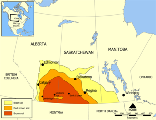
Palliser's Triangle, or the Palliser Triangle, is a semi-arid steppe occupying a substantial portion of the Western Canadian Prairie Provinces, Saskatchewan, Alberta and Manitoba, within the Great Plains region. While initially determined to be unsuitable for crops outside of the fertile belt due to arid conditions and dry climate, expansionists questioned this assessment, leading to homesteading in the Triangle. Agriculture in the region has since suffered from frequent droughts and other such hindrances.
The Dominion Land Survey is the method used to divide most of Western Canada into one-square-mile (2.6 km2) sections for agricultural and other purposes. It is based on the layout of the Public Land Survey System used in the United States, but has several differences. The DLS is the dominant survey method in the Prairie provinces, and it is also used in British Columbia along the Railway Belt, and in the Peace River Block in the northeast of the province.
Assiniboia District refers to two historical districts of Canada's Northwest Territories. The name is taken from the Assiniboine First Nation.
The Manitoba Act, 1870 is an act of the Parliament of Canada, and part of the Constitution of Canada, that provided for the admission of Manitoba as the fifth province of Canada.
Treaty Five is a treaty between Queen Victoria and Saulteaux and Swampy Cree non-treaty band governments and peoples around Lake Winnipeg in the District of Keewatin. Much of what is today central and northern Manitoba was covered by the treaty, as were a few small adjoining portions of the present-day provinces of Saskatchewan and Ontario.
The Great Sioux Reservation initially set aside land west of the Missouri River in South Dakota and Nebraska for the use of the Lakota Sioux, who had dominated this territory. The reservation was established in the Fort Laramie Treaty of 1868. It included all of present-day western South Dakota and modern Boyd County, Nebraska. This area was established by the United States as a reservation for the Teton Sioux, also known as the Lakota: the seven western bands of the "Seven Council Fires".
The Numbered Treaties are a series of eleven treaties signed between the First Nations, one of three groups of Indigenous Peoples in Canada, and the reigning monarch of Canada from 1871 to 1921. These agreements were created to allow the Government of Canada to pursue settlement and resource extraction in the affected regions, which include modern-day Alberta, British Columbia, Manitoba, Ontario, Saskatchewan, and the Northwest Territories. These treaties expanded the Dominion of Canada with large tracts of land in exchange for promises made to the indigenous people of the area. These terms were dependent on individual negotiations and so specific terms differed with each treaty.
St Catharines Milling and Lumber Co v R was the leading case on Aboriginal title in Canada for more than 80 years. The Judicial Committee of the Privy Council, affirming a ruling by the Supreme Court of Canada, held that Aboriginal title over land was allowed only at the Crown's pleasure and could be taken away at any time. The case, involving Ojibway Treaty No. 3, which had never been previously litigated before any court, is a leading decision in Canada on the differences between the division of legislative powers and property rights under the Constitution of Canada.
The Peace River Block is an 3,500,000-acre (14,000 km2) area of land located in northeastern British Columbia, in the Peace River Country. In exchange for building a rail line across Canada to British Columbia, the Canadian Pacific Railway was given the Railway Belt, 20 miles (32 km) of land on each side of the rail. To compensate the CPR for alienated or non-arable land in the 40-mile (64 km) wide strip, the Province allowed the Government of Canada to take control of 3,500,000 acres (14,000 km2) within B.C., northeast of the Rocky Mountains. This arrangement passed the provincial legislature on December 19, 1883, and passed the House of Commons of Canada on March 21, 1884, as the Settlement Act. As all the land northeast of the Rocky Mountains became a provincial reserve pending the Government of Canada's decision on what land to select prevented homesteading and land claims. After several surveys of the land the government took possession in 1907. The land, the government chose was an approximately square-shaped block of land 72.4 miles (116.5 km) north-south and 75.7 miles (121.8 km) east-west. The south boundary begins at the intersection of the Alberta-British Columbia border and the Twentieth Baseline of the Dominion Land Survey and the north boundary begins at the Twenty-third Baseline, however both boundaries are run at right angles to the Alberta-British Columbia Border without accounting for meridian convergence and thus deviate south of each baseline. Land within the block was initially surveyed using the 3rd and 4th Systems of the Dominion Land Survey, however much of the south and west parts of the block were eventually surveyed into district lots similar to other parts of British Columbia.
Post-Confederation Canada (1867–1914) is history of Canada from the formation of the Dominion to the outbreak of World War I in 1914. Canada had a population of 3.5 million, residing in the large expanse from Cape Breton to just beyond the Great Lakes, usually within a hundred miles or so of the Canada–United States border. One in three Canadians was French, and about 100,000 were aboriginal. It was a rural country composed of small farms. With a population of 115,000, Montreal was the largest city, followed by Toronto and Quebec at about 60,000. Pigs roamed the muddy streets of Ottawa, the small new national capital.
The Council of Keewatin was an unelected legislative body and territorial government for the now defunct District of Keewatin in Canada. The District of Keewatin was created by the passage of the Keewatin Act on October 7, 1876 from a portion of Canada's North West Territories. Lieutenant Governor Alexander Morris convinced the government that the new territorial government of the North West Territories would be unable to effectively administer land to the north and east of Manitoba. Shortly after the District of Keewatin was formed a large group of Icelanders arrived, infected with smallpox which quickly spread to the indigenous First Nation population. The Government of Canada allowed the Council to be formed for the purpose of containing the smallpox epidemic. The Council also administered Indian treaty claims, immigrant land claims, Hudson's Bay Company trading post concerns as well as policing and health care. The Council lasted from November 25, 1876, until April 16, 1877, after which control of the territory was returned under federal authority.
History of Saskatchewan encompasses the study of past human events and activities of the Canadian province of Saskatchewan, the middle of Canada's three prairie provinces. Archaeological studies give some clues as to the history and lifestyles of the Palaeo-Indian, Taltheilei, and Shield Archaic traditions who were the first occupants of the prehistoric era of this geographical area. They evolved into the history of the first nations people who kept their history alive in oral tradition. The First Nation bands that were a part of this area were the Chipewyan, Cree, Saulteaux, Assiniboine, Atsina, and Sioux.
The Natural Resources Acts were a series of Acts passed by the Parliament of Canada and the provinces of Alberta, British Columbia, Manitoba and Saskatchewan in 1930 to transfer control over crown lands and natural resources within these provinces from the Government of Canada to the provincial governments. Alberta, Manitoba and Saskatchewan had not been given control over their natural resources when they entered Confederation, unlike the other Canadian provinces. British Columbia had surrendered certain portions of its natural resources and Crown lands to the federal government, the Railway Belt and the Peace River Block, when it entered Confederation in 1871, as part of the agreement for the building of the transcontinental railway.
Land ownership in Canada is held by governments, Indigenous groups, corporations, and individuals. Canada is the second-largest country in the world by area; at 9,093,507 km2 or 3,511,085 mi2 of land. It occupies more than 6% of the Earth's surface.
The Railway Belt was a region in the Canadian Province of British Columbia, following the main line of the Canadian Pacific Railway. It extended approximately 20 miles on either side of the railway. Although the land was initially under provincial control, the Government of British Columbia agreed to transfer control of the Railway Belt to the Government of Canada, as a condition of the British Columbia Terms of Entry into Confederation. The federal Government then used the Railway Belt to further the building of the transcontinental railway, by granting portions of it to the CPR. The federal government also surveyed the Railway Belt under the Dominion Lands Survey.
In the 16th century Samuel de Champlain and Gabriel Sagard recorded that the Iroquois and Huron cultivated the soil for maize or "Indian corn". Maize, potatoes, beans (phaseolus), squash (Cucurbita) and the sunflower were grown throughout agricultural lands in North America by the 16th century. As early as 2300 BC evidence of squash was introduced to the northeastern woodlands region. Archaeological findings from 500 AD have shown corn cultivation in southern Ontario.
William Pearce (1848–1930), was a surveyor, statistician, planner, and administrator in western Canada. He served in the federal government from 1874 to 1904 as federal surveyor and administrator, as federal advisor for western development and as Western consultant for the Canadian Pacific Railway Company. As Inspector of Dominion Lands Agencies, he oversaw the "development and allocation of all land, forests, mineral and water resources" from "Winnipeg to the eastern foothills of the Rockies"—representing 400,000 square miles of land, earning his nickname—"Czar of the West". He was known for his work on the Bow River watershed irrigation systems that transformed lands in southern Alberta into fertile land.
The Porcupine Provincial Forest is a protected boreal forest in Canada which covers the Porcupine Hills on the border of Saskatchewan and Manitoba.
Imperial Plots: Women, Land, and the Spadework of British Colonialism on the Canadian Prairies is a 2016 book by Sarah Carter, professor of history at the University of Alberta. The book documents the history of female homesteaders on the Canadian Prairies and the relationship between that history and Canadian colonialism.
This page is based on this Wikipedia article Text is available under the CC BY-SA 4.0 license; additional terms may apply. Images, videos and audio are available under their respective licenses.