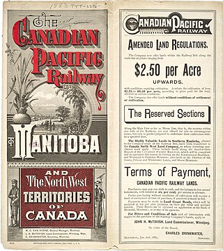
"Last Best West" was a phrase used to market the Canadian prairies to prospective immigrants. The phrase was used to advertise the Canadian west abroad, and in Eastern Canada, during the heyday of western settlement from 1896 until the start of the First World War in 1914, when few could leave Europe.[1]
One of the key considerations for the government in this recruitment of settlers was the fear that Americans would stream North and settle the southern parts of what would become the provinces of Alberta and Saskatchewan. The goal was to encourage families, and therefore make it hospitable for women who could edify and purify the frontier.[2]
The program was so successful that little more than nine years later the provinces of Alberta and Saskatchewan were formed out of the enormous North-West Territories of Canada.
Printed on pamphlets distributed in Northern Europe, Britain and the United States, the campaign was operated by the Minister of the Interior Clifford Sifton, appointed by Prime Minister Wilfrid Laurier to oversee settlement of the west. "The Last Best West" was a direct comparison to the United States.[3] While there were still tracts of land available in the U.S., most of the best land had been taken and the American frontier had been declared closed in 1890. The land in Canada was the last region still not populated by Europeans.
The phrase was for the most part a marketing ploy. However, even though the frost-free season is shorter in Canada, a less arid climate compensates for this and the Canadian prairies have long been more productive than those of the Dakotas and Wyoming. In addition, unlike the American West, the settlement of the Canadian west was well organized, with the North-West Mounted Police providing law and order.
Canada sought immigrants from Europe, especially farmers; cartoon by John Wilson Bengough from Toronto Globe 19 May 1898
Notes
↑ Jean Bruce, The last best West (Fitzhenry & Whiteside, 1976)
↑ Cecily Devereux, "'And let them wash me from this clanging world': Hugh and Ion, 'The Last Best West' and Purity Discourse in 1885." Journal of Canadian Studies 32.2 (1997) pp: 100+
↑ Paul F. Sharp, "The American Farmer and the" Last Best West"." Agricultural History 21#2 (1947): 65-75 in JSTOR.
Alberta is one of the thirteen provinces and territories of Canada. It is a part of Western Canada and is one of the three prairie provinces. Alberta borders British Columbia to the west, Saskatchewan to the east, the Northwest Territories to the north, and the U.S. state of Montana to the south. It is one of the only two landlocked provinces in Canada, with Saskatchewan being the other. The eastern part of the province is occupied by the Great Plains, while the western part borders the Rocky Mountains. The province has a predominantly continental climate but experiences quick temperature changes due to air aridity. Seasonal temperature swings are less pronounced in western Alberta due to occasional Chinook winds.
Saskatchewan is a province in Western Canada, bordered on the west by Alberta, on the north by the Northwest Territories, on the east by Manitoba, to the northeast by Nunavut, and to the south by the United States. Saskatchewan and Alberta are the only landlocked provinces of Canada. In 2024, Saskatchewan's population was estimated at 1,231,043. Nearly 10% of Saskatchewan's total area of 651,900 km2 (251,700 sq mi) is fresh water, mostly rivers, reservoirs, and lakes.
A frontier is a political and geographical term referring to areas near or beyond a boundary.
Russian Germans in North America are descended from the many ethnic Germans from Russia who emigrated to North America.
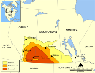
Palliser's Triangle, or the Palliser Triangle, is a semi-arid steppe occupying a substantial portion of the Western Canadian Canadian Prairies, Saskatchewan, Alberta and Manitoba, within the Great Plains region. While initially determined to be unsuitable for crops outside of the fertile belt due to arid conditions and dry climate, expansionists questioned this assessment, leading to homesteading in the Triangle. Agriculture in the region has since suffered from frequent droughts and other such hindrances.
The Dominion Land Survey is the method used to divide most of Western Canada into one-square-mile (2.6 km2) sections for agricultural and other purposes. It is based on the layout of the Public Land Survey System used in the United States, but has several differences. The DLS is the dominant survey method in the Prairie provinces, and it is also used in British Columbia along the Railway Belt, and in the Peace River Block in the northeast of the province.
The Dominion Lands Act was an 1872 Canadian law that aimed to encourage the settlement of the Canadian Prairies and to help prevent the area being claimed by the United States. The Act was closely based on the U.S. Homestead Act of 1862, setting conditions in which the western lands could be settled and their natural resources developed.
The Canadian Prairies is a region in Western Canada. It includes the Canadian portion of the Great Plains and the Prairie provinces, namely Alberta, Saskatchewan, and Manitoba. These provinces are partially covered by grasslands, plains, and lowlands, mostly in the southern regions. The northernmost reaches of the Canadian Prairies are less dense in population, marked by forests and more variable topography. If the region is defined to include areas only covered by prairie land, the corresponding region is known as the Interior Plains. Physical or ecological aspects of the Canadian Prairies extend to northeastern British Columbia, but that area is not included in political use of the term.
Canadian historians until the 1960s tended to focus on the history of Canada's economy because of the far fewer political, economic, religious and military conflicts present in Canadian history than in other societies. Many of the most prominent English Canadian historians from this period were economic historians, such as Harold Innis, Donald Creighton and Arthur R. M. Lower.
Ukrainian Canadians are Canadian citizens of Ukrainian descent or Ukrainian-born people who immigrated to Canada.
The Métis are an Indigenous people whose historical homelands include Canada's three Prairie Provinces. They have a shared history and culture, deriving from specific mixed European and Indigenous ancestry, which became distinct through ethnogenesis by the mid-18th century, during the early years of the North American fur trade.
The province of Alberta, Canada, has a history and prehistory stretching back thousands of years. The ancestors of today's First Nations in Alberta arrived in the area by at least 10,000 BC according to the Bering land bridge theory. Southerly tribes, the Plain Indians, such as the Blackfoot, Blood, and Peigans eventually adapted to seminomadic plains bison hunting, originally without the aid of horses, but later with horses that Europeans had introduced.
A block settlement is a particular type of land distribution which allows settlers with the same ethnicity to form small colonies. This settlement type was used throughout western Canada between the late 19th and early 20th centuries. Some were planned and others were spontaneously created by the settlers themselves. As a legacy of the block settlements, the three Prairie Provinces have several regions where ancestries other than British are the largest, unlike the norm in surrounding regions.
Post-Confederation Canada (1867–1914) is history of Canada from the formation of the Dominion to the outbreak of World War I in 1914. Canada had a population of 3.5 million, residing in the large expanse from Cape Breton to just beyond the Great Lakes, usually within a hundred miles or so of the Canada–United States border. One in three Canadians was French, and about 100,000 were aboriginal. It was a rural country composed of small farms. With a population of 115,000, Montreal was the largest city, followed by Toronto and Quebec at about 60,000. Pigs roamed the muddy streets of Ottawa, the small new national capital.
The history of immigration to Canada details the movement of people to modern-day Canada. The modern Canadian legal regime was founded in 1867, but Canada also has legal and cultural continuity with French and British colonies in North America that go back to the 17th century, and during the colonial era, immigration was a major political and economic issue with Britain and France competing to fill their colonies with loyal settlers. Until then, the land that now makes up Canada was inhabited by many distinct Indigenous peoples for thousands of years. Indigenous peoples contributed significantly to the culture and economy of the early European colonies to which was added several waves of European immigration. More recently, the source of migrants to Canada has shifted away from Europe and towards Asia and Africa. Canada's cultural identity has evolved constantly in tandem with changes in immigration patterns.
History of Saskatchewan encompasses the study of past human events and activities of the Canadian province of Saskatchewan, the middle of Canada's three prairie provinces. Archaeological studies give some clues as to the history and lifestyles of the Palaeo-Indian, Taltheilei, and Shield Archaic traditions who were the first occupants of the prehistoric era of this geographical area. They evolved into the history of the First Nations people who kept their history alive in oral tradition. The First Nation bands that were a part of this area were the Chipewyan, Cree, Saulteaux, Assiniboine, Atsina, and Sioux.
Land is owned in Canada by governments, Indigenous groups, corporations, and individuals. Canada is the second-largest country in the world by area; at 9,093,507 km2 or 3,511,085 mi2 of land. It occupies more than 6% of the Earth's surface.
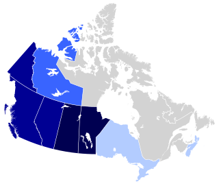
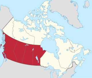
Western Canada, also referred to as the Western provinces, Canadian West or the Western provinces of Canada, and commonly known within Canada as the West, is a Canadian region that includes the four western provinces just north of the Canada–United States border namely British Columbia, Alberta, Saskatchewan and Manitoba. The people of the region are often referred to as "Western Canadians" or "Westerners", and though diverse from province to province are largely seen as being collectively distinct from other Canadians along cultural, linguistic, socioeconomic, geographic and political lines. They account for approximately 32% of Canada's total population.
New Finland or Uusi Suomi is a district in the Qu'Appelle valley, the south eastern part of the province of Saskatchewan, Canada.
Interprovincial migration in Canada is the movement by people from one Canadian province or territory to another with the intention of settling, permanently or temporarily, in the new province or territory; it is more-or-less stable over time. In fiscal year 2019–20, 278,316 Canadians migrated province, representing 0.729% of the population.
This page is based on this Wikipedia article Text is available under the CC BY-SA 4.0 license; additional terms may apply. Images, videos and audio are available under their respective licenses.