This article has multiple issues. Please help improve it or discuss these issues on the talk page . (Learn how and when to remove these template messages)
|
West Vancouver | |
---|---|
District municipality | |
The Corporation of the District of West Vancouver [1] | |
Nickname: West Van | |
Motto(s): "Consilio et animis" (English: "By wisdom and courage") | |
Coordinates: 49°22′0″N123°10′0″W / 49.36667°N 123.16667°W | |
Country | Canada |
Province | British Columbia |
Regional district | Metro Vancouver |
Incorporated | March 15, 1912 |
Government | |
• Type | Mayor-council government |
• Body | West Vancouver Council |
• Mayor | Mark Sager |
• Council | List of councillors |
• MLA | |
• MP | Patrick Weiler (Lib.) |
Area | |
• Land | 87.18 km2 (33.66 sq mi) |
Highest elevation [4] (Mt Strachan) | 1,440 m (4,720 ft) |
Lowest elevation | 0 m (0 ft) |
Population (2021) [3] | |
• Total | 44,122 |
• Estimate (2022) [5] | 45,406 |
• Density | 506.1/km2 (1,311/sq mi) |
Demonym | West Vancouverite |
Time zone | UTC−08:00 (PST) |
• Summer (DST) | UTC−07:00 (PDT) |
Forward sortation area | |
Area codes | 604, 778, 236, 672 |
Website | westvancouver |
West Vancouver is a district municipality in the province of British Columbia, Canada. A member municipality of the Metro Vancouver Regional District, West Vancouver is to the northwest of the city of Vancouver on the northern side of English Bay and the southeast shore of Howe Sound, and is adjoined by the District of North Vancouver to its east. Together with the District of North Vancouver and the City of North Vancouver, it is part of a local regional grouping referred to as the North Shore municipalities, or simply "the North Shore".
West Vancouver is connected to the downtown city of Vancouver via the Lions Gate Bridge. Originally named First Narrows Bridge, its completion in 1938 allowed the people of the North Shore municipalities to cross 1,823 metres (5,981 ft) of the Burrard Inlet to the city. [6]
West Vancouver had a population of 44,122 at the 2021 Canadian census. [3] Cypress Provincial Park, mostly located within the municipal boundaries, was one of the venues for the 2010 Winter Olympics. West Vancouver is also home of Canada's first shopping mall, Park Royal Shopping Centre, [7] and also the Horseshoe Bay ferry terminal, one of the main connecting hubs between the British Columbia mainland and Vancouver Island.
The Municipality of West Vancouver was incorporated on March 15, 1912, after separating from the District of North Vancouver. [8] The first municipal election was held on April 6, 1912. In November 1938, the Lions Gate Bridge was opened to traffic, allowing extensive growth of the semi-populated community, previously only accessible by ferry. Some homes in West Vancouver date back to the 1920s and 30s, though most of the currently existing dwellings were built in the 1970s and 80s, and mostly in British Pacific Properties' developments.[ citation needed ]
West Vancouver was the second municipality in British Columbia to record cases of COVID-19 in March 2020, following the first reported outbreak at Lynn Valley Care Home in the neighbouring District of North Vancouver. [13] On March 12, 2020, long-term care facility Hollyburn House announced they had identified two positive cases among a staff member and resident. [14]
Mayor Mary-Ann Booth began instituting closures on March 13, and on March 16 closed all facilities run by the District except for Municipal Hall, police and fire services, the District Operations Centre and Capilano View Cemetery. [15] She declared a local state of emergency on March 21, granting the municipal government additional powers to enforce orders issued by provincial health officer Bonnie Henry, including business closures and revocation of business licenses. [16]
West Vancouver is mainly a residential district as many residents are retired, work at home, or take the short commute to downtown Vancouver.
A 13-block strip of Marine Drive serves as a commercial district, featuring shops, small offices, garages and gas stations, restaurants, banks, and other common amenities. The area between 13th and 19th Streets is commonly known as Ambleside Village, and the area between 24th and 26th Streets is known as the village of Dundarave. This commercial area is served by the Ambleside Dundarave Business Improvement Association.
West Vancouver is also home to Park Royal Shopping Centre, Canada's first mall. Opened in the 1950s, it now consumes 2 kilometres (1.2 mi) of both sides of Marine Drive near North Vancouver. Park Royal is the second largest mall in British Columbia, after Metropolis at Metrotown in Burnaby. Located nearby is a major bus terminal for Blue Bus and North Vancouver TransLink buses.
The West Vancouver Memorial Library, located in Ambleside, has a circulation rate of 21.32 per capita, the highest circulation rate per capita in Canada. [17]
At the 2021 Canadian census conducted by Statistics Canada, West Vancouver had a population of 44,122 living in 17,690 of its 18,795 total private dwellings, a change of 3.9% from its 2016 population of 42,473. With a land area of 87.18 km2 (33.66 sq mi), it had a population density of 506.1/km2 (1,310.8/sq mi) in 2021. [3]
West Vancouver has the second highest percentage of persons aged 65 or older in BC with 22% of persons fitting into the category, compared with 13% for the rest of the province. The top five professions in West Vancouver are professional science and technical services; retail trade; health care; finance and insurance; and educational services. A large portion of the population is involved in senior management in comparison with the rest of the province. [18]
Panethnic group | 2021 [19] | 2016 [20] | 2011 [21] | 2006 [22] | 2001 [23] | |||||
---|---|---|---|---|---|---|---|---|---|---|
Pop. | % | Pop. | % | Pop. | % | Pop. | % | Pop. | % | |
European [lower-alpha 1] | 24,195 | 55.77% | 26,285 | 63.06% | 29,910 | 71.14% | 31,960 | 76.78% | 32,475 | 79.48% |
East Asian [lower-alpha 2] | 9,990 | 23.03% | 8,970 | 21.52% | 5,870 | 13.96% | 5,025 | 12.07% | 4,755 | 11.64% |
Middle Eastern [lower-alpha 3] | 5,310 | 12.24% | 3,915 | 9.39% | 3,445 | 8.19% | 2,480 | 5.96% | 2,055 | 5.03% |
South Asian | 1,405 | 3.24% | 975 | 2.34% | 1,040 | 2.47% | 950 | 2.28% | 835 | 2.04% |
Southeast Asian [lower-alpha 4] | 770 | 1.77% | 660 | 1.58% | 780 | 1.86% | 490 | 1.18% | 335 | 0.82% |
Indigenous | 425 | 0.98% | 240 | 0.58% | 265 | 0.63% | 155 | 0.37% | 100 | 0.24% |
Latin American | 430 | 0.99% | 240 | 0.58% | 185 | 0.44% | 255 | 0.61% | 135 | 0.33% |
African | 185 | 0.43% | 90 | 0.22% | 185 | 0.44% | 125 | 0.3% | 80 | 0.2% |
Other [lower-alpha 5] | 670 | 1.54% | 310 | 0.74% | 365 | 0.87% | 170 | 0.41% | 100 | 0.24% |
Total responses | 43,385 | 98.33% | 41,680 | 98.13% | 42,045 | 98.48% | 41,625 | 98.8% | 40,860 | 98.65% |
Total population [lower-alpha 6] | 44,122 | 100% | 42,473 | 100% | 42,694 | 100% | 42,131 | 100% | 41,421 | 100% |
According to the 2021 census, religious groups in West Vancouver included: [19]
Mother language | Population | % of total population | % of non-official language population | |
---|---|---|---|---|
English | 28,280 | 67.1 | N/A | |
Persian | 3,400 | 8.1 | 25.7 | |
Chinese | n.o.s. | 1,415 | 3.4 | 10.7 |
Mandarin | 1,335 | 3.2 | 10.1 | |
Total | 2750 | 6.6 | 20.8 | |
German | 1,015 | 2.4 | 7.7 | |
Korean | 915 | 2.2 | 6.9 | |
French | 545 | 1.3 | N/A |
As of the 2006 census, the languages spoken in West Vancouver were:
By mother tongue:
By most commonly used household language:
West Vancouver is Canada's wealthiest municipality, with an average household net worth of CA$4,454,424. [25] North Vancouver just next door is the tenth richest. West Vancouver is home to some very large, luxurious and expensive properties and houses. Occasionally, houses have been priced and sold at around $30,000,000. In 2011, West Vancouver's average house sold for over $2,000,000; [26] 95% of the houses or close to 16,000 homes are worth over $1 million. In West Vancouver, average total incomes were $86,253 for males and $48,070 for females, almost double the provincial average. Over 80% of the population has a total family income of at least $100,000. [18]
West Vancouver is served by West Vancouver Municipal Transit, colloquially known as Blue Bus. West Vancouver Municipal Transit is one of two bus companies in the Greater Vancouver region operating under contract for TransLink. Transfer is free between West Vancouver Municipal Transit buses and other TransLink buses.
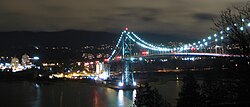
The only freeway route within municipal limits is British Columbia Highway 1 (part of the Trans-Canada Highway), which begins in the community of Horseshoe Bay and continues east into the District of North Vancouver. Highway 99 also runs through West Vancouver, sharing the freeway alignment with Highway 1 between Horseshoe Bay and Taylor Way, and connects the municipality with Downtown Vancouver (via the Lions Gate Bridge) and Whistler (via the Sea-to-Sky Corridor).
Additionally, BC Ferries operates routes departing from Horseshoe Bay to Nanaimo, Bowen Island, and the Sunshine Coast.
West Vancouver is known for its parks such as Cypress Provincial Park, which offers scenic views of Howe Sound and the Metro Vancouver area. Whytecliff Park and Lighthouse Park, near the community of Horseshoe Bay, at the continental terminus of the Trans-Canada Highway. All of West Vancouver is situated on the side of the Coast Mountains. Because of this position, many homes in West Vancouver have views of Vancouver Island, the Lower Mainland, and/or Howe Sound.
Ambleside Park and the 15-block-long West Vancouver Seawall are popular spots for families and outdoor enthusiasts. Whytecliff Park is regarded as one of the best scuba diving spots in Western Canada. The District also has many other small parks, as well as Lighthouse Park at Point Atkinson, which contains some old-growth forest and has with views of Vancouver from downtown to Point Grey and is the boundary-point between English Bay and the Strait of Georgia. John Lawson Park is also another popular area for families, it features a playground for children, an open grass field for families to picnic, and a view of Lions Gate Bridge and the downtown skyline which are both across the water.
West Vancouver has several public recreation facilities including an 18-hole par 3 golf course, a pool, an ice rink, basketball and tennis courts, skate parks and numerous public parks. The new West Vancouver Community Centre (or WVCC) has been rebuilt and opened Spring 2009. Cypress Provincial Park also has mountain biking trails and a large ski and snowboard resort, which served as one of the venues for the 2010 Winter Olympics.
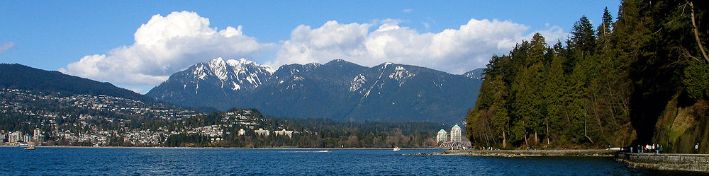
As of 2022, the mayor is Mark Sager, who previously served as West Van Mayor from 1991–1996.
West Vancouver ridings typically include Squamish and Whistler, and sometimes the Sunshine Coast.
Provincially, Joan McIntyre and Ralph Sultan of the BC Liberal Party were elected to the West Vancouver-Sea To Sky and West Vancouver-Capilano ridings, respectively, in the 2005 Provincial election (West Vancouver-Sea To Sky Country includes Squamish, Whistler and Pemberton).
Federally, West Vancouver-based ridings historically have voted Conservative since 1974, electing John Reynolds of the Reform Party of Canada (later the Canadian Alliance) from 1997 to 2004. Reynolds declined to run for re-election in 2006, however, and Liberal Blair Wilson defeated Conservative John Weston to replace Reynolds as Member of Parliament from the West Vancouver—Sunshine Coast—Sea to Sky Country electoral district. Wilson left the Liberals in 2007 and joined the Green Party in 2008, becoming the first Green Member of Parliament. The re-election in 2008 saw a rematch between Weston and Wilson. This time Weston emerged as the victor, carrying nearly triple the vote of his incumbent opponent to handily return the riding to the Conservatives. Weston won again in 2011. In the 2015 federal election, Weston was unseated by Liberal candidate Pam Goldsmith-Jones, who was previously the mayor of West Vancouver from 2005 to 2011. Pamela Goldsmith-Jones chose not to run for re-election in the 2019 federal election and Patrick Weiler of the Liberal Party of Canada went on to win the election.
There are 17 public schools that make up School District 45 West Vancouver. There are also 4 private schools in the city. Of these 21 schools, 6 are high schools. Over 80 percent of West Vancouver high school graduates go to post-secondary schools. [27] Many residents from Squamish, the Sunshine Coast, and North Vancouver attend West Vancouver schools.
The Lower Mainland is a geographic and cultural region of the mainland coast of British Columbia that generally comprises the regional districts of Metro Vancouver and the Fraser Valley. Home to approximately 3.05 million people as of the 2021 Canadian census, the Lower Mainland contains sixteen of the province's 30 most populous municipalities and approximately 60% of the province's total population.
Burnaby is a city in the Lower Mainland region of British Columbia, Canada. Located in the centre of the Burrard Peninsula, it neighbours the City of Vancouver to the west, the District of North Vancouver across the confluence of the Burrard Inlet with its Indian Arm to the north, Port Moody and Coquitlam to the east, New Westminster and Surrey across the Fraser River to the southeast, and Richmond on the Lulu Island to the southwest.
Bowen Island, British Columbia, is an island municipality that is part of Metro Vancouver, and within the jurisdiction of the Islands Trust. Located in Howe Sound, it is approximately 6 kilometres (3.7 mi) wide by 12 kilometres (7.5 mi) long, and at its closest point is about 3 kilometres (1.9 mi) west of the mainland. There is regular ferry service from Horseshoe Bay provided by BC Ferries, and semi-regular water taxi services. The population of 4,256 is supplemented in the summer by about 1,500 visitors. It has a land area of 50.12 km2 (19.35 sq mi).
Port Coquitlam is a city in British Columbia, Canada. It is one of 21 municipalities comprising Metro Vancouver. Located 27 km (17 mi) east of Vancouver, it is on the north bank of the confluence of the Fraser River and the Pitt River. Coquitlam borders it to the north and west. Pitt Meadows lies across the Pitt River from it. Port Coquitlam is bisected by Lougheed Highway and the Canadian Pacific Kansas City railway. Port Coquitlam is often referred to as "PoCo". It is Canada's 93rd-largest municipality by population.
The Capital Regional District (CRD) is a local government administrative district encompassing the southern tip of Vancouver Island and the southern Gulf Islands in the Canadian province of British Columbia. The CRD is one of several regional districts in British Columbia and had an official population of 415,451 as of the Canada 2021 Census.
The City of North Vancouver is a city on the north shore of Burrard Inlet, British Columbia, Canada. It is a suburb of Vancouver. It is the smallest in area and the most urbanized of the North Shore municipalities, although it has significant industry of its own – including shipping, chemical production, and film production. The city is served by the Royal Canadian Mounted Police, British Columbia Ambulance Service, and the North Vancouver City Fire Department.
View Royal is a town in Greater Victoria and a member municipality of the Capital Regional District of British Columbia, Canada. View Royal has a population of 11,575 residents. With over 700 hectares of parkland, View Royal includes Thetis, McKenzie, Pike, and Prior Lakes and portions of Esquimalt Harbour and Portage Inlet.
Golden is a town in southeastern British Columbia, Canada, 262 kilometres (163 mi) west of Calgary, Alberta, and 713 kilometres (443 mi) east of Vancouver.
The District of North Vancouver is a district municipality in British Columbia, Canada, and is part of Metro Vancouver. It surrounds the City of North Vancouver on three sides. It is largely characterized as a relatively quiet, affluent suburban hub home to many middle and upper-middle-class families. Homes in the District of North Vancouver generally range from mid-sized family bungalows to very large luxury houses. A number of dense multi-family and mixed-use developments have popped up across the district in recent years; however, the district remains a primarily suburban municipality. It is served by the Royal Canadian Mounted Police, British Columbia Ambulance Service, and the District of North Vancouver Fire Department.
Duncan is a city on southern Vancouver Island in British Columbia, Canada. It is the smallest city by area in Canada. It was incorporated in 1912.
Greater Vancouver, also known as Metro Vancouver, is the metropolitan area with its major urban centre being the city of Vancouver, British Columbia, Canada. The term "Greater Vancouver" describes an area that is roughly coterminous with the region governed by the Metro Vancouver Regional District (MVRD), though it predates the 1966 creation of the regional district. It is often used to include areas beyond the boundaries of the regional district but does not generally include wilderness and agricultural areas that are included within the MVRD.
Peachland is a district municipality in the Okanagan Valley on the west side of Okanagan Lake in British Columbia, Canada. It was founded in 1899 by John Moore Robinson, although the region had long been home to the Okanagan people. Peachland is approximately half-an-hour's drive south of the city of Kelowna and about a 20-minute drive north of Summerland. The Okanagan Valley is very narrow in the area and there are few terraces that mark former lake levels and the former lake bottom. As a result, the city is largely located on a steep sidehill. Like many other areas in the Okanagan, Peachland is rapidly growing, with new residents coming from all across Canada. Across the lake from Peachland is Rattlesnake Island, home of the legendary Ogopogo. Peachland is approximately 370 km from Vancouver, British Columbia, on the British Columbia south coast.
The Sunshine Coast Regional District is a regional district in British Columbia, Canada. It is located on the southern mainland coast, across Georgia Strait from Vancouver Island. It borders on the qathet Regional District to the north, the Squamish-Lillooet Regional District to the east, and, across Howe Sound, the Metro Vancouver District to the south. The regional district offices are located in the District Municipality of Sechelt.
North Cowichan is a district municipality established in 1873 on Vancouver Island, in British Columbia, Canada. The municipality is part of the Cowichan Valley Regional District. North Cowichan is noted for a landscape including forests, beaches, rivers, and lakes. The municipality encompasses the communities of Chemainus; Westholme; Crofton; Maple Bay; and "the South End". The latter is an informal name for a built-up area which is essentially a suburb of the City of Duncan, a separate municipality.
Sechelt is a district municipality located on the lower Sunshine Coast of British Columbia. Approximately 50 km northwest of Vancouver, it is accessible from mainland British Columbia by a 40-minute ferry trip between Horseshoe Bay and Langdale, and a 25-minute drive from Langdale along Highway 101, also known as the Sunshine Coast Highway. The name Sechelt is derived from the she shashishalhem word shíshálh, the name of the First Nations people who first settled the area thousands of years ago.
Lake Country is a district municipality with a population of approximately 15,000 in the Okanagan Valley region of British Columbia, Canada. It is a part of the Central Okanagan Regional District, and of the Kelowna metropolitan area. The city of Kelowna lies to the south, while the city of Vernon lies to the north. As its name suggests, there are a number of lakes in the vicinity of Lake Country, and outside the municipal boundaries in the hills to the east. Okanagan Lake defines the western boundary of the municipality, while the entirety of Wood Lake and the southernmost portion of Kalamalka Lake are encompassed by it.
Port Hardy is a district municipality in British Columbia, Canada located on the north-east tip of Vancouver Island. Port Hardy has a population of 3,902 as of the 2021 census.
The demographics of Metro Vancouver indicate a multicultural and multiracial region. Metro Vancouver is a metropolitan area, with its major urban centre being Vancouver, British Columbia, Canada. The Vancouver census metropolitan area, as defined by Statistics Canada, encompasses roughly the same territory as the Metro Vancouver Regional District, a regional district in British Columbia. The regional district includes 23 local authorities. Figures provided here are for the Vancouver census metropolitan area and not for the City of Vancouver.
The District of Kent is a district municipality located 116 kilometres (72 mi) east of Vancouver, British Columbia. Part of the Fraser Valley Regional District, Kent consists of several communities, the largest and most well-known being Agassiz—the only town in the municipality—Harrison Mills, Kilby, Mount Woodside, Kent Prairie, Sea Bird Island and Ruby Creek. Included within the municipality's boundaries are several separately-governed Indian reserves, including the Seabird Island First Nation's reserves on and around the island of the same name.
Ambleside, West Vancouver, is a neighbourhood that occupies the southeastern corner of the community, with only Park Royal being farther east. The neighborhood is bordered by the neighbourhoods of Dundarave, Park Royal, and the British Properties. Ambleside overs the area from 19th Street to 13th Street, and from Fulton Avenue down to the waterfront. Marine Drive forms the centre of the community's commercial core, with two streets leading off from it.
{{cite web}}
: CS1 maint: unfit URL (link)