Stewart, British Columbia

Last updated

Stewart
District of Stewart [1]
Stewart BC.JPG
Canada British Columbia location map 2.svg
Red pog.svg
Stewart
Coordinates: 55°56′09″N129°59′27″W / 55.93583°N 129.99083°W / 55.93583; -129.99083
CountryCanada
Province British Columbia
Regional district Kitimat–Stikine
Incorporated1930
Government
   Mayor Angela Brand Danuser
Area
  Total552.08 km2 (213.16 sq mi)
Elevation
0 m (0 ft)
Population
 (2016)
  Total401
  Density0.73/km2 (1.9/sq mi)
Time zone UTC−8 (PST)
Postal Code 0098
V0T 1W0
Area code(s) 250, 778, 236
Highways BC-37A.svg Hwy 37A
Website districtofstewart.com OOjs UI icon edit-ltr-progressive.svg

Stewart is a district municipality at the head of the Portland Canal in northwestern British Columbia, Canada, [2] near the Alaskan panhandle. In 2021, it had a population of 517.

Contents

Salmon Glacier in British Columbia, a popular tourist destination. 2015-08-07 Salmon Glacier, BC, Canada 1016.jpg
Salmon Glacier in British Columbia, a popular tourist destination.

History

The Nisga'a, who live around the Nass River, called the head of Portland Canal Skam-A-Kounst, meaning "safe house" or "strong house", probably because it served them as a retreat from the harassment of the Haida and Tlingit from the outer coast. [2] [3] They travelled in the area seasonally to pick berries and hunt birds. It and the rest of the Portland Canal had previously been the domain of the Tsetsaut people, also called the Skam-a-Kounst Indians, or Jits'aawit in Nisga'a, an Athapaskan people who became decimated by war and disease and were driven out of the Stewart area by either Haida or Nisga'a in 1856–57.

The Portland Canal was first explored and named in July 1793 by Captain George Vancouver in honour of William Cavendish-Bentinck, 3rd Duke of Portland (1738–1808), Home Secretary from 1794 to 1801. Vancouver met two friendly native people at the current site of Stewart. [4] The area around the Portland Canal was again explored in 1896 by Captain D.D. Gaillard of the United States Army Corps of Engineers (after whom the Gaillard Cut in the Panama Canal was later named). Two years after Gaillard's visit, the first prospectors and settlers arrived. Among them was D. J. Raine, for whom a creek and a mountain in the area are named. The Stewart brothers arrived in 1902. In 1905, Robert M. Stewart, the first postmaster, named the town Stewart.

Gold and silver mining dominated the early economy. Nearby Hyder, Alaska, boomed with the discovery of rich silver veins in the upper Salmon River basin in 1917 and 1918. Hyder became an access and supply point for the mines, while Stewart served as the port for Canadian mining activity, which was centred on the town of Premier, which was accessed by a 14 miles (23 km) road from Hyder. Other mines in the area were the Jumbo, BC Silver, Red Cliff, and Porter-Idaho. More large camps were south of Stewart at Anyox and Maple Bay.

Disney's Eight Below , starring Paul Walker and Jason Biggs, was partially filmed here. The exterior shots from John Carpenter's science fiction classic The Thing were filmed within Salmon Glacier.

Fire hall in Stewart STEWART FIRE HOUSE, BRITISH COLUMBIA.jpg
Fire hall in Stewart

Demographics

In the 2021 Census of Population conducted by Statistics Canada, Stewart had a population of 517 living in 256 of its 337 total private dwellings, a change of

Transportation

Stewart is accessible by highway from the British Columbia highway system, via Highway 37A, by boat through the Portland Canal, or by air through Stewart Airport.

Location

Mt. Rainey is southeast of Stewart Mt. Rainey.jpg
Mt. Rainey is southeast of Stewart

West of Stewart is Hyder, Alaska, which is only 3 kilometres (2 mi) from the town. Northwest of Stewart, and accessible only by way of Hyder, is Premier, British Columbia, notable for being in Canada, but accessible only through a portion of the United States that is accessible only from Canada.

East of the town is Meziadin Junction, which is 61 kilometres (38 mi) from the town. Also east is Kitwanga, British Columbia, which is located 218 kilometres (135 mi) from the town, and Dease Lake, British Columbia, which is located 392 kilometres (244 mi) north of Stewart. It is the northernmost point on Canada's Pacific coast.

Climate

Stewart has a humid continental climate (Dfb), with about 1,866.8 mm (73.5 in) per year of precipitation, much of it as snow, and an average yearly temperature of 6.1 °C (43.0 °F), according to Environment Canada. [6] Stewart is Canada's most northerly ice-free port. [7] Due to its proximity to the ocean, the climate retains strong maritime influences, with winters being far milder than locations farther inland. With an average of 985 hours of annual sunshine, Stewart is one of the cloudiest places in the world.

Climate data for Stewart Airport
Climate ID: 1067742; coordinates 55°56′10″N129°59′06″W / 55.93611°N 129.98500°W / 55.93611; -129.98500 (Stewart Aerodrome) ; elevation: 7.3 m (24 ft); 1981–2010 normals, extremes 1910–present
MonthJanFebMarAprMayJunJulAugSepOctNovDecYear
Record high humidex 9.410.415.225.330.138.939.037.528.321.210.59.939.0
Record high °C (°F)13.3
(55.9)
11.7
(53.1)
17.1
(62.8)
25.5
(77.9)
31.7
(89.1)
35.0
(95.0)
33.4
(92.1)
32.7
(90.9)
30.6
(87.1)
20.6
(69.1)
14.4
(57.9)
11.2
(52.2)
35.0
(95.0)
Mean daily maximum °C (°F)−0.5
(31.1)
2.3
(36.1)
5.8
(42.4)
11.0
(51.8)
15.8
(60.4)
18.9
(66.0)
19.8
(67.6)
18.8
(65.8)
14.7
(58.5)
8.9
(48.0)
2.7
(36.9)
0.1
(32.2)
9.9
(49.8)
Daily mean °C (°F)−3.0
(26.6)
−1.1
(30.0)
1.9
(35.4)
6.1
(43.0)
10.7
(51.3)
13.9
(57.0)
15.1
(59.2)
14.3
(57.7)
11.1
(52.0)
6.3
(43.3)
0.6
(33.1)
−2.1
(28.2)
6.1
(43.0)
Mean daily minimum °C (°F)−5.5
(22.1)
−4.5
(23.9)
−2.0
(28.4)
1.1
(34.0)
5.5
(41.9)
8.9
(48.0)
10.4
(50.7)
9.8
(49.6)
7.4
(45.3)
3.6
(38.5)
−1.7
(28.9)
−4.3
(24.3)
2.4
(36.3)
Record low °C (°F)−30.0
(−22.0)
−28.3
(−18.9)
−23.3
(−9.9)
−13.9
(7.0)
−4.4
(24.1)
−2.8
(27.0)
0.0
(32.0)
−5.0
(23.0)
−3.9
(25.0)
−12.8
(9.0)
−24.8
(−12.6)
−26.1
(−15.0)
−30.0
(−22.0)
Record low wind chill −30.1−29.2−25.7−12.2−1.30.00.00.0−2.7−13.0−36.7−32.5−36.7
Average precipitation mm (inches)238.0
(9.37)
137.0
(5.39)
121.8
(4.80)
89.1
(3.51)
72.3
(2.85)
65.6
(2.58)
73.0
(2.87)
122.4
(4.82)
217.3
(8.56)
278.0
(10.94)
230.1
(9.06)
222.2
(8.75)
1,866.8
(73.50)
Average rainfall mm (inches)88.1
(3.47)
57.6
(2.27)
85.6
(3.37)
73.4
(2.89)
71.8
(2.83)
65.6
(2.58)
73.0
(2.87)
122.4
(4.82)
217.3
(8.56)
268.3
(10.56)
123.9
(4.88)
91.9
(3.62)
1,338.9
(52.71)
Average snowfall cm (inches)162.8
(64.1)
85.6
(33.7)
38.8
(15.3)
15.8
(6.2)
0.5
(0.2)
0.0
(0.0)
0.0
(0.0)
0.1
(0.0)
0.0
(0.0)
9.7
(3.8)
112.7
(44.4)
144.3
(56.8)
570.2
(224.5)
Average precipitation days (≥ 0.2 mm)20.015.118.216.616.115.416.417.420.223.321.420.5220.5
Average rainy days (≥ 0.2 mm)11.410.315.816.416.115.416.417.420.223.216.112.0190.6
Average snowy days (≥ 0.2 cm)14.39.27.22.50.080.00.00.040.01.710.814.760.6
Average relative humidity (%)86.079.670.157.452.858.365.370.477.380.887.789.572.9
Mean monthly sunshine hours 25.740.073.5119.8157.7145.0138.1126.585.239.919.714.4985.4
Percent possible sunshine 10.814.920.128.231.227.726.327.122.212.37.96.519.6
Source: Environment Canada [8] [9] [10] [11] wind chill [12]

See also

Related Research Articles

<span class="mw-page-title-main">Southeast Alaska</span> Region of Alaska

Southeast Alaska, often abbreviated to Southeast or Southeastern, and sometimes called the Alaska(n) Panhandle, is the southeastern portion of the U.S. state of Alaska, bordered to the east and north by the northern half of the Canadian province of British Columbia. The majority of Southeast Alaska is situated in Tlingit Aaní, much of which is part of the Tongass National Forest, the United States' largest national forest. In many places, the international border runs along the crest of the Boundary Ranges of the Coast Mountains. The region is noted for its scenery and mild, rainy climate.

<span class="mw-page-title-main">Hyder, Alaska</span> CDP in Alaska, United States

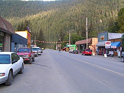
Hyder is a census-designated place in Prince of Wales–Hyder Census Area, Alaska, United States. The population was 48 at the 2020 census, down from 87 in 2010. Hyder is accessible by road only from Stewart, British Columbia. It is popular with motorists wishing to visit Alaska without driving the length of the Alaska Highway. Hyder has no direct access to any Alaskan road. It is the southernmost community in the state that can be reached via car. Hyder is Alaska's easternmost town.

<span class="mw-page-title-main">Haida Gwaii</span> Archipelago in British Columbia, Canada

Haida Gwaii, formerly known as the Queen Charlotte Islands, is an archipelago located between 55–125 km (34–78 mi) off the northern Pacific coast of Canada. The islands are separated from the mainland to the east by the shallow Hecate Strait. Queen Charlotte Sound lies to the south, with Vancouver Island beyond. To the north, the disputed Dixon Entrance separates Haida Gwaii from the Alexander Archipelago in the U.S. state of Alaska.

<span class="mw-page-title-main">Prince Rupert, British Columbia</span> City in British Columbia, Canada

Prince Rupert is a port city in the province of British Columbia, Canada. Its location is on Kaien Island near the Alaskan panhandle. It is the land, air, and water transportation hub of British Columbia's North Coast, and has a population of 12,220 people as of 2016.

<span class="mw-page-title-main">Hecate Strait</span> Strait between Haida Gwaii and mainland British Columbia

Hecate Strait is a wide but shallow strait between Haida Gwaii and the mainland of British Columbia, Canada. It merges with Queen Charlotte Sound to the south and Dixon Entrance to the north. About 140 kilometres (87 mi) wide at its southern end, Hecate Strait narrows in the north to about 48 kilometres (30 mi). It is about 260 kilometres (160 mi) in length.

Pearse Island is an island in western British Columbia, Canada, in the Portland Inlet, an inlet of the Pacific Ocean. The island was first charted in 1793 by George Vancouver during his 1791-95 expedition. It was named by George Henry Richards, captain of HMS Plumper, circa 1860, in honour of William Alfred Rombulow Pearse of the Royal Navy, who had been commander of HMS Alert.

<span class="mw-page-title-main">Portland Canal</span>

Portland Canal is an arm of Portland Inlet, one of the principal inlets of the British Columbia Coast. It is approximately 114 km (71 mi) long. The Portland Canal forms part of the border between southeastern Alaska and British Columbia. The name of the entire inlet in the Nisga'a language is Kʼalii Xkʼalaan, with xkʼalaan meaning "at the back of (someplace)". The upper end of the inlet was home to the Tsetsaut, who after being decimated by war and disease were taken under the protection of the Laxsgiik (Eagle) chief of the Nisga'a, who holds the inlet's title in native law.

<span class="mw-page-title-main">Salmon River (Portland Canal)</span> Braided stream that flows through Hyder, Alaska, and empties into the Portland Canal

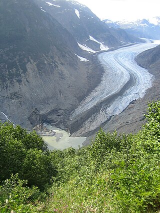
The Salmon River is a braided stream that flows through Hyder, Alaska, and empties into the Portland Canal. It is fed by meltwater from the Salmon Glacier, which is located within British Columbia approximately 13 miles north of its confluence into the Canal and is road-accessible from the town of Stewart, British Columbia. The river crosses the Canada–United States border at 56°02′00″N130°02′00″W.

Anyox was a small company-owned mining town in British Columbia, Canada. Today it is a ghost town, abandoned and largely destroyed. It is located on the shores of Granby Bay in coastal Observatory Inlet, about 60 kilometres southeast of Stewart, British Columbia, and about 20 kilometres, across wilderness east of the tip of the Alaska Panhandle.

<span class="mw-page-title-main">Geography of British Columbia</span>

British Columbia is the westernmost province of Canada, bordered by the Pacific Ocean. With an area of 944,735 km2 (364,764 sq mi) it is Canada's third-largest province. The province is almost four times the size of the United Kingdom and larger than every United States state except Alaska. It is bounded on the northwest by the U.S. state of Alaska, directly north by Yukon and the Northwest Territories, on the east by Alberta, and on the south by the U.S. states of Washington, Idaho, and Montana. Formerly part of the British Empire, the southern border of British Columbia was established by the 1846 Oregon Treaty. The province is dominated by mountain ranges, among them the Canadian Rockies but dominantly the Coast Mountains, Cassiar Mountains, and the Columbia Mountains. Most of the population is concentrated on the Pacific coast, notably in the area of Vancouver, located on the southwestern tip of the mainland, which is known as the Lower Mainland. It is the most mountainous province of Canada.

<span class="mw-page-title-main">British Columbia Coast</span> Coastal region of British Columbia, Canada

The British Columbia Coast, popularly referred to as the BC Coast or simply the Coast, is a geographic region of the Canadian province of British Columbia. As the entire western continental coastline of Canada along the Pacific Ocean is in the province, it is synonymous with being the West Coast of Canada.

The Tsetsaut language is an extinct Athabascan language formerly spoken by the now-extinct Tsetsaut in the Behm and Portland Canal area of Southeast Alaska and northwestern British Columbia. Virtually everything known of the language comes from the limited material recorded by Franz Boas in 1894 from two Tsetsaut slaves of the Nisga'a, which is enough to establish that Tsetsaut formed its own branch of Athabaskan. It is not known precisely when the language became extinct. One speaker was still alive in 1927. The Nisga'a name for the Tsetsaut people is "Jits'aawit"

The Tsetsaut were an Athabaskan-speaking group whose territory was around the head of the Portland Canal, straddling what is now the boundary between the US state of Alaska and the Canadian province of British Columbia. The name T'set'sa'ut, meaning "those of the Interior", was used by the Nisga'a and Gitxsan in reference to their origin as migrants into the region from somewhere farther inland; their use of the term is not to the Tsetsaut alone but also can refer to the Tahltan and the Sekani.

<span class="mw-page-title-main">Masset</span> Village in British Columbia, Canada

Masset is a village in the Haida Gwaii archipelago in British Columbia, Canada. It is located on Masset Sound on the northern coast of Graham Island, the largest island in the archipelago, and is approximately 50 km (31 mi) west of mainland British Columbia. It is the primary western terminus of Trans-Canada Highway 16 and is served by Masset Airport, with flights to Vancouver and Prince Rupert. During the maritime fur trade of the early 19th century, Masset was a key trading site. It was incorporated as a village municipality on May 11, 1961.

<span class="mw-page-title-main">Hartley Bay</span>

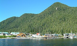
Hartley Bay is a First Nations community on the coast of British Columbia. The village is located at the mouth of Douglas Channel, about 630 kilometres (390 mi) north of Vancouver and 145 kilometres (90 mi) south of Prince Rupert. It is an isolated village accessible only by air and water with a population of 200.

School District 82 Coast Mountains is a school district in northwestern British Columbia between Prince Rupert and Prince George. This includes the major centres of Terrace, Kitimat and extends to the town of Stewart on the BC-Alaska border.

<span class="mw-page-title-main">Wales Island (British Columbia)</span>

Wales Island is an island on the North Coast of British Columbia, Canada, situated east of the Dixon Entrance at the entrance to Portland Inlet.

<span class="mw-page-title-main">Granduc Mine</span>

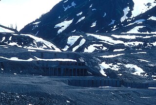
Overlooking the Salmon Glacier, the Granduc Mine is a large copper mine which is situated on a rock ridge between a glacier and a cliff, some 22 miles (35 km) north of Stewart, BC at the north end of Summit Lake. It was an active mine from 1964 to 1984, having closed due to low copper prices.

<span class="mw-page-title-main">Hyder–Stewart Border Crossing</span>

The Hyder–Stewart Border Crossing connects the communities of Hyder, Alaska, and Stewart, British Columbia, on the Canada–United States border. International Street on the American side joins British Columbia Highway 37A on the Canadian side.

<span class="mw-page-title-main">Mount Rainey</span>

Mount Rainey is a 1,983-metre (6,506-foot) summit located in the Coast Mountains of British Columbia, Canada. It is situated 5 kilometers southeast of Stewart, British Columbia, and five kilometers east of Hyder, Alaska. The nearest higher neighbor is Mount Magee, 2.26 km (1.40 mi) to the east-northeast. This mountain's toponym was officially adopted 4 May 1926 on Geological Survey sheet 193A, and confirmed by the Geographical Names Board of Canada in 1953 to remember Robert "Bob" Rainey, the first locator on this mountain who was killed on his mineral claim near Stewart. Precipitation runoff from the mountain drains into the Portland Canal. Topographic relief is significant as the summit rises 1,983 meters above tidewater of the fjord in 4 kilometers.

References

  1. "British Columbia Regional Districts, Municipalities, Corporate Name, Date of Incorporation and Postal Address" (XLS). British Columbia Ministry of Communities, Sport and Cultural Development. Retrieved 2 November 2014.
  2. 1 2 "Stewart (district municipality)". BC Geographical Names .
  3. "Sgamagunt (site)". BC Geographical Names .
  4. Vancouver, George (1798). A voyage of discovery to the North Pacific Ocean and round the world; in which the coast of North-west America has been carefully examined and accurately surveyed : undertaken by his Majesty's command, principally with a view to ascertain the existence of any navigable communication between the North Pacific and North Atlantic Oceans ; and performed in the years 1790, 1791, 1792, 1793, 1794 and 1795, in the discovery sloop of war, and armed tender Chatham, under the command of Captain George Vancouver. London: Printed for G.G. and J. Robinson, Paternoster-Row, and J. Edwards, Pall-Mall.
  5. "Population and dwelling counts: Canada, provinces and territories, and census subdivisions (municipalities), British Columbia". Statistics Canada. 9 February 2022. Retrieved 20 February 2022.
  6. Environment CanadaCanadian Climate Normals 1981–2010, accessed 16 July 2014
  7. "Stewart port receives $13 million for export expansion". Prince Rupert Northern View. 8 August 2019. Retrieved 25 September 2019.
  8. "Canadian Climate Normals 1981–2010 Station Data". Environment Canada. Retrieved 16 July 2014.
  9. "Stewart". Environment Canada. Retrieved 13 May 2016.
  10. "Stewart BCHPA". Environment Canada. Retrieved 13 May 2016.
  11. "Stewart A". Environment Canada. Retrieved 13 May 2016.
  12. "Refroidissement éolien (wind chill)". Données des stations pour le calcul des normales climatiques au Canada de 1981 à 2010 (in French). Environment and Climate Change Canada . Retrieved 26 February 2022.