Summerland | |
---|---|
The Corporation of the District of Summerland [1] | |
View of Summerland in 2006 | |
Nickname: Town of Festivals | |
Coordinates: 49°36′02″N119°40′40″W / 49.60056°N 119.67778°W | |
Country | Canada |
Province | British Columbia |
Region | South Okanagan |
Regional District | Okanagan-Similkameen |
Founded | 1902 |
Government | |
• Mayor | Doug Holmes |
Area | |
• Total | 74.08 km2 (28.60 sq mi) |
• Population Centre | 11.69 km2 (4.51 sq mi) |
Elevation | 454 m (1,490 ft) |
Population | |
• Total | 11,615 |
• Density | 156.8/km2 (406/sq mi) |
• Population Centre | 8,742 |
• Population Centre density | 748.1/km2 (1,938/sq mi) |
Postal code | V0H |
Area code(s) | 250, 778, 236 and 672 |
Website | www |
Year | Pop. | ±% |
---|---|---|
1921 | 1,892 | — |
1931 | 1,791 | −5.3% |
1941 | 2,054 | +14.7% |
1951 | 3,567 | +73.7% |
1956 | 3,893 | +9.1% |
1961 | 4,307 | +10.6% |
1966 | 4,585 | +6.5% |
1971 | 5,551 | +21.1% |
1976 | 6,724 | +21.1% |
1981 | 7,473 | +11.1% |
1986 | 7,755 | +3.8% |
1991 | 9,253 | +19.3% |
1996 | 10,584 | +14.4% |
2001 | 10,713 | +1.2% |
2006 | 10,828 | +1.1% |
2011 | 11,280 | +4.2% |
2016 | 11,615 | +3.0% |
Sources: Statistics Canada [4] |
Summerland is a district municipality on the west side of Okanagan Lake in the interior of British Columbia, Canada. The district is between Peachland to the north and Penticton to the south. The largest centre in the region is Kelowna, approximately 50 km (31 mi) to the north (via Highway 97), and Vancouver is approximately 425 km (264 mi) away to the west. The district is famous for "Bottleneck drive", a system of roads connecting various wineries.
The current mayor is Doug Holmes. The district's (2016 federal) Member of Parliament is Dan Albas of the Conservative Party of Canada. Its member of the Legislative Assembly of British Columbia is British Columbia Liberal Party member, Amelia Boultbee.
In 2006, the District of Summerland celebrated its centennial as an incorporated municipality in 1906, yet the history of settlement in the Summerland area extends beyond that time. Summerland's first inhabitants were the Syilx (Okanagan Salish), with the First Nations boundaries extending from Kamloops to southern Washington state. The area known as "Nicola Prairie" was notably named after the Grand Chief Nicola.
A published map of the Okanagan Valley in 1827 includes only three sites for the entire Okanagan Valley; Nicola Prairie; Lone Tree (north end of Summerland); and Sandy Cove (across the lake from present day Kelowna). Summerland's proud and diverse past includes hunting and fur trading, ranching, orchards and fruit industries, transportation hubs and more recently, tourism. Immigration to the Summerland area commenced in the late 1880s when the first settlers arrived and began diverting water to irrigate orchards. The first commercial orchard was planted in the 1890s in Trout Creek, where a water license was issued to irrigate 1,000 acres (4.0 km2).
The first settlement identified on maps of the Okanagan Valley was Priest Encampment located on the shores of Garnett Lake. Later development began on the shores of Okanagan Lake. The upper benches continued to be an important transportation route and a number of small communities were constructed or were planned for development. They included Upper Trout Creek, Balcomo, the Prairie Valley Townsite, Mineola and Appledale. In 1892 Upper Trout Creek was established.
Summerland's former name was Trout Creek. In the 1890s George Barclay operated the largest cattle ranch in Trout Creek. In 1902, Sir Thomas Shaughnessy bought the Barclay Ranch and formed Summerland; incorporation was not completed until 1906. By the 1920s the present location of downtown Summerland was developed and the earlier areas on the upper benches were not utilized or forgotten. Downtown Summerland (Siwash Flat) was originally part of the Penticton Indian Reserve No. 3 (exchanged between 1904–06 following a mutually agreeable land deal). The subject lands eventually became known as West Summerland.
Present-day Lower Town was the original town site of Summerland. In the early 1900s the Summerland Development Company with Sir Thomas Shaughnessy (president) and J.M. Robinson (manager) primarily responsible for the initial decisions on its development. From the company, the community received water, septic tanks, electricity, a post office, a school and a sawmill. Settlers from across the prairies, eastern Canada and England were drawn to the Summerland area.
By 1907, Summerland had access to Peachland and Penticton with a well-established road system, and a ferry service connecting the community with the eastern shore of Okanagan Lake (Naramata). West Summerland (present day Downtown Summerland) experienced increased importance also in part due to a 1922 fire which destroyed many of the lakeside buildings in Lower Town. [5]
In the 2021 Census of Population conducted by Statistics Canada, Summerland had a population of 12,042 living in 5,084 of its 5,426 total private dwellings, a change of
Panethnic group | 2021 [7] | 2016 [8] | 2011 [9] | 2006 [10] | 2001 [11] | 1996 [12] | 1991 [13] [14] | |||||||
---|---|---|---|---|---|---|---|---|---|---|---|---|---|---|
Pop. | % | Pop. | % | Pop. | % | Pop. | % | Pop. | % | Pop. | % | Pop. | % | |
European [a] | 10,370 | 10,055 | 10,195 | 10,025 | 9,910 | 10,015 | 8,510 | |||||||
Indigenous | 625 | 605 | 380 | 290 | 255 | 70 | 270 | |||||||
South Asian | 235 | 170 | 65 | 145 | 95 | 125 | 50 | |||||||
East Asian [b] | 225 | 125 | 130 | 150 | 235 | 130 | 130 | |||||||
Southeast Asian [c] | 75 | 60 | 20 | 10 | 25 | 25 | 25 | |||||||
African | 65 | 25 | 45 | 45 | 25 | 30 | 0 | |||||||
Latin American | 40 | 40 | 25 | 10 | 10 | 0 | 10 | |||||||
Middle Eastern [d] | 15 | 10 | 0 | 10 | 10 | 20 | 35 | |||||||
Other/Multiracial [e] | 40 | 10 | 0 | 10 | 0 | 10 | — | — | ||||||
Total responses | 11,695 | 11,095 | 10,880 | 10,685 | 10,545 | 10,425 | 9,030 | |||||||
Total population | 12,042 | 11,615 | 11,280 | 10,828 | 10,723 | 10,584 | 9,253 | |||||||
Note: Totals greater than 100% due to multiple origin responses |
According to the 2021 census, religious groups in Summerland included: [7]
Summerland's public school system is operated by School District 67 Okanagan Skaha which operates two elementary schools (Giants Head and Trout Creek), one middle school (Summerland Middle), and one secondary school Summerland Secondary School. Summerland has two private schools (a Montessori school) and Unisus, a day and full-time boarding school with students from the local Okanagan area and from countries around the world. [15]
Summerland is popular because of its situation on Okanagan Lake and sandy beaches, a destination for three major Canadian population centres (Vancouver, Calgary, Edmonton). Both tourism and tourist attractions are a significant industry. Agriculture, featuring fresh tree fruits (peaches, cherries, apricots, apples and pears), and canneries, were the economic engine of the region until the late 20th century. Stone fruit and apples are now produced mainly for the fresh market (local and export). Over the past 20 years, Summerland has become home to several world-renowned wineries, and despite being in a semi-arid climate, has several golf courses. Summerland is also home to the historic Kettle Valley Steam Railway. The railway takes tourists on a trip around the Dale Meadows region of Summerland and further, eventually ending at the famous Trout Creek Trestle. Tourism Summerland [16] guides visitors to Summerland attractions and events.
Summerland is home to one of Canada's largest wine industries. Many of Summerland's wineries are connected by the famed 'Bottleneck Drive.'[ citation needed ]
Summerland is formerly the home of the Summerland Steam of the Kootenay International Junior Hockey League, which relocated to Williams Lake in 2024. The town also used to be the home of the Summerland Sting (2001–2009), and the Summerland Warriors (1999–2000), both of whom played in the same league. Previously the Summerland Buckaroos played in the British Columbia Hockey League from 1983–1988. Summerland is also home to the Summerland Minor Hockey Association (SMHA) known as the Summerland Jets. Football Club (FC) Detonate, founded in 2024, competes in the South Okanagan Men’s Soccer League (SOMSL). [17]
Summerland is located within the Thompson-Okanagan Plateau ecoregion. This is one of the warmest and driest ecoregions in Canada. It is characterized by rolling plateaus and major valley systems of the Okanagan, Thompson and Nicola Rivers. In the summer of 2003, a severe drought nearly rendered the town's reservoir incapable of ensuring a water supply through to the beginning of the next annual replenishment cycle. Since then, awareness of the real need for water conservation measures has begun to be taken seriously, and permanent water use restrictions are now in place.
The immediate ecosystem consists of grasslands in a matrix of bluebunch wheatgrass and sagebrush amongst scattered ponderosa pines. The region has a gently rolling surface covered mainly by glacial deposits. Summerland is home to an extinct volcano, known locally as Giant's Head Mountain – so-named for its gigantic facial profile as viewed from the southeast. This hill dominates the town's land features and provides an hour's hike to the top for an expansive view up and down the Okanagan Valley.
The range of representative wildlife around Summerland includes mule deer, Canada geese, California quail, ravens, coyotes, red wolves (half coyote, half wolf), blue grouse, bald eagles, and black widow spiders. The hills surrounding Summerland is the natural habitat for black bear, white-tailed deer, moose, cougars and bobcats, California big-horn sheep, mountain goats, and rattlesnakes.
Summerland has a humid continental climate with hot, dry summers and cool winters. The mean annual temperature of the major valleys is approximately 10 °C (50 °F) with a summer mean of 21 °C (70 °F) and a winter mean of −3.5 °C (25.7 °F); however, winter months are often very temperate and cold weather usually lasts no more than a few weeks, while summer months often see drought with high daytime and cool night time temperatures. Late fall and most of the winter see very little sunshine in Summerland, but Summerland gets more days with sunshine during the spring than any other place in Canada. The sun makes an appearance on average of 88.4 days each spring.
Because Summerland is located up on a natural bench, it stays relatively warm at night. By comparison, Penticton experiences colder nights as the cool air sinks down into the valley below. These warm nights in a dry climate means that Summerland has the lowest morning relative humidity in Canada from May through September. [18]
Climate data for Summerland | |||||||||||||
---|---|---|---|---|---|---|---|---|---|---|---|---|---|
Month | Jan | Feb | Mar | Apr | May | Jun | Jul | Aug | Sep | Oct | Nov | Dec | Year |
Record high °C (°F) | 15.5 (59.9) | 16.7 (62.1) | 22.2 (72.0) | 28.9 (84.0) | 33.9 (93.0) | 44.7 (112.5) | 40.0 (104.0) | 37.8 (100.0) | 36.8 (98.2) | 28.5 (83.3) | 19.5 (67.1) | 20.7 (69.3) | 44.7 (112.5) |
Mean daily maximum °C (°F) | 1.2 (34.2) | 4.7 (40.5) | 9.8 (49.6) | 15.4 (59.7) | 20.4 (68.7) | 23.9 (75.0) | 28.4 (83.1) | 28.0 (82.4) | 22.4 (72.3) | 13.9 (57.0) | 6.1 (43.0) | 1.7 (35.1) | 14.7 (58.4) |
Daily mean °C (°F) | −1.5 (29.3) | 1.0 (33.8) | 4.8 (40.6) | 9.4 (48.9) | 14.1 (57.4) | 17.6 (63.7) | 21.4 (70.5) | 21.0 (69.8) | 16.0 (60.8) | 9.0 (48.2) | 2.9 (37.2) | −0.9 (30.4) | 9.6 (49.2) |
Mean daily minimum °C (°F) | −4.1 (24.6) | −2.8 (27.0) | −0.2 (31.6) | 3.4 (38.1) | 7.7 (45.9) | 11.2 (52.2) | 14.3 (57.7) | 13.9 (57.0) | 9.6 (49.3) | 4.0 (39.2) | −0.3 (31.5) | −3.5 (25.7) | 4.4 (40.0) |
Record low °C (°F) | −30.0 (−22.0) | −26.7 (−16.1) | −21.7 (−7.1) | −8.9 (16.0) | −5.0 (23.0) | 1.5 (34.7) | 4.4 (39.9) | 5.6 (42.1) | −3.9 (25.0) | −14.0 (6.8) | −23.0 (−9.4) | −29.4 (−20.9) | −30.0 (−22.0) |
Average precipitation mm (inches) | 25.6 (1.01) | 18.5 (0.73) | 20.7 (0.81) | 28.8 (1.13) | 37.1 (1.46) | 42.2 (1.66) | 36.1 (1.42) | 30.2 (1.19) | 20.1 (0.79) | 19.5 (0.77) | 28.0 (1.10) | 30.0 (1.18) | 336.7 (13.26) |
Average rainfall mm (inches) | 10.2 (0.40) | 12.5 (0.49) | 19.1 (0.75) | 28.8 (1.13) | 37.1 (1.46) | 42.2 (1.66) | 36.1 (1.42) | 30.2 (1.19) | 20.1 (0.79) | 19.2 (0.76) | 21.5 (0.85) | 10.1 (0.40) | 287.0 (11.30) |
Average snowfall cm (inches) | 16.1 (6.3) | 7.7 (3.0) | 2.3 (0.9) | 0.0 (0.0) | 0.0 (0.0) | 0.0 (0.0) | 0.0 (0.0) | 0.0 (0.0) | 0.0 (0.0) | 0.2 (0.1) | 6.7 (2.6) | 21.0 (8.3) | 54.0 (21.3) |
Average precipitation days (≥ 0.2 mm) | 10.3 | 9.3 | 9.1 | 11.2 | 11.5 | 11.2 | 9.7 | 8.6 | 5.9 | 7.3 | 12.6 | 12.1 | 118.8 |
Average rainy days (≥ 0.2 mm) | 5.1 | 6.3 | 8.6 | 11.2 | 11.5 | 11.2 | 9.7 | 8.6 | 5.9 | 7.2 | 10.8 | 4.6 | 100.8 |
Average snowy days (≥ 0.2 cm) | 5.8 | 3.3 | 0.9 | 0.0 | 0.0 | 0.0 | 0.0 | 0.0 | 0.0 | 0.1 | 2.5 | 8.1 | 20.7 |
Mean monthly sunshine hours | 40.8 | 93.9 | 160.0 | 195.2 | 248.1 | 256.3 | 302.2 | 283.2 | 223.2 | 148.9 | 64.2 | 42.0 | 2,057.9 |
Percent possible sunshine | 15.2 | 33.1 | 43.5 | 47.4 | 52.2 | 52.7 | 61.6 | 63.3 | 58.8 | 44.4 | 23.4 | 16.5 | 42.7 |
Source: [18] [19] [20] |
Summerland serves as a sister city with Omak, Washington, a city in the United States, [21] and Toyokoro, Hokkaido, a town in Japan. [22]
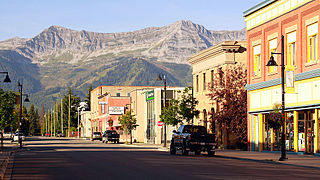
Fernie is a city in the Elk Valley area of the East Kootenay region of southeastern British Columbia, Canada, located on BC Highway 3 on the western approaches to the Crowsnest Pass through the Rocky Mountains. Founded in 1898 and incorporated as the City of Fernie in July 1904, the municipality has a population of over 5,000 with an additional 2,000 outside city limits in communities under the jurisdiction of the Regional District of East Kootenay. A substantial seasonal population swells the city during the winter months.
Vernon is a city in the Okanagan region of the Southern Interior of British Columbia, Canada. It is 440 km (270 mi) northeast of Vancouver. Named after Forbes George Vernon, a former MLA of British Columbia who helped establish the Coldstream Ranch in nearby Coldstream, the City of Vernon was incorporated on 30 December 1892. The City of Vernon has a population of 40,000 (2013), while its metropolitan region, Greater Vernon, had a population of 58,584 as of the 2011 Canadian census. With this population, Vernon is the largest city in the North Okanagan Regional District. A resident of Vernon is called a "Vernonite".
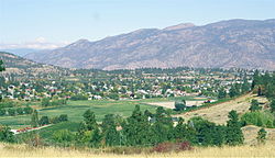
Penticton is a city in the Okanagan Valley of the Southern Interior of British Columbia, Canada, situated between Okanagan and Skaha lakes. In the 2016 Canadian Census, its population was 33,761, while its census agglomeration population was 43,432.
Osoyoos is the southernmost town in the Okanagan Valley in British Columbia between Penticton and Omak. The town is 3.6 km (2.2 mi) north of the United States border in the Washington State and is adjacent to the Osoyoos Indian reserve. The origin of the name Osoyoos was the word sw̓iw̓s meaning "narrowing of the waters" in the local Okanagan language (Syilx'tsn). The "O-" prefix is not indigenous in origin and was attached by settler-promoters wanting to harmonize the name with other place names beginning with O in the Okanagan region. There was a local newspaper, the Osoyoos Times, but merged with the Oliver Chronicle and became the Times Chronicle in May 2020.
Oliver is a town near the south end of the Okanagan Valley in the southern Interior of British Columbia, Canada, with a population of nearly 5,000 people. It is located along the Okanagan River by Tuc-el-nuit Lake between Osoyoos and Okanagan Falls, and is labelled as the Wine Capital of Canada by Tourism British Columbia. It was once "The Home of the Cantaloupe" as well as the "Home of the International Horseshow."
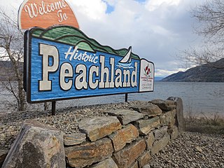
Peachland is a district municipality in the Okanagan Valley on the west side of Okanagan Lake in British Columbia, Canada. It was founded in 1899 by John Moore Robinson, although the region had long been home to the Okanagan people. Peachland is approximately half-an-hour's drive south of the city of Kelowna and about a 20-minute drive north of Summerland. The Okanagan Valley is very narrow in the area and there are few terraces that mark former lake levels and the former lake bottom. As a result, the city is largely located on a steep sidehill. Like many other areas in the Okanagan, Peachland is rapidly growing, with new residents coming from all across Canada. Across the lake from Peachland is Rattlesnake Island, home of the legendary Ogopogo. Peachland is approximately 370 km from Vancouver, British Columbia, on the British Columbia south coast.
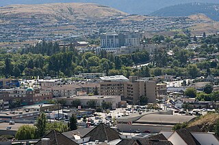
The Thompson–Nicola Regional District is a regional district in the Canadian province of British Columbia. The Canada 2021 Census population was 143,680 and the area covers 44,449.49 square kilometres. The administrative offices are in the main population centre of Kamloops, which accounts for 78 percent of the regional district's population. The only other city is Merritt; other municipally-incorporated communities include the District Municipalities of Logan Lake, Barriere and Clearwater and the Villages of Chase, Ashcroft, Cache Creek, Clinton and Lytton, and also the Mountain Resort Municipality of Sun Peaks.
The Regional District of Central Okanagan (RDCO) is a regional district in the Canadian province of British Columbia, representing two unincorporated Electoral Areas of Central Okanagan East and Central Okanagan West, along with the member municipalities of the City of Kelowna, City of West Kelowna, the District of Lake Country, the District of Peachland, and Westbank First Nation. The RDCO office is located in Kelowna.
North Cowichan is a district municipality established in 1873 on Vancouver Island, in British Columbia, Canada. The municipality is part of the Cowichan Valley Regional District. North Cowichan is noted for a landscape including forests, beaches, rivers, and lakes. The municipality encompasses the communities of Chemainus; Westholme; Crofton; Maple Bay; and "the South End". The latter is an informal name for a built-up area which is essentially a suburb of the City of Duncan, a separate municipality.
The Fraser Valley Regional District (FVRD) is a regional district in British Columbia, Canada. Its headquarters are in the city of Chilliwack. The FVRD covers an area of 13,361.74 km2 (5,159 sq mi). It was created in 1995 by an amalgamation of the Fraser-Cheam Regional District and Central Fraser Valley Regional District and the portion of the Dewdney-Alouette Regional District from and including the District of Mission eastwards.
The Cowichan Valley Regional District is a regional district in the Canadian province of British Columbia that is on the southern part of Vancouver Island, bordered by the Nanaimo and Alberni-Clayoquot Regional Districts to the north and northwest, and by the Capital Regional District to the south and east. As of the 2021 Census, the Regional District had a population of 89,013. The regional district offices are in Duncan.
The City of Enderby is in the North Okanagan region of the Canadian province of British Columbia, between Armstrong and Salmon Arm. It is approximately 80 km north of Kelowna and 130 km east of Kamloops. Highway 97A passes through Enderby and the Shuswap River marks the eastern and northeastern limits of the City. There are two major schools in Enderby: M.V. Beattie Elementary School and A.L. Fortune Secondary School. M.V. Beattie Elementary School was rebuilt in 2012.
Lake Country is a district municipality with a population of approximately 15,000 in the Okanagan Valley region of British Columbia, Canada. It is a part of the Central Okanagan Regional District, and of the Kelowna metropolitan area. The city of Kelowna lies to the south, while the city of Vernon lies to the north. As its name suggests, there are a number of lakes in the vicinity of Lake Country, and outside the municipal boundaries in the hills to the east. Okanagan Lake defines the western boundary of the municipality, while the entirety of Wood Lake and the southernmost portion of Kalamalka Lake are encompassed by it.
Grand Forks is a city in the Boundary Country of the West Kootenay region of British Columbia, Canada. It is located at the confluence of the Granby and Kettle Rivers, the latter being a tributary of the Columbia River. The city is just north of the Canada–United States border, approximately 500 km (310 mi) from Vancouver and 200 km (120 mi) from Kelowna and 23 km (14 mi) west of the resort area of Christina Lake by road.
Houston is a forestry, mining and tourism town in the Bulkley Valley of the Northern Interior of British Columbia, Canada. Its population as of 2021 was 3,052, with approximately 2,000 in the surrounding rural area. It is known as the "steelhead capital" and it has the world's largest fly fishing rod. Houston's tourism industry is largely based on ecotourism and Steelhead Park, situated along Highway 16. Houston is named in honour of the pioneer newspaperman John Houston.
The Regional District of Okanagan-Similkameen (RDOS) is in southern British Columbia, adjacent to the U.S. state of Washington. It is bounded by Fraser Valley Regional District to the west, Thompson-Nicola Regional District and Regional District of Central Okanagan to the north, Regional District of Kootenay Boundary to the east, and by Okanogan County, Washington to the south. At the 2011 census the population was 80,742. The district covers a land area of 10,413.44 square kilometres (4,020.65 sq mi). The administrative offices are in the City of Penticton.
The Regional District of Fraser–Fort George (RDFFG) is a regional district located in the Central Interior of British Columbia, Canada. It is bounded by the Alberta border to the east, the Columbia–Shuswap and Thompson–Nicola regional districts to the south and southeast, Cariboo Regional District to the southwest, the Regional District of Bulkley–Nechako to the west, and the Peace River Regional District to the north and northeast. As of the Canada 2011 Census, Fraser–Fort George had a population of 91,879 and a land area of 51,083.73 km2. The offices of the regional district are located at Prince George.
Coldstream is a district municipality in British Columbia, Canada, located at the northern end of Kalamalka Lake in the Okanagan Valley. Incorporated on December 21, 1906, Coldstream celebrated its centennial in 2006. The municipality is directly southeast of Vernon and is considered part of Greater Vernon. It is a member municipality of, and also the location of the head offices, of the Regional District of North Okanagan.
Spallumcheen is a district municipality in the Canadian province of British Columbia. Located in the Okanagan region between Vernon and Enderby, the township had a population of 5,055 and land area of 255.77 square kilometres (98.75 sq mi) in the Canada 2011 Census. The district, whose official name is the Township of Spallumcheen and which is the oldest rural municipality in the British Columbia Interior, consists primarily of agricultural land surrounding the separately incorporated City of Armstrong. Both Spallumcheen and Armstrong are member municipalities of the Regional District of North Okanagan.
Lake Cowichan is a town located on the east end of Cowichan Lake and, by highway, is 27 kilometres (17 mi) west of Duncan, British Columbia. The town of Lake Cowichan was incorporated in 1944. The Cowichan River flows through the middle of the town. Cowichan River is designated as a Heritage River.