Okanagan Falls (also known as OK Falls) is a community located on the south end of Skaha Lake in British Columbia, Canada.[1][2] It voted to become an incorporated municipality in 2025.
The community was founded in 1893 as Dogtown. The current name derives from a small set of the falls that used to lie on the Okanagan River at the outlet of Skaha Lake. The falls have since been submerged beneath the lake due to the construction of a dam on the river.[3][4]
In 2012, Okanagan Falls expressed interest in incorporating as a municipality,[5] and in December 2020 the Regional District of Okanagan-Similkameen approved a study on incorporating the community as a municipality.[6] A previous attempt at incorporation was rejected by 76percent of voters in 1989. Residents in Okanagan Falls approved the incorporation measure in an election on March 22, 2025, with 53percent in favour. It will become the province's 162nd municipality—the most recent since Sun Peaks in 2010—once the results are confirmed.[7]
Geological features
The namesake Okanagan Falls have long been submerged by the waters of Skaha Lake, which rose as a result of the construction of this small dam. The dam is located just south of the bridge along Highway 97 The dam is a vital component of the flood and irrigation controls of the region.
Nestled at the head of a giant spillway formed as the discharge of Glacial Lake Penticton was constrained between Mount McLellan to the west and Peach Cliff to the east. Okanagan Falls has a diverse assemblage of geological attractions.[8]
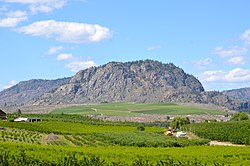
Peach Cliff
Peach Cliff is a dominant landmark to the east of Okanagan Falls. It consists of trachyte of Eocene age. Peach Cliff is home to herds of mule deer and a sizeable herd of California bighorn sheep. Perched high on a spur of Peach Cliff is Balancing Rock, a large glacial erratic supported by a couple of granitic cobbles.[9]
Indian Head
Southwest of Okanagan Falls, are the ragged cliffs of Indian Head, one of the most unusual rock formations in the Okanagan. Consisting of dark volcanic rocks overlying a lighter conglomerate. This formation contains spectacular megabreccia, volcanic and plutonic rocks up to 70m (230ft) across and metamorphic rocks of up to 500m (1,600ft) across.[10]
The observatory was named an IEEE Milestone for first radio astronomical observations using VLBI. There is a self-guided tour available at the facility during daylight hours.
‡This populated place also has portions in an adjacent region
This page is based on this Wikipedia article Text is available under the CC BY-SA 4.0 license; additional terms may apply. Images, videos and audio are available under their respective licenses.