
Oatman is a village in the Black Mountains of Mohave County, Arizona, located at an elevation of 2,710 feet (830 m). It began as a small mining camp when two prospectors struck a $10 million gold find in 1915, though the vicinity had already been settled for a number of years. Oatman's population grew to more than 3,500 in the course of a year.
Neville Langrell "Bill" Barlee was a Canadian politician who was first elected to the Legislative Assembly of British Columbia as a New Democrat in 1988. He served as Minister of Agriculture, Fisheries and Food from 1991 until 1993 and then as Minister of Small Business, Tourism and Culture from 1993 until 1996.

Sandon is a near ghost town located in the foothills of the Selkirk Mountains in the Regional District of Central Kootenay, British Columbia. Once the unofficial capital of the "Silvery Slocan" mining region, only some of the town remains standing.

Greenwood is a city in south central British Columbia. It was incorporated in 1897 and was formerly one of the principal cities of the Boundary Country smelting and mining district. It was incorporated as a city originally and has retained that title despite the population decline following the closure of the area's industries.

Ainsworth Hot Springs, previously named Ainsworth, is a historic village on Kootenay Lake in British Columbia, Canada and has a population of 20. Founded on May 31, 1883, it is the oldest surviving community on Kootenay Lake. Ainsworth Hot Springs is located on Highway 31, 11 miles (18 km) north of Balfour and 12 miles (19 km) south of Kaslo, British Columbia. Today, Ainsworth Hot Springs and the Cody Caves are a popular destination for tourists and spelunkers.
Cascade City or Cascade was a Canadian Pacific Railway construction era boom town in the Boundary Country of the West Kootenay region of British Columbia, Canada. Because of its location near the Canada–United States border, it was also called the "Gateway to the Boundary Country".
Granite Creek is a creek and townsite in British Columbia located in the Similkameen region. Granite Creek flows north into the Tulameen River and joins that river approximately one and a half miles to the east of Coalmont, British Columbia. It is assumed Granite Creek yielded more than $500,000 in placer gold since its discovery. Gold nuggets worth $50 in value were not unusual in the early years. The creek was mined by Europeans and Chinese. Granite Creek was hydraulicked near its mouth in the 1890s.
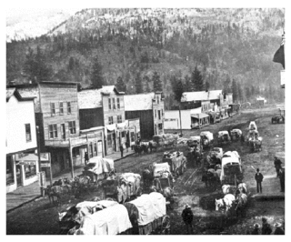
"Granite City" is the informal name for the mining settlement located near Granite Creek. Established during the 1885 gold rush, Granite Creek townsite is now a ghost town in the Similkameen region of British Columbia, Canada.

Camp McKinney is a ghost town in the Boundary Country region of British Columbia, Canada. It is located southeast of Mount Baldy, northeast of Osoyoos.
Carmi is a ghost town in the Boundary Country region of British Columbia, Canada.The town is located on the west side of West Kettle River, east of Penticton, on Hwy 33. Carmi emerged as a silver mining camp just after the turn of the 20th century, named after the nearby mine. The mine in turn was named after the home town of James Dale, Carmi, Illinois.
Boundary Creek is a creek located in the Boundary Country region of British Columbia. The creek is a tributary of the Kettle River. Boundary Creek flows into the Kettle River from the northeast and was the first creek found to be gold bearing in the Boundary Country. It was discovered in 1859 by American prospectors. Boundary Creek was heavily mined in the first decade after its discovery. It has been mined by many since then including Chinese miners. Gold nuggets worth $50 have been recovered from Boundary Creek.
Gladstone is a ghost town located in the Boundary Country region of British Columbia. Gladestone is located near McRae Creek. Today Gladestone is also known as Coryell. In 1898 Gladestone had 3 hotels, 3 stores, a livery stable among other businesses. Gladstone became a town built on mining and the railway. Many prospectors came to the area in order to mine a place called Burnt Basin. By 1899 Gladestone started to decline and eventually became a ghost town.
Carpenter Creek is a creek in the West Kootenay region of British Columbia. The creek flows straight through the town of Sandon.
Jolly Jack's Lost Mine is a legend about a hidden placer mine supposed to be located in the Boundary Country of British Columbia. The mine has been written about by local historians and various magazines. Many have searched for the lost placer mine of Jolly Jack. It is a local legend in the Boundary Country.
Gold Trails and Ghost Towns is a historical documentary show first produced for Canadian syndication, created and produced by television station CHBC-TV in Kelowna, British Columbia and hosted by Mike Roberts with historian storyteller Bill Barlee. The show was filmed in a studio which resembled an old trapper's cabin. Mike and Bill discussed history of the old West by prospectors around 1900 in British Columbia.

Joe Mayer a.k.a. Joseph Mayer was an American businessman, gold prospector and pioneer who founded the town of Mayer, Arizona.


