Gastown is the original settlement that became the core of the city of Vancouver, British Columbia, Canada, and a national historic site and a neighbourhood in the northwest section of the Downtown Eastside, adjacent to Downtown Vancouver.

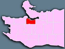
The West End is a neighbourhood in Vancouver, British Columbia, Canada, located between the Coal Harbour neighbourhood and the financial and central business districts of Downtown Vancouver to the east, Stanley Park to the northwest, the English Bay to the west, and Kitsilano to the southwest across the False Creek opening.

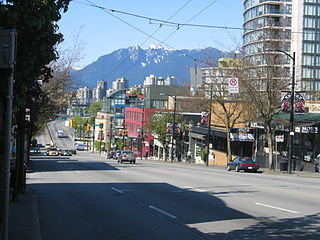
Robson Street is a major southeast-northwest thoroughfare in downtown and West End of Vancouver, British Columbia, Canada. Its core commercial blocks from Burrard Street to Jervis were also known as Robsonstrasse. Its name honours John Robson, a major figure in British Columbia's entry into the Canadian Confederation, and Premier of the province from 1889 to 1892. Robson Street starts at BC Place Stadium near the north shore of False Creek, then runs northwest past Vancouver Library Square, Robson Square and the Vancouver Art Gallery, coming to an end at Lost Lagoon in Stanley Park.

Kitsilano ' is a neighbourhood located in the city of Vancouver, British Columbia, Canada. Kitsilano is named after Squamish Chief August Jack Khatsahlano, and the neighbourhood is located in Vancouver's West Side along the south shore of English Bay, between the neighbourhoods of West Point Grey and Fairview.
Established in 1907, South Granville is an upscale Business Improvement Area (BIA) and neighbourhood south of Vancouver's downtown core, centred along Granville Street and bordered by the neighbourhoods of Kitsilano, Fairview and Shaughnessy.

False Creek is a short narrow inlet in the heart of Vancouver, separating the Downtown and West End neighbourhoods from the rest of the city. It is one of the four main bodies of water bordering Vancouver, along with English Bay, Burrard Inlet, and the Fraser River. Granville Island is located within the inlet.

The Granville Street Bridge or Granville Bridge is an eight-lane fixed cantilever/truss bridge in Vancouver, British Columbia, carrying Granville Street between Downtown Vancouver southwest and the Fairview neighborhood. It spans False Creek and is 27.4 m (90 ft) above Granville Island. The bridge is part of Highway 99.

The Cambie Bridge is a six-lane symmetric, precast, varying-depth-post tension-box girder bridge spanning False Creek in Vancouver, British Columbia. The current bridge opened in 1985, but is the third bridge at the same location. Often referred to as the Cambie Street Bridge, it connects Cambie Street on the south shore of False Creek to both Nelson and Smithe Streets in the downtown peninsula. It is the easternmost of False Creek's fixed crossings; the Burrard and Granville bridges are a little more than a kilometre to the west, and the new Canada Line SkyTrain tunnel is built just west of the Cambie Bridge.

The Vancouver School Board is a school district based in Vancouver, British Columbia, Canada. A board of nine trustees normally manages this district that serves the city of Vancouver and the University Endowment Lands.

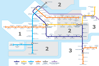
The 98 B-Line was a bus rapid transit line in Metro Vancouver, British Columbia, Canada. It linked Richmond to Downtown Vancouver, with a connection to Vancouver International Airport. It travelled mainly along Granville Street in Vancouver and a dedicated bus lane on No. 3 Road in Richmond. It was operated by Coast Mountain Bus Company and was funded by TransLink. The route was 16 kilometres (9.9 mi) long. The line carried over 18,000 passengers daily. It was discontinued on September 7, 2009, two and a half weeks after the opening of the Canada Line, which replaced it.

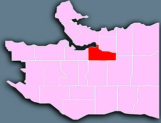
Downtown Vancouver is the main central business district and the city center neighbourhood of Metro Vancouver, located on the northwestern shore of the Burrard Peninsula in the Lower Mainland region of British Columbia. The Downtown occupies most of the north shore of the False Creek inlet, which incises into the Burrard Peninsula creating the namesaked Downtown Peninsula, where the West End neighbourhood and Stanley Park are also located.
Transportation in Vancouver, British Columbia, has many of the features of modern cities worldwide. Unlike many large metropolises, Vancouver has no freeways into or through the downtown area. A proposed freeway through the downtown was rejected in the 1960s by a coalition of citizens, community leaders and planners. This event "signalled the emergence of a new concept of the urban landscape" and has been a consistent element of the city's planning ever since.
Mount Pleasant is a neighbourhood in the city of Vancouver, British Columbia, Canada, stretching from Cambie Street to Clark Drive and from Great Northern Way and 2nd, to 16th and Kingsway. The neighbourhood, once characterized as working-class, has undergone a process of gentrification since the early 1990s, including the area around the Main Street and Broadway intersection.

Olympic Village is an underground station on the Canada Line of Metro Vancouver's SkyTrain rapid transit system. The station is located at the intersection of Cambie Street and West 2nd Avenue, adjacent to the Cambie Street Bridge in Vancouver, British Columbia, Canada.

Oakridge is a neighbourhood in Vancouver, British Columbia, Canada, with a multicultural residential and commercial area. It had a population of 13,030 in 2016, of which approximately 50 percent have Chinese as their mother tongue.

South Cambie is a neighbourhood in the city of Vancouver, British Columbia, Canada, that is generally considered one of the smallest neighbourhoods in the city, both in size and in population. It is wedged between one of the city's largest parks and the upscale neighbourhood of Shaughnessy, and is known for a large cluster of medical facilities.
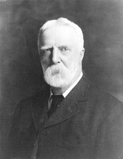
Henry John Cambie was a Canadian surveyor and civil engineer and a notable figure in the completion of Canada's transcontinental railway. He was also a notable pioneer resident of Vancouver.

Georgia Street is an east–west street in the cities of Vancouver and Burnaby, British Columbia, Canada. Its section in Downtown Vancouver, designated West Georgia Street, serves as one of the primary streets for the financial and central business districts, and is the major transportation corridor connecting downtown Vancouver with the North Shore by way of the Lions Gate Bridge. The remainder of the street, known as East Georgia Street between Main Street and Boundary Road and simply Georgia Street within Burnaby, is more residential in character, and is discontinuous at several points.

Broadway is a major east–west thoroughfare in the city of Vancouver, British Columbia, Canada. In Vancouver's numbered avenue grid system, it runs in place of a 9th Avenue, between 8th and 10th. The street has six lanes for most of its course. Portions of the street carry the British Columbia Highway 7 designation.