Shaughnessy, Vancouver

Last updated
Shaughnessy
Neighbourhood
Vancouver Shaughnessy.jpg
Location of Shaughnessy in Vancouver.
CountryFlag of Canada (Pantone).svg  Canada
Province British Columbia
City Vancouver
Shaughnessy Shaughnessy 2018.jpg
Shaughnessy

Shaughnessy is an almost-entirely residential neighbourhood in Vancouver, British Columbia, Canada, spanning about 447 hectares [1] in a relatively central locale. It is bordered by 16th Avenue to the north, 41st Avenue to the south, Oak Street to the east, and East Boulevard to the west. The older section of the neighbourhood, called "First Shaughnessy," is considered more prestigious and is bordered by 16th Avenue to the north, King Edward Avenue to the south, Oak Street to the east, and East Boulevard to the west. In 2016, the population was approximately 8,810. [2] It was named after Thomas Shaughnessy, 1st Baron Shaughnessy, former president of the Canadian Pacific Railway.

Contents

The neighbourhood's residents have an average annual household income of $111,566 ($777,184 in Shaughnessy Heights) and the average house price is $2.89 million, the highest in Vancouver. [3] [4] It is also the site of many historical homes, especially in First Shaughnessy. Of the neighbourhood's homes 51.5% were built before or during World War II, compared with 20.8% for the city at large. [1] This is largely due to the 1981 First Shaughnessy Official Development Plan by-law, which promotes private property ownership and single-family dwelling, while limiting property subdivision and population density. [5]

History

The neighbourhood was created in 1907 by the Canadian Pacific Railway, the largest real estate developer in Canada. It was meant as an alternative to the West End, which was the traditional home for the budding city's elite. [6] Thanks to aggressive marketing by the railway, highly regulated development, and a stronger degree of exclusiveness, it gradually took the latter's status over the past century. Shaughnessy is known for its elegant tree-lined streets and large properties. In First Shaughnessy, Angus Drive and Osler Street have a tree-lined median in addition to the trees along the edge of the road.

Crescent Park as seen in the 1930s Crescent Park, Shaughnessy, Vancouver.jpg
Crescent Park as seen in the 1930s

Demographics

As of 2016, Shaughnessy has 8,430 people, down 4.3% from the previous 5 years. 10.8% of the population is under the age of 20; 23.8% is between 20 and 39; 34% is between 40 and 64; and 21.6% is 65 or older. 51.8% of Shaughnessy residents speak English as a first language, 23.8% speak Chinese, less than 5% speak Tagalog, Korean, Spanish and French. The median household income is $111,566 and 15.5% of its population lives in low-income households. The unemployment rate is 4.7%. [7]

Panethnic groups in the Shaughnessy neighbourhood (2001−2016)
Panethnic
group
2016 [8] 2006 [9] 2001 [10]
Pop. %Pop.%Pop.%
European [lower-alpha 1] 3,6005,0505,305
East Asian [lower-alpha 2] 3,5552,9452,970
South Asian 270235135
Southeast Asian [lower-alpha 3] 210280185
Middle Eastern [lower-alpha 4] 756520
Latin American 651525
Indigenous 652510
African 502030
Other/Multiracial [lower-alpha 5] 1058085
Total responses7,9908,7208,760
Total population8,4308,9009,020
Note: Totals greater than 100% due to multiple origin responses

Education

Shaughnessy is home to Little Flower Academy, Vancouver College, and York House School. The public elementary schools are Shaughnessy Elementary and Quilchena Elementary. There is one public high school in Shaughnessy, Point Grey Secondary. The neighbourhood is in the catchment area of each of Eric Hamber Secondary School, in Oakridge, or Prince of Wales Secondary School, in Arbutus Ridge.

Parks

Shaughnessy has five parks, including Shaughnessy Park, formally known as Crescent Park, and Angus Park in First Shaughnessy. The other three parks in Shaughnessy are Devonshire Park, Kerrisdale Park, and VanDusen Botanical Garden, located between 33rd and 41st Avenues. The Arbutus Greenway, purchased by the City of Vancouver from Canadian Pacific Railway, stretches along the western border of Shaughnessy from 41st Avenue to 16th Avenue. [11]

Notes

  1. Statistic includes all persons that did not make up part of a visible minority or an indigenous identity.
  2. Statistic includes total responses of "Chinese", "Korean", and "Japanese" under visible minority section on census.
  3. Statistic includes total responses of "Filipino" and "Southeast Asian" under visible minority section on census.
  4. Statistic includes total responses of "West Asian" and "Arab" under visible minority section on census.
  5. Statistic includes total responses of "Visible minority, n.i.e." and "Multiple visible minorities" under visible minority section on census.

Related Research Articles

<span class="mw-page-title-main">Port Coquitlam</span> City in British Columbia, Canada

Port Coquitlam is a city in British Columbia, Canada. Located 27 km (17 mi) east of Vancouver, it is on the north bank of the confluence of the Fraser River and the Pitt River. Coquitlam borders it on the north, the Coquitlam River borders it on the west, and the city of Pitt Meadows lies across the Pitt River from it. Port Coquitlam is bisected by Lougheed Highway and the Canadian Pacific Railway. Port Coquitlam is often referred to as "PoCo". It is Canada's 93rd-largest municipality by population.

<span class="mw-page-title-main">Kitsilano</span> Neighbourhood of Vancouver in British Columbia, Canada

Kitsilano is a neighbourhood located in the city of Vancouver, British Columbia, Canada. Kitsilano is named after Squamish chief August Jack Khatsahlano, and the neighbourhood is located in Vancouver's West Side along the south shore of English Bay, between the neighbourhoods of West Point Grey and Fairview. The area is mostly residential with two main commercial areas, West 4th Avenue and West Broadway, known for their retail stores, restaurants and organic food markets.

<span class="mw-page-title-main">Kerrisdale</span> Neighborhood in Vancouver, BC, Canada

Kerrisdale is a neighbourhood in the city of Vancouver, British Columbia, Canada.

<span class="mw-page-title-main">Langley, British Columbia (city)</span> City in British Columbia, Canada

The City of Langley, commonly referred to as Langley City, or just Langley, is a municipality in the Metro Vancouver Regional District in British Columbia, Canada. It lies directly east of Surrey, adjacent to the Cloverdale area, and is surrounded elsewhere by the Township of Langley, bordered by its neighbourhoods of Willowbrook to the north, Murrayville to the east, and Brookswood and Fern Ridge to the south.

<span class="mw-page-title-main">Hastings–Sunrise</span> Neighbourhood of Vancouver in British Columbia, Canada

Hastings–Sunrise is a neighbourhood located in the northeastern corner of the city of Vancouver, British Columbia.

<span class="mw-page-title-main">Strathcona, Vancouver</span> Neighbourhood in Vancouver, Metro Vancouver

Strathcona is the oldest residential neighbourhood of Vancouver, British Columbia, Canada. Officially a part of the East Side, it is bordered by Downtown Vancouver's Chinatown neighbourhood and the False Creek inlet to the west, Downtown Eastside to the north, Grandview-Woodland to the east, and Mount Pleasant to the south of Emily Carr University and the Canadian National Railway and Great Northern Railway classification yards.

<span class="mw-page-title-main">Marpole</span> Neighbourhood in Vancouver, British Columbia, Canada

Marpole, originally a Musqueam village named c̓əsnaʔəm, is a mostly residential neighbourhood of 23,832 in 2011, located on the southern edge of the city of Vancouver, British Columbia, immediately northeast of Vancouver International Airport, and is approximately bordered by Angus Drive to the west, 57th Avenue to the north, Ontario Street to the east and the Fraser River to the south. It has undergone many changes in the 20th century, with the influx of traffic and development associated with the construction of the Oak Street Bridge and the Arthur Laing Bridge.

<span class="mw-page-title-main">Kensington–Cedar Cottage</span> Neighborhood in Vancouver, British Columbia, Canada

Kensington–Cedar Cottage is one of the most ethnically diverse neighbourhoods in east Vancouver, British Columbia, Canada. The neighbourhood is approximately 7.23 square kilometres (2.79 sq mi) in area.
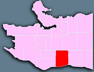
<span class="mw-page-title-main">Downtown Vancouver</span> Neighbourhood of Vancouver in British Columbia, Canada

Downtown Vancouver is the central business district and the city centre neighbourhood of Vancouver, Canada, on the northwestern shore of the Burrard Peninsula in the Lower Mainland region of British Columbia. It occupies most of the north shore of the False Creek inlet, which cuts into the Burrard Peninsula creating the Downtown Peninsula, where the West End neighbourhood and Stanley Park are also located.

<span class="mw-page-title-main">Riley Park–Little Mountain</span> Neighbourhood in Vancouver, British Columbia, Canada

Riley Park–Little Mountain is a neighbourhood in Vancouver, British Columbia. Its boundaries are 41st Avenue to the south, 16th Avenue to the north, Cambie Street to the west, and Fraser Street to the east. The main commercial thoroughfare of the neighbourhood is Main Street.

<span class="mw-page-title-main">Arbutus Ridge</span> Place in British Columbia, Canada

Arbutus Ridge is an affluent residential neighbourhood in Vancouver's West Side. It is bordered by 16th Avenue in the north, 41st Avenue in the south, Mackenzie Street in the west, and East Boulevard in the east. The neighbourhood is characterized by larger than average lot sizes, with stately homes on tree-lined streets.
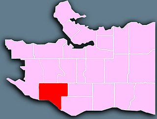
<span class="mw-page-title-main">Fairview, Vancouver</span> Place in British Columbia, Canada

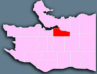
Fairview is a neighbourhood on the west side of the city of Vancouver, British Columbia, Canada. It runs from False Creek in the north to 16th Avenue in the south, and from Burrard Street in the west to Cambie Street in the east.

<span class="mw-page-title-main">Dunbar–Southlands</span> Neighbourhood in Lower Mainland, British Columbia, Canada

Dunbar–Southlands is a neighbourhood on the western side of Vancouver, British Columbia, Canada, that stretches north from the Fraser River and covers most of the land between the mouth of the Fraser and English Bay.

<span class="mw-page-title-main">Killarney, Vancouver</span> Neighbourhood in Vancouver, British Columbia, Canada

Killarney is a neighbourhood in East Vancouver, British Columbia with a population of over 28,000 in 2011 and lies in the far southeast corner of the city. It is on the south slope of the ridge that rises above the Fraser River, and contains a collection of single-family residences with a few multi-family homes as well as the townhouses and high-rises of the Fraserlands development along the river.

<span class="mw-page-title-main">Grandview–Woodland</span> Neighbourhood in Lower Mainland, British Columbia, Canada

Grandview–Woodland, also commonly known as Grandview–Woodlands, is a neighbourhood in Vancouver, British Columbia, Canada to the east of the downtown area, stretching south from the shores of Burrard Inlet and encompassing portions of the popular Commercial Drive area. It is a mature neighbourhood in Vancouver that is a vibrant mixture of commercial, industrial, single-family and multi-family residential with a rich ethnic history and features.

<span class="mw-page-title-main">Mount Pleasant, Vancouver</span> Neighborhood of Vancouver, British Columbia, Canada

Mount Pleasant is a neighbourhood in the city of Vancouver, British Columbia, Canada, stretching from Cambie Street to Clark Drive and from Great Northern Way and 2nd, to 16th and Kingsway. The neighbourhood, once characterized as working-class, has undergone a process of gentrification since the early 1990s, including the area around the Main Street and Broadway intersection.

<span class="mw-page-title-main">Oakridge, Vancouver</span> Neighbourhood in Vancouver, British Columbia, Canada

Oakridge is a neighbourhood in Vancouver, British Columbia, Canada, with a multicultural residential and commercial area. It had a population of 13,030 in 2016, of which approximately 50 percent have Chinese as their mother tongue.

<span class="mw-page-title-main">Renfrew–Collingwood</span> Neighbourhood in Vancouver, British Columbia, Canada

Renfrew–Collingwood is a large neighbourhood that lies on the eastern side of Vancouver, British Columbia, Canada, on its boundary with Burnaby and encompassing an area that was one of the earlier developed regions of the city. It is a diverse area that includes a substantial business community in several areas, as well as some of the fastest-growing residential sectors of Vancouver. In 2011, the neighbourhood had a population of 50,500, 38.4% of whom claim Chinese as their first language.

<span class="mw-page-title-main">South Cambie</span>

South Cambie is a neighbourhood in the city of Vancouver, British Columbia, Canada, that is generally considered one of the smallest neighbourhoods in the city, both in size and in population. It is wedged between one of the city's largest parks and the upscale neighbourhood of Shaughnessy, and is known for a large cluster of medical facilities.

<span class="mw-page-title-main">Vancouver Granville</span> Federal electoral district in British Columbia, Canada

Vancouver Granville is a federal electoral district in British Columbia, Canada, that has been represented in the House of Commons of Canada since 2015. The district includes all or significant portions of the Kerrisdale, Marpole, Oakridge, Shaughnessy, South Cambie, Fairview and Riley Park–Little Mountain neighbourhoods. Based on the Canada 2011 Census data, the population of the district is 99,886.

References

  1. 1 2 "Community Statistics Census Data: Shaughnessy" (PDF). 2001. Archived from the original (PDF) on 2007-09-30. Retrieved 2007-07-09.
  2. "Shaughnessy-census-data.pdf" (PDF). City of Vancouver - vancouver.ca. Retrieved 28 March 2022.
  3. "4. Shaughnessy Heights, Vancouver | Canada's richest neighbourhoods 2014: The top 10 - Yahoo Finance Canada". Archived from the original on 2015-04-02. Retrieved 2015-03-24.
  4. http://vancouver.ca/files/cov/Shaughnessy-census-data.pdf [ bare URL PDF ]
  5. "First Shaughnessy Official Development Plan" (PDF) (Press release). City of Vancouver. 1998-04-01. Retrieved 2007-07-09.
  6. "Walking Tour: Shaughnessy". 2003-06-03. Retrieved 2007-07-09.
  7. "Shaughnessy-census-data.pdf" (PDF). City of Vancouver - vancouver.ca. Retrieved 28 March 2022.
  8. Open Data Portal, City Of Vancouver (2018-04-10). "Census local area profiles 2016". opendata.vancouver.ca. Retrieved 2023-03-20.
  9. Open Data Portal, City Of Vancouver (2013-03-25). "Census local area profiles 2006". opendata.vancouver.ca. Retrieved 2023-03-20.
  10. Open Data Portal, City Of Vancouver (2013-03-25). "Census local area profiles 2001". opendata.vancouver.ca. Retrieved 2023-03-20.
  11. "City of Vancouver buys Arbutus Corridor for $55 million". Vancity Buzz. 2016-03-07. Retrieved 2017-04-29.

Sources

Coordinates: 49°14′42″N123°07′59″W / 49.245°N 123.133°W / 49.245; -123.133