
The West End is a neighbourhood in Vancouver, British Columbia, Canada, located between the Coal Harbour neighbourhood and the financial and central business districts of Downtown Vancouver to the east, Stanley Park to the northwest, the English Bay to the west, and Kitsilano to the southwest across the False Creek opening.

Fernwood is a neighbourhood near downtown Victoria, British Columbia, Canada, bounded by the neighbourhoods of North/South Jubilee, North Park, Fairfield, Rockland, Hillside-Quadra, Oaklands and Harris Green.

The Musqueam Nation is a First Nation whose traditional territory encompasses the western half of what is now Greater Vancouver, in British Columbia, Canada. It is governed by a band council and is known officially as the Musqueam Indian Band under the Indian Act. "Musqueam" is an anglicization of the Hunquminum name xʷməθkʷəy̓əm, which means "place of the river grass" or "place where the river grass grows".

Arbutus Ridge is an affluent residential neighbourhood in Vancouver's West Side. It is bordered by 16th Avenue in the north, 41st Avenue in the south, Mackenzie Street in the west, and East Boulevard in the east. The neighbourhood is characterized by larger than average lot sizes, with stately homes on tree-lined streets.
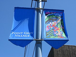
West Point Grey is a neighbourhood in the northwest of the city of Vancouver, British Columbia, Canada. It is on Point Grey and bordered by 16th Avenue to the south, Alma Street to the east, English Bay to the north, and Blanca Street to the west. Notable beaches within West Point Grey include Spanish Banks, Locarno and Jericho. Immediately to the south is Pacific Spirit Regional Park and to the east is Kitsilano.

Renfrew–Collingwood is a large neighbourhood that lies on the eastern side of Vancouver, British Columbia, Canada, on its boundary with Burnaby and encompassing an area that was one of the earlier developed regions of the city. It is a diverse area that includes a substantial business community in several areas, as well as some of the fastest-growing residential sectors of Vancouver. In 2011, the neighbourhood had a population of 50,500, 38.4% of whom claim Chinese as their first language.
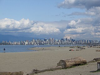
Spanish Banks are a series of beaches in the city of Vancouver, British Columbia, Canada, located along the shores of English Bay in the West Point Grey neighbourhood. Spanish Banks is located between Locarno Beach to the east and the grounds of the University of British Columbia to the west.

Shaughnessy is an almost-entirely residential neighbourhood in Vancouver, British Columbia, Canada, spanning about 447 hectares in a relatively central locale. It is bordered by 16th Avenue to the north, 41st Avenue to the south, Oak Street to the east, and East Boulevard to the west. The older section of the neighbourhood, called "First Shaughnessy," is considered more prestigious and is bordered by 16th Avenue to the north, King Edward Avenue to the south, Oak Street to the east, and East Boulevard to the west. In 2016, the population was approximately 8,810. It was named after Thomas Shaughnessy, 1st Baron Shaughnessy, former president of the Canadian Pacific Railway.
Fairfield is a neighbourhood of Victoria, British Columbia. It is bounded by the James Bay, Downtown, Harris Green, Fernwood, Rockland, and Gonzales neighbourhoods, and meets the Strait of Juan de Fuca to the south.

James Bay is a high density neighbourhood of Victoria, British Columbia, Canada. It is the oldest residential neighbourhood on the west coast of North America that is north of San Francisco. It occupies the south side of the Inner Harbour close to downtown. Access to the neighbourhood is along Belleville Street, Government Street, Douglas Street and Dallas Road.
Point Grey is a headland marking the southern entrance to English Bay and Burrard Inlet in British Columbia, Canada. The headland is the site of Wreck Beach, Tower Beach, Point Grey Beach and most notably, since 1925, on its top is the Point Grey Campus of the University of British Columbia.

Gordon Head is a seaside neighbourhood in the municipality of Saanich in Greater Victoria, British Columbia, Canada. Gordon Head lies north of McKenzie Avenue and east of the Blenkinsop Valley. The University of Victoria is located partly within Gordon Head along the southeast boundary. Finnerty Road separates Gordon Head from the adjacent neighbourhood of Cadboro Bay. The local area is dominated physically by Mount Douglas, a coastline along Haro Strait, and the central plateau.
Originally known as Capilano Estates, the British Properties is a residential area in West Vancouver, British Columbia, Canada. The 4,000 acre area was sold by the municipality of West Vancouver to the British Pacific Properties Corporation in 1931, which continues to develop the land to the present day.
The Comox Valley Regional District is a regional district in British Columbia, Canada. It was created on February 15, 2008, encompassing the southeastern portions of the former Regional District of Comox-Strathcona, and centred about the Comox Valley. The partition left the new Comox Valley Regional District with only 8.4 percent of the former Comox-Strathcona's land area, but 57.9 percent of its population. The CVRD covers an area of 2,425 square kilometres, of which 1,725 square kilometres is land, and serves a population of 72,445 according to the 2023 Census. The district borders the Strathcona Regional District to the northwest, the Alberni-Clayoquot Regional District to the southwest, and the Regional District of Nanaimo to the southeast, as well as the qathet Regional District along the Strait of Georgia to the east.

Rockland is a historic neighbourhood of Victoria, British Columbia, Canada, located just southeast of downtown and northeast of Beacon Hill Park, and comprising the northern portion of the official city neighbourhood of Fairfield. Its boundaries are imprecise but the area roughly flanks Rockland Avenue.
Stanley Park is a neighbourhood of the West End in Vancouver, British Columbia, Canada. It is designated as the area lying between Denman Street and the boundary of Stanley Park proper. It is high density, like most of the West End, and is known for being a more affluent area of the West End and, once away from Denman Street, also one of the quietest on the downtown peninsula. Condominium properties facing the park are some of the most expensive in the city. The extreme southwest of the area overlaps with the English Bay neighbourhood.
Named for, and located adjacent to the bay of the same name, Boundary Bay is a residential neighbourhood in the community of Tsawwassen. Directly south of the neighbourhood, and across the international border, is the residential neighbourhood of Maple Beach, Washington, in Point Roberts, Washington. The traditional name of the location in the Downriver dialect of the Halkomelem language is Chiltinm or Chiltenm. The Boundary Bay Airport is a notable inclusion in this area.
South Oak Bay is a neighbourhood located in the Municipality of Oak Bay, British Columbia, to the south of Oak Bay Avenue and lying east of the boundary between Oak Bay and Victoria, British Columbia.

Victoria West, commonly called Vic West, is a historic neighbourhood of the city of Victoria, British Columbia, Canada, located just west of downtown across Victoria Harbour, bordering on the Township of Esquimalt.
