
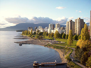
Vancouver is a major city in western Canada, located in the Lower Mainland region of British Columbia. As the most populous city in the province, the 2021 Canadian census recorded 662,248 people in the city, up from 631,486 in 2016. The Greater Vancouver area had a population of 2.6 million in 2021, making it the third-largest metropolitan area in Canada. Greater Vancouver, along with the Fraser Valley, comprises the Lower Mainland with a regional population of over 3 million. Vancouver has the highest population density in Canada, with over 5,700 people per square kilometre, and fourth highest in North America.

420, 4:20 or 4/20 is cannabis culture slang for marijuana and hashish consumption, especially smoking around the time 4:20 pm (16:20). It also refers to cannabis-oriented celebrations that take place annually on April 20.

Stanley Park is a 405-hectare (1,001-acre) public park in British Columbia, Canada that makes up the northwestern half of Vancouver's Downtown Peninsula, surrounded by waters of Burrard Inlet and English Bay. The park borders the neighbourhoods of West End and Coal Harbour to its southeast, and is connected to the North Shore via the Lions Gate Bridge. The historic lighthouse on Brockton Point marks the park's easternmost point. While it is not the largest of its kind, Stanley Park is about one-fifth larger than New York City's 340-hectare (840-acre) Central Park and almost half the size of London's 960-hectare (2,360-acre) Richmond Park.

The Vancouver Art Gallery (VAG) is an art museum in Vancouver, British Columbia, Canada. The museum occupies a 15,300-square-metre-building (165,000 sq ft) adjacent to Robson Square in downtown Vancouver, making it the largest art museum in Western Canada by building size. Designed by Francis Rattenbury, the building the museum occupies was originally opened as a provincial courthouse, before it was re-purposed for museum use in the early 1980s. The building was designated the Former Vancouver Law Courts National Historic Site of Canada in 1980.

The West End is a neighbourhood in Vancouver, British Columbia, Canada, located between the Coal Harbour neighbourhood and the financial and central business districts of Downtown Vancouver to the east, Stanley Park to the northwest, the English Bay to the west, and Kitsilano to the southwest across the False Creek opening.

Parksville is a city on Vancouver Island in British Columbia, Canada. As of the 2021 Census, Parksville's population was 13,642, representing a 9.5% increase over the 2016 Census.

The Lions Gate Bridge, opened in 1938 and officially known as the First Narrows Bridge, is a suspension bridge that crosses the first narrows of Burrard Inlet and connects the City of Vancouver, British Columbia, to the North Shore municipalities of the District of North Vancouver, the City of North Vancouver, and West Vancouver. The term "Lions Gate" refers to the Lions, a pair of mountain peaks north of Vancouver. Northbound traffic on the bridge heads in their general direction. A pair of cast concrete lions, designed by sculptor Charles Marega, were placed on either side of the south approach to the bridge in January 1939.

John Deighton, better known as "Gassy Jack", was a bar-owner in British Columbia. The Gastown neighbourhood of Vancouver, British Columbia takes its name from him.

White Rock is a city in British Columbia, Canada, and a member municipality of the Metro Vancouver Regional District. It borders Semiahmoo Bay to the south and is surrounded on three sides by Surrey. To the southeast across a footbridge lies the Semiahmoo First Nation, which is within the borders of Surrey. Semiahmoo Bay and the Southern Gulf Islands in the Strait of Georgia are also to the south.

Salmon Arm is a city in the Columbia Shuswap Regional District of the Southern Interior of the Canadian province of British Columbia that has a population of 17,706 (2016). Salmon Arm was incorporated as a municipal district on May 15, 1905. The city of Salmon Arm separated from the district in 1912, but was downgraded to a village in 1958. In 1970, the city of Salmon Arm once again reunited with the District Municipality. Salmon Arm once again became a city in 2005, and is now the location of the head offices of the Columbia-Shuswap Regional District. It is a tourist town in the summer, with many beaches, camping facilities and house boat rentals. Salmon Arm is home to the longest wooden freshwater wharf in North America.

Kitsilano is a neighbourhood located in the city of Vancouver, British Columbia, Canada. Kitsilano is named after Squamish chief August Jack Khatsahlano, and the neighbourhood is located in Vancouver's West Side along the south shore of English Bay, between the neighbourhoods of West Point Grey and Fairview. The area is mostly residential with two main commercial areas, West 4th Avenue and West Broadway, known for their retail stores, restaurants and organic food markets.
English Bay is an open bay northwest of the Burrard Peninsula in British Columbia, Canada, extending from the headland between Siwash Rock and Prospect Point on Vancouver's Downtown peninsula in the northeast, to the northwestern tip of Point Grey in the southwest. The bay encompasses the coasts of Stanley Park, the West End, Kitsilano, West Point Grey and the University Endowment Lands, and makes up the southeastern portion of the outer Burrard Inlet. There is a narrow inlet named False Creek at its eastern end.

The Granville Street Bridge or Granville Bridge is an eight-lane fixed cantilever/truss bridge in Vancouver, British Columbia, Canada, carrying Granville Street between Downtown Vancouver southwest and the Fairview neighborhood. It spans False Creek and is 27.4 m (90 ft) above Granville Island. The bridge is part of Highway 99.
The Honda Celebration of Light is an annual musical fireworks competition in Vancouver, British Columbia, Canada. The first "Symphony of Fire" was held from July 25 to August 5, 1990. The celebration is one of Vancouver's largest and most well known festivals, and is recognized as the longest running off-shore fireworks competitions in the world. The multiple-day event has an estimated annual attendance of 1.4 million people.

Port Hardy is a district municipality in British Columbia, Canada located on the north-east end of Vancouver Island. Port Hardy has a population of 3,902 as of the 2021 census.
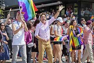
The Vancouver Pride Parade and Festival is an annual LGBT Pride event, held each year in Vancouver, British Columbia, to celebrate lesbian, gay, bisexual, and transgender people and their allies. It is run by the Vancouver Pride Society (VPS), a not-for-profit, volunteer-run organization that seeks to "produce inclusive, celebratory events, and advocacy for LGBTQAI2S+". Vancouver's Pride Parade is the largest parade of any kind in Western Canada.

USS Coronis (ARL-10) was one of 39 Achelous-class repair ship landing craft built for the United States Navy during World War II. Named for Coronis, she was the only US Naval vessel to bear the name.
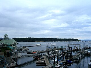
Nanaimo Harbour, also known as the Port of Nanaimo, is a natural harbour on the east coast of Vancouver Island in the Canadian province of British Columbia. The city of Nanaimo runs along the west side of the harbour. Three islands, Newcastle, Protection, and Gabriola, along with Duke Point, form the eastern edge. The Port of Nanaimo includes the Inner Harbour, Nanaimo River estuary, Departure Bay, the waters on the east side of Newcastle and Protection Islands, and Northumberland Channel. The port is under the management of the Nanaimo Port Authority.
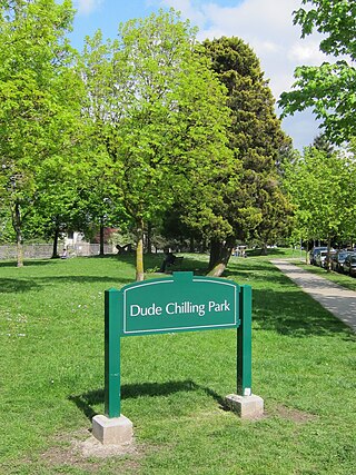
Dude Chilling Park is a sign installation, originally created as a prank, which now has official public art status in Vancouver, British Columbia, Canada. It is located on the southwest corner of Guelph Park at the 2300 block of Brunswick Street in the Mount Pleasant area of the city. It references the park's sculpture "Reclining Figure".

OneCity Vancouver is a municipal political party in Vancouver, British Columbia, Canada. It was founded in 2014 by independent activists and former members of the left-wing Coalition of Progressive Electors (COPE), including David Chudnovsky and Rafael Joseph Aquino; Aquino was OneCity's first candidate to run for public office.

