Related Research Articles

Bowen Island, British Columbia, is an island municipality that is part of Metro Vancouver. Bowen Island is within the jurisdiction of the Islands Trust. Located in Howe Sound, it is approximately 6 kilometres (3.7 mi) wide by 12 kilometres (7.5 mi) long, with the island at its closest point about 3 kilometres (1.9 mi) west of the mainland. There is regular ferry service from Horseshoe Bay provided by BC Ferries, as well as semi-regular water taxi services. The population of 4,256 is supplemented in the summer by roughly 1,500 visitors, as Bowen Island regularly receives travelers in the summer season. The island has a land area of 50.12 km2 (19.35 sq mi).
Gibsons is a coastal community of 4,605 in southwestern British Columbia, Canada on the Strait of Georgia.

RCMPVSt. Roch is a Royal Canadian Mounted Police schooner, the first ship to completely circumnavigate North America, and the second vessel to transit the Northwest Passage. She was the first ship to complete the Northwest Passage in the west to east direction, using the same route that Amundsen on the sailing vessel Gjøa had traversed east to west, 38 years earlier.

The Burrard Peninsula is a peninsula in the Lower Mainland region of British Columbia, Canada, bounded by the Burrard Inlet to the north, the Georgia Strait to the west, the North Arm of Fraser River to the south, and the Pitt River and Douglas Island to the east. The City of Vancouver occupies almost all of the western half of the peninsula, and the Cities of Burnaby and New Westminster occupy more than half of the eastern half. At its northeastern end, the peninsula is connected to the Eagle Mountain and Mount Burke of the Coast Mountains via a small isthmus at the center of the Tri-Cities.

VanDusen Botanical Garden is a botanical garden situated in Vancouver, British Columbia, in the Shaughnessy neighborhood. It is located at the northwest corner of 37th Avenue and Oak Street. It is named for local lumberman and philanthropist Whitford Julian VanDusen.

Green College is a centre for interdisciplinary scholarship and a community of scholars at the University of British Columbia founded by Cecil Howard Green and Ida Green.

Kensington–Cedar Cottage is one of the most ethnically diverse neighbourhoods in east Vancouver, British Columbia, Canada. The neighbourhood is approximately 7.23 square kilometres (2.79 sq mi) in area.

Riley Park–Little Mountain is a neighbourhood in Vancouver, British Columbia. Its boundaries are 41st Avenue to the south, 16th Avenue to the north, Cambie Street to the west, and Fraser Street to the east. The main commercial thoroughfare of the neighbourhood is Main Street.
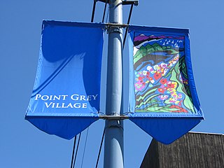
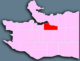
West Point Grey is a neighbourhood in the northwest of the city of Vancouver, British Columbia, Canada. It is located on Point Grey and is bordered by 16th Avenue to the south, Alma Street to the east, English Bay to the north, and Blanca Street to the west. Notable beaches within the West Point Grey boundary include Spanish Banks, Locarno and Jericho. Immediately to the south is Pacific Spirit Regional Park and to the east is Kitsilano.
Mount Pleasant is a neighbourhood in the city of Vancouver, British Columbia, Canada, stretching from Cambie Street to Clark Drive and from Great Northern Way and 2nd, to 16th and Kingsway. The neighbourhood, once characterized as working-class, has undergone a process of gentrification since the early 1990s, including the area around the Main Street and Broadway intersection.

Renfrew–Collingwood is a large neighbourhood that lies on the eastern side of Vancouver, British Columbia, Canada, on its boundary with Burnaby and encompassing an area that was one of the earlier developed regions of the city. It is a diverse area that includes a substantial business community in several areas, as well as some of the fastest-growing residential sectors of Vancouver. In 2011, the neighbourhood had a population of 50,500, 38.4% of whom claim Chinese as their first language.
Sunset is the most ethnically diverse neighbourhood in Vancouver, British Columbia. It is located in the south-east quadrant of the city. Surrounding the multicultural Fraser Street district, Sunset is bordered by both the Marpole and Oakridge neighbourhoods to the west, and the Victoria-Fraserview neighbourhood to the east.

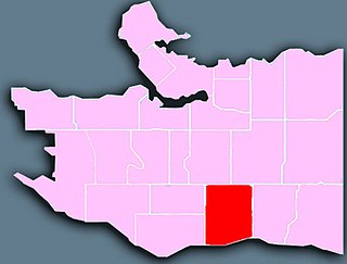
Shaughnessy is an almost-entirely residential neighbourhood in Vancouver, British Columbia, Canada, spanning about 447 hectares in a relatively central locale. It is bordered by 16th Avenue to the north, 41st Avenue to the south, Oak Street to the east, and East Boulevard to the west. The older section of the neighbourhood, called "First Shaughnessy," is considered more prestigious and is bordered by 16th Avenue to the north, King Edward Avenue to the south, Oak Street to the east, and East Boulevard to the west. In 2016, the population was approximately 8,810. It was named after Thomas Shaughnessy, 1st Baron Shaughnessy, former president of the Canadian Pacific Railway.

South Cambie is a neighbourhood in the city of Vancouver, British Columbia, Canada, that is generally considered one of the smallest neighbourhoods in the city, both in size and in population. It is wedged between one of the city's largest parks and the upscale neighbourhood of Shaughnessy, and is known for a large cluster of medical facilities.
Gambier Island is an island located in Howe Sound near Vancouver, British Columbia. It is about 17,049 acres in size and is located about 10 kilometres north of the Horseshoe Bay community and ferry terminal in westernmost West Vancouver.

The Dr. Sun Yat-Sen Classical Chinese Garden is the first Chinese or "scholars" garden built outside of China, and is located in Chinatown in Vancouver, British Columbia, Canada. It is located at 578 Carrall Street and consists of a freely accessible public park and a garden with an admission fee. The mandate of the garden is to "maintain and enhance the bridge of understanding between Chinese and western cultures, promote Chinese culture generally and be an integral part of the local community."

Victoria Harbour is a harbour, seaport, and seaplane airport in the Canadian city of Victoria, British Columbia. It serves as a cruise ship and ferry destination for tourists and visitors to the city and Vancouver Island. It is both a port of entry and an airport of entry for general aviation. Historically it was a shipbuilding and commercial fishing centre. While the Inner Harbour is fully within the City of Victoria, separating the city's downtown on its east side from the Victoria West neighbourhood, the Upper Harbour serves as the boundary between the City of Victoria and the district municipality of Esquimalt. The inner reaches are also bordered by the district of Saanich and the town of View Royal. Victoria is a federal "public harbour" as defined by Transport Canada. Several port facilities in the harbour are overseen and developed by the Greater Victoria Harbour Authority, however the harbour master's position is with Transport Canada.
Originally known as Capilano Estates, the British Properties is a residential area in West Vancouver, British Columbia, Canada. The 4,000 acre area was sold by the municipality of West Vancouver to the British Pacific Properties Corporation in 1931, which continues to develop the land to the present day.
Ambleside, West Vancouver, is a neighbourhood that occupies the southeastern corner of the community, with only Park Royal being farther east. The neighborhood is bordered by the neighbourhoods of Dundarave, Park Royal, and the British Properties. Ambleside overs the area from 19th Street to 13th Street, and from Fulton Avenue down to the waterfront. Marine Drive forms the centre of the community's commercial core, with two streets leading off from it.

Victoria West, commonly called Vic West, is an historic neighbourhood of the city of Victoria, British Columbia, Canada, located just west of downtown across Victoria Harbour, bordering on the Township of Esquimalt.
References
- ↑ "Nelson Park Community Garden expansion". City of Vancouver. Archived from the original on 2016-07-15. Retrieved 2016-08-13.
- ↑ "West End's Nelson Park waits for washroom". The Georgia Straight . 22 August 2012. Archived from the original on 2016-08-19. Retrieved 2016-08-13.
- ↑ "Nelson Park in Vancouver was paid for by developers through the various development fees charged by the city". The Vancouver Sun . Archived from the original on 2016-09-20. Retrieved 2016-08-13.