A dead end, also known as a cul-de-sac, no through road or no exit road, is a street with only one inlet or outlet.

The West End is a neighbourhood in Vancouver, British Columbia, Canada, located between the Coal Harbour neighbourhood and the financial and central business districts of Downtown Vancouver to the east, Stanley Park to the northwest, the English Bay to the west, and Kitsilano to the southwest across the False Creek opening.
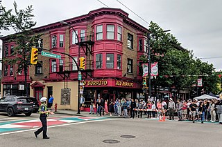
Commercial Drive is a roadway in the city of Vancouver in British Columbia, Canada, that extends from Powell Street at its northern extremity, near the waterfront, south through the heart of the Grandview–Woodland neighbourhood to the Victoria Diversion near Trout Lake. The neighbourhood is so dominated by the businesses, cultural facilities, and residents along Commercial Drive that the area is far better known as "The Drive" than by the civic boundaries. The district is one of Vancouver's Business Improvement Areas (BIA).

Wexford is a neighbourhood in Toronto, Ontario, Canada. It is located in the eastern part of the city, on the western end of the district of Scarborough, spanning Lawrence Avenue East between Victoria Park Avenue and Birchmount Road. There are many persons of Greek heritage in this neighbourhood. The Wexford Heights Business Improvement Area boasts 245 members and hosts an annual street festival on Lawrence.

The Vancouver School Board (VSB), officially the Board of Education of School District No. 39 (Vancouver), is a school district based in Vancouver, British Columbia, Canada. A board of nine elected trustees governs this school district that serves the city of Vancouver and the University Endowment Lands.

East Vancouver is a region within the city of Vancouver, British Columbia, Canada. Geographically, East Vancouver is bordered to the north by Burrard Inlet, to the south by the Fraser River, and to the east by the city of Burnaby. East Vancouver is divided from Vancouver's "West Side" by Ontario Street.

Killarney is a neighbourhood in East Vancouver, British Columbia with a population of over 28,000 in 2011 and lies in the far southeast corner of the city. It is on the south slope of the ridge that rises above the Fraser River, and contains a collection of single-family residences with a few multi-family homes as well as the townhouses and high-rises of the Fraserlands development along the river.

Victoria–Fraserview is a neighbourhood in the City of Vancouver, set on the south slope of the rise that runs north from the Fraser River and encompassing a large area of residential and commercial development. Surrounding the culturally eclectic Victoria Drive corridor, Victoria–Fraserview is an ethnically diverse area that was one of the earliest areas of settlement in the region.

Smithfield is a neighbourhood and former village in Toronto, Ontario, Canada. Some new residents of Toronto and new immigrants to Canada are attracted to this neighbourhood, mainly because there is a large amount of affordable public housing. It is named after the former village of Smithfield that was located at the intersection of Albion Road and Martin Grove Road. The neighbourhood is located north of the west branch of the Humber River and west of Kipling Avenue.

Clairlea is a safe, quiet, middle to upper-middle income neighbourhood in Toronto, Ontario, Canada that features well treed streets and detached homes with large backyards. The neighbourhood is located in east Toronto just east of Victoria Park Avenue.

Woburn is a neighbourhood located in eastern Toronto, Ontario, Canada, in the former suburb of Scarborough. Woburn is bordered by Highway 401 to the north, Orton Park Road to the east, Lawrence Avenue to the south, and McCowan Road to the west.
Killarney, also known as Killarney/Glengarry, is a residential neighbourhood in the city of Calgary, Alberta, Canada. It is bounded by 17th Avenue S.W. on the north, 37th Street S.W. on the west, Richmond Road S.W. on the south, and 25A Street S.W. on the east. It was named after Glengarry County, Ontario, as the place the first settlers originated from.

Greystone Heights is a mostly residential neighbourhood located in east-central Saskatoon, Saskatchewan, Canada. It is a suburban subdivision, consisting mostly of low-density, single detached dwellings and a sizeable minority of apartment-style multiple-unit dwellings. As of 2007, the area is home to 2,525 residents. The neighbourhood is considered a middle-income area, with an average family income of $58,811, an average dwelling value of $241,850 and a home ownership rate of 58.1%.
Varsity is an established neighbourhood in the Northwest quadrant of Calgary, Alberta. It was developed in the 1960s and early 1970s on a plateau to the north of the Bow River valley, and is primarily composed of Single-detached dwellings on wide lots. The neighbourhood comprises three major areas: Varsity Acres, Varsity Village, and Varsity Estates. Varsity is bounded on the north and east by Crowchild Trail, on the west by the Bow River, and on the south by 32nd Avenue NW. It borders the neighbourhoods of Silver Springs and Bowness on the west side, and both Montgomery and the University of Calgary campus on the south side. The easternmost portion of Varsity contains the University of Calgary Research Park.
Tuxedo Park is a residential neighbourhood in the northeast and northwest quadrants of Calgary, Alberta. The inner city community is bounded to the north by 32 Avenue N, by Edmonton Trail to the east, the Trans-Canada Highway to the south and 2 Street NW to the west. The community is bisected by Centre Street from north to south.
Saddle Ridge is a residential neighbourhood in the northeast quadrant of Calgary, Alberta. It is located at the northeastern edge of the city, and it is bounded to the north by Airport Trail NE, to the east by Stoney Trail NE, to the south by 80 Avenue NE and to the west by Métis Trail. The Saddle Ridge Industrial Area and Calgary International Airport are located west of the neighbourhood.

Princess Gardens is a neighbourhood in Toronto, Ontario, Canada. It is located in the western area of Toronto that was formerly the City of Etobicoke. Its boundaries are Eglinton Avenue to the north, Martin Grove to the west, Islington to the east, and Rathburn Road to the south. The southeastern part of this area is the separate neighbourhood of Thorncrest Village. The neighbourhood is divided into two areas: The portion east of Kipling Road is known as Princess Anne Manor, while the portion west of Kipling is Princess Margaret Gardens. They are named after Princess Anne, Princess Royal, and Princess Margaret, Countess of Snowdon, the daughter and sister of the late Queen Elizabeth II respectively. Both Princesses visited the Gardens and opened up Princess Margaret Public School during its opening ceremony. The southwestern part of the neighbourhood is also sometimes known as Glen Agar. Princess Gardens has some of the highest income Canadians in the Greater Toronto Area according to a 2016 census, at an average of $222,218 per year.

Willowgrove is a primarily residential neighbourhood located in the eastside of Saskatoon, Saskatchewan, Canada. It comprises a mix of mainly single-family detached houses and fewer multiple-unit dwellings. As of 2011, the area is home to 3,973 residents. The neighbourhood is considered a middle to high-income area, with an average family income of $96,002, an average dwelling value of $218,357 and a home ownership rate of 84.8%.

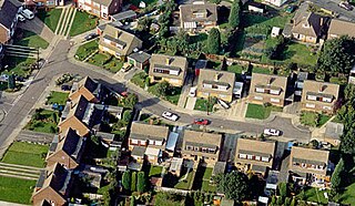
Everett Crowley Park is a 38-hectare large forested park with trails, located within the Champlain Heights area of Vancouver. The park was previously a landfill, but was allowed to become reforested for recreational purposes. Currently, it is Vancouver's 5th largest public park. The surrounding neighborhood was the last area to be developed in Vancouver in the 1970s. The park is maintained, developed, and protected by the Vancouver Park Board and stewarded by a committee of the Champlain Heights Community Association, the Everett Crowley Park Committee (ECPC). Many of the trails in the park are designated as dog off-leash areas. Everett Crowley Park is situated north of the Fraser River. It is a 3-minute walk north of Vancouver's developing River District, on the edge of the Fraser River.


