
Burnaby is a city in British Columbia, Canada, part of Metro Vancouver and immediately to the east of the City of Vancouver. It is the third-largest city in British Columbia by population, following Vancouver and nearby Surrey. Burnaby was incorporated in 1892 and achieved its City status in 1992, 100 years after incorporation. It is the seat of Metro Vancouver's regional government.

The Township of Langley is a district municipality immediately east of the City of Surrey in southwestern British Columbia, Canada. It extends south from the Fraser River to the U.S. border, and west of the City of Abbotsford. Langley Township is not to be confused with the City of Langley, which is adjacent to the township but politically is a separate entity. Langley is located in the eastern part of Metro Vancouver.

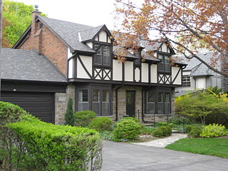
The Kingsway is an affluent residential neighbourhood in Etobicoke, Toronto, Ontario, Canada. It is bounded by Bloor Street to the south, Dundas Street to the north, the Mimico Creek to the west and the Humber River to the east. The neighbourhood was officially known as Kingsway Park, which later became replaced by its nickname, The Kingsway. For planning purposes, the neighbourhood is known by the City of Toronto as "Kingsway South" to differentiate it from a more recent extension of The Kingsway north of Dundas Street. "Kingsway South" is not used by residents, due to confusion with the South Kingsway, a street located east of the Humber River and extending south from Bloor Street.

Champlain Heights is a neighbourhood in the city of Vancouver, British Columbia, Canada.

Marpole, originally a Musqueam village named c̓əsnaʔəm, is a mostly residential neighbourhood of 23,832 in 2011, located on the southern edge of the city of Vancouver, British Columbia, immediately northeast of Vancouver International Airport. It is approximately bordered by Angus Drive to the west, 57th Avenue to the north, Fraser Street to the east and the Fraser River to the south. It has undergone many changes in the 20th century, with the influx of traffic and development associated with the construction of the Oak Street Bridge and the Arthur Laing Bridge.

Dunbar–Southlands is an affluent neighbourhood on the western side of Vancouver, British Columbia, Canada, that stretches north from the Fraser River and covers most between the mouth of the Fraser and English Bay. This neighbourhood consists of many commercial and residential areas that mostly consists of single-family dwellings. It also contains parts of the Mackenzie Heights enclave, and is the home territory of the Musqueam Indian Band.

East Vancouver is a region within the city of Vancouver, British Columbia, Canada. Geographically, East Vancouver is bordered to the north by Burrard Inlet, to the south by the Fraser River, and to the east by the city of Burnaby. East Vancouver is divided from Vancouver's "West Side" by Ontario St.

Victoria–Fraserview is a neighbourhood in the City of Vancouver, set on the south slope of the rise that runs north from the Fraser River and encompassing a large area of residential and commercial development. Surrounding the culturally eclectic Victoria Drive corridor, Victoria–Fraserview is an ethnically diverse area that was one of the earliest areas of settlement in the region.

Renfrew–Collingwood is a large neighbourhood that lies on the eastern side of Vancouver, British Columbia, Canada, on its boundary with Burnaby and encompassing an area that was one of the earlier developed regions of the city. It is a diverse area that includes a substantial business community in several areas, as well as some of the fastest-growing residential sectors of Vancouver. In 2011, the neighbourhood had a population of 50,500, 38.4% of whom claim Chinese as their first language.

Sutherland is a mostly residential neighbourhood located in east-central Saskatoon, Saskatchewan, Canada. It is an older suburban subdivision, composed of a near-even mix of single-family detached houses and multiple-unit apartment and semi-detached dwellings. As of 2006, the area was home to 5,206 residents. The neighbourhood is a middle-income area, with an average family income of $51,857, an average dwelling value of $204,213 and a home ownership rate of 43.8%. According to MLS data, the average sale price of a home as of 2013 was $288,651. Sutherland was administered as a separate town outside of Saskatoon before being annexed by the city in 1956.
Humber Valley Village is a neighbourhood located in Toronto, Ontario, Canada. It is within the former City of Etobicoke and is a relatively affluent community. The boundaries are from Dundas Street on the south to Islington Avenue to the west, Eglinton Avenue to the north, and the Humber River in the east. The neighbourhood is in the political riding of Etobicoke Centre.
North Burnaby is a general name for a large neighbourhood in the City of Burnaby, British Columbia, that includes a number of smaller ones. It stretches from Boundary Road in the west to Burnaby Mountain with Simon Fraser University in the east and bounded by Burrard Inlet to the north and the Lougheed Highway to the south. It is a desirable place to live for many local and immigrant families which is reflected by real-estate prices that keep climbing and have doubled in the last 15 years.
Windsor, Ontario has a very diverse population, and this diversity is shown in its many neighbourhoods. Windsor has twenty in all, ranging from rural farmland to densely built-up areas.

Main Street is a major north–south thoroughfare bisecting Vancouver, British Columbia, Canada. It runs from Waterfront Road by Burrard Inlet in the north, to Kent Avenue alongside the north arm of the Fraser River in the south.
Forest Grove is a primarily residential neighbourhood located in northeast Saskatoon, Saskatchewan, Canada. It is mostly made up of low-density single detached dwellings, with a sizeable minority of multiple-unit apartment dwellings. As of 2011, the area is home to 5,907 residents. The neighbourhood is considered a middle-income area, with an average family income of $70,487, an average dwelling value of $246,680 and a home ownership rate of 62.4%. According to MLS data, the average sale price of a home as of 2013 was $304,527.
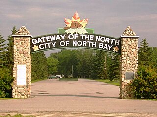
The Canadian city of North Bay, Ontario, is divided into numerous neighbourhoods.
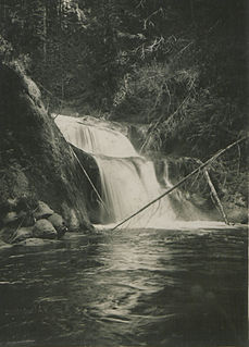
Kanaka Creek Regional Park is a regional park of the Greater Vancouver Regional District, located in the District of Maple Ridge, British Columbia, flanking both sides of Kanaka Creek from its confluence with the Fraser River just east of Haney and extending approximately 11 km up the creek to just south of the community of Webster's Corners.

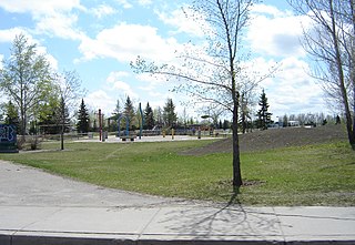
Everett Crowley Park is a 38-hectare large forested park with trails, located within the Champlain Heights area of Vancouver. The park was previously a landfill, but was allowed to become reforested recreational purposes. Currently, it is Vancouver's 5th largest public park. The surrounding neighborhood was the last area to be developed in Vancouver in the 1970s. The park is maintained, developed, and protected by the Vancouver Park Board and stewarded by a committee of the Champlain Heights Community Association, the Everett Crowley Park Committee (ECPC). Many of the trails in the park are designated as dog off-leash areas. Everett Crowley Park is situated north of the Fraser River. It is a 3-minute walk north of Vancouver's developing River District, on the edge of the Fraser River.


