This article needs additional citations for verification .(May 2022) |
South Granville | |
---|---|
Neighbourhood | |
Country | Canada |
Province | British Columbia |
City | Vancouver |
Location | Fairview (West Side) |
Time zone | UTC-8 (PST) |
• Summer (DST) | UTC-7 (EDT) |
Website | www |
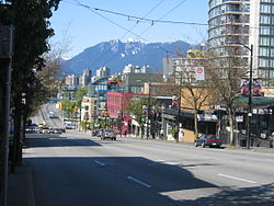
Established in 1997, South Granville (or less commonly "Uptown") is an upscale Business Improvement Area (BIA) and neighbourhood south of Vancouver's downtown core, centred along Granville Street and bordered by the neighbourhoods of Kitsilano, Fairview and Shaughnessy.
Separated from Downtown by False Creek, the area runs along Granville Street from the south side of the Granville Street Bridge up to 16th Ave, where storefronts are replaced by the residences and hedges of Shaughnessy.
1907 has been decided as the unofficial birth year of the neighbourhood. In that year Richard Marpole drew up plans for Shaughnessy Heights, the Canadian Pacific Railway's newest subdivision south of 16th Ave, pitched as an alternative to the then-upscale West End ("Blueblood Alley"). This is now known as "First Shaughnessy", or simply Shaughnessy. That same year, what was once Centre Street was given its present name, Granville Street, as the portion north of the bridge already bore that name. In 2007, the South Granville BIA commemorated the neighbourhood's centennial by encasing a state-of-the-art, stainless steel time capsule in concrete and stone under the entrance of the historic Stanley Theatre.
As well as being a fast-growing neighbourhood of residences, shops and restaurants, South Granville is home to a vibrant arts and culture scene. The neighbourhood contains a strip, between Broadway and the foot of the Granville Bridge, known as "Gallery Row" which is home to a number of art galleries: Bau-Xi Gallery, Douglas Reynolds Gallery, Ian Tan Gallery, Petley Jones Gallery, Uno Langmann. The South Granville Gallery Association (SGGA) represents the leading fine art galleries on Gallery Row. [1] Further south, the neighbourhood is home to the historic Stanley Theatre, built in 1931. Once a popular cinema in its early days, the Stanley Theatre is now the stage of the Arts Club Theatre Company and the Industrial Alliance Stage.
Granville Island is a peninsula and shopping district in the Fairview neighbourhood of Vancouver, British Columbia, Canada, across False Creek from Downtown Vancouver, under the south end of the Granville Street Bridge. Formerly an industrial manufacturing area, it was named after Granville Leveson-Gower, 2nd Earl Granville.
The West End is a neighbourhood in Vancouver, British Columbia, Canada, located between the Coal Harbour neighbourhood and the financial and central business districts of Downtown Vancouver to the east, Stanley Park to the northwest, the English Bay to the west, and Kitsilano to the southwest across the False Creek opening.
Queen Street is a major east–west thoroughfare in Toronto, Ontario, Canada. It extends from Roncesvalles Avenue and King Street in the west to Victoria Park Avenue in the east. Queen Street was the cartographic baseline for the original east–west avenues of Toronto's and York County's grid pattern of major roads. The western section of Queen is a centre for Canadian broadcasting, music, fashion, performance, and the visual arts. Over the past twenty-five years, Queen West has become an international arts centre and a tourist attraction in Toronto.
The Orpheum is a theatre and music venue in Vancouver, British Columbia, Canada. Along with the Queen Elizabeth Theatre, the Vancouver Playhouse, and the Annex, it is part of the Vancouver Civic Theatres group of live performance venues. It is the permanent home of the Vancouver Symphony Orchestra. The Orpheum is located on Granville Street near Smithe Street in Vancouver's downtown core. The interior of the theatre was featured in the 2004 reboot of Battlestar Galactica, where it is dressed to portray a heavenly opera house.
Downtown Calgary is a dense urban district in central Calgary, Alberta. It contains the second largest concentration of head offices in Canada, despite only being the country's fourth largest city in terms of population. The downtown is divided into several residential, commercial, corporate, and mixed-use neighbourhoods, including the Financial District (CBD), Eau Claire, Chinatown, East Village, Beltline, and the West End.
Granville Street is a major street in Vancouver, British Columbia, Canada, and part of Highway 99. Granville Street is most often associated with the Granville Entertainment District and the Granville Mall. This street also cuts through residential neighbourhoods like Shaughnessy and Marpole via the Granville Street Bridge.
Downtown Halifax is the primary central business district of the Municipality of Halifax. Located on the central-eastern portion of the Halifax Peninsula, on Halifax Harbour. Along with Downtown Dartmouth, and other de facto central business districts within the Municipality, Downtown Halifax serves as the business, entertainment, and tourism hub of the region.
Marda Loop is a shopping and dining district in southwest Calgary, Alberta, Canada. While the name "Marda Loop" originated with the BIA, it also applies generically to the surrounding community and to the residential Marda Loop Communities Association. This entry is primarily about the Marda Loop BIA.
Downtown Vancouver is the central business district and the city centre neighbourhood of Vancouver, Canada, on the northwestern shore of the Burrard Peninsula in the Lower Mainland region of British Columbia. It occupies most of the north shore of the False Creek inlet, which cuts into the Burrard Peninsula creating the Downtown Peninsula, where the West End neighbourhood and Stanley Park are also located.
South Cambie is a neighbourhood in the city of Vancouver, British Columbia, Canada, that is generally considered one of the smallest neighbourhoods in the city, both in size and in population. It is wedged between one of the city's largest parks and the upscale neighbourhood of Shaughnessy, and is known for a large cluster of medical facilities.
The City of Oklahoma City uses Special Zoning Districts as a tool to maintain the character of many neighborhood communities.
Midtown is one of four central business districts outside the city's downtown core of Toronto, Ontario, Canada. Located in the north of Old Toronto, its borders are roughly defined by St. Clair Avenue to the south and Eglinton Avenue or Lawrence Avenue to the north, Bayview Avenue to the east and Dufferin Street to the west. The central neighbourhood of the area is Yonge–Eglinton.
Georgia Street is an east–west street in the cities of Vancouver and Burnaby, British Columbia, Canada. Its section in Downtown Vancouver, designated West Georgia Street, serves as one of the primary streets for the financial and central business districts, and is the major transportation corridor connecting downtown Vancouver with the North Shore by way of the Lions Gate Bridge. The remainder of the street, known as East Georgia Street between Main Street and Boundary Road and simply Georgia Street within Burnaby, is more residential in character, and is discontinuous at several points.
Downtown is the central business district of Washington, D.C., located in Northwest D.C. It is the third largest central business district in the United States. The "Traditional Downtown" has been defined as an area roughly between Union Station in the east and 16th Street NW in the west, and between the National Mall on the south and Massachusetts Avenue on the north, including Penn Quarter. However, nowadays, Downtown D.C. can often refer to a larger area, as the DC Office of Planning states:
…most residents, workers, and visitors think of Downtown in a broader sense — including areas as far north as Dupont Circle, as far west as Foggy Bottom, and as far east as Capitol Hill. Only about half of the central city workforce is located within the city’s traditional Downtown.
Nutana is a primarily residential neighbourhood located near the centre of Saskatoon, Saskatchewan, Canada. It includes the business district of Broadway Avenue. It comprises a nearly even mixture of low-density, single detached dwellings and apartment-style multiple unit dwellings. As of 2009, the area is home to 6,261 residents. The neighbourhood is considered a middle to upper-income area, with an average family income of $67,657, an average dwelling value of $206,830 and a home ownership rate of 51.3%. First established in 1883, Nutana was the original settlement of what now makes up the city of Saskatoon.
This is a list of neighbourhoods in the urban core of Greater Sudbury, Ontario. This list includes only those neighbourhoods that fall within the pre-2001 city limits of Sudbury — for communities within the former suburban municipalities, see the articles Capreol, Nickel Centre, Onaping Falls, Rayside-Balfour, Valley East and Walden.
Downtown Oklahoma City is located at the geographic center of the Oklahoma City metropolitan area and contains the principal, central business district of the region. Downtown has over 80,000 workers and over 13,310,000 sq ft (1,237,000 m2) of leasable office space to-date. Downtown Oklahoma City is the legal, financial, economic, nightlife, and entertainment center of the region.
Rockland is a historic neighbourhood of Victoria, British Columbia, Canada, located just southeast of downtown and northeast of Beacon Hill Park, and comprising the northern portion of the official city neighbourhood of Fairfield. Its boundaries are imprecise but the area roughly flanks Rockland Avenue.
The R4 41st Ave is an express bus route with bus rapid transit elements in Metro Vancouver, British Columbia, Canada. Part of TransLink's RapidBus network, it replaced the 43 Express that travelled along 41st Avenue, a major east–west route that connects the University of British Columbia (UBC) to the SkyTrain system's Oakridge–41st Avenue station on the Canada Line and Joyce–Collingwood station on the Expo Line.