Burrard Street

Last updated
Burrard Street
Burrard St.JPG
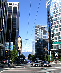
Burrard Street in the Financial District, with a vista of the North Shore Mountains.
Namesake Burrard Inlet, Sir Harry Burrard-Neale
TypeStreet
Length4.6 km [1] (2.9 mi)
LocationFinancial District, central
Nearest metro station Burrard Station
North end Canada Place
Major
junctions
Hastings Street
Georgia Street
Robson Street
Broadway
South endWest 17th Avenue
Burrard Street entrance to St. Paul's Hospital Vancouver - St Paul's Hospital pano 01.jpg
Burrard Street entrance to St. Paul's Hospital
Vancouver Financial District, with '666 Burrard Street' landmark skyscraper (foreground) and the Bentall 5 tower (left), circa 2006. 666 Burrard.JPG
Vancouver Financial District, with '666 Burrard Street' landmark skyscraper (foreground) and the Bentall 5 tower (left), circa 2006.

Burrard Street is a major thoroughfare in Vancouver, British Columbia, Canada. It is the central street of Downtown Vancouver and the Financial District. [ citation needed ] The street is named for Burrard Inlet, located at its northern terminus, which in turn is named for Sir Harry Burrard-Neale. [2]

Contents

The street starts at Canada Place near the Burrard Inlet, then runs southwest through downtown Vancouver. It crosses False Creek via the Burrard Bridge. South of False Creek, on what used to be called Cedar Street before the completion of the bridge in 1932, [3] the street runs due south until the intersection with West 16th Avenue.

The intersection of Burrard Street and Georgia Street is considered to be the centrepoint of Downtown Vancouver, along with the more tourist-oriented and upscale shopping-spirited intersection of Burrard Street and Robson Street to the south. At and due northeast of the centre is the heart of the Financial District. Further down closer to Vancouver Harbour stands the historic Marine Building, an Art Deco masterpiece, opened in 1930, two years before the Art Deco pylons of the Burrard Bridge at the opposite end of the street. Finally at the Harbour lies Canada Place and the Vancouver Convention Centre.

Nearer to Burrard Bridge is located St. Paul's Hospital, established on Burrard Street in 1894.

Burrard Street served as the dividing line between the two district lots laid out on the downtown peninsula in the second half of the 19th century: District Lot 185 (now West End) and District Lot 541 (granted to the Canadian Pacific Railway). [4] The two grids were oriented differently, with the result that only every third northwest-southeast street in DL185 actually continuing southeast beyond Burrard into DL541. Burrard currently serves as the boundary between West End and Downtown, as defined by the City of Vancouver. [5]

Burrard Street is served by SkyTrain's Burrard Station, located underground between the intersections with Melville and Dunsmuir Streets in the heart of the Financial District. Along the downtown portion, there is a bike lane on the southwest-bound direction towards the Burrard Bridge.

Major intersections

The entire route is in Vancouver.

km [1] miDestinationsNotes
0.00.0 Canada Place
0.10.062Cordova Street
0.20.12 Hastings Street
0.30.19Pender Street
0.40.25Dunsmuir Street
0.60.37BC-99.svg Georgia Street (Hwy 99)
0.80.50 Robson Street
0.90.56Smithe StreetOne-way, northwest-bound (east of Burrard Street)
1.10.68Nelson StreetOne-way, southeast-bound; connects to Cambie Street Bridge and Cambie Street
1.40.87 Davie Street
1.71.1Pacific Street
1.8–
2.7
1.1–
1.7
Burrard Street Bridge crosses False Creek
2.81.7Cornwall Avenue
3.32.1West 4th Avenue
3.82.4 Broadway
4.52.8West 16th Avenue
4.62.9Cedar Crescent / West 17th Avenue
1.000 mi = 1.609 km; 1.000 km = 0.621 mi

Related Research Articles

Gastown Neighbourhood in Vancouver, British Columbia, Canada

Gastown, the original settlement that became the core of the city of Vancouver, British Columbia, Canada, is a national historic site and a neighbourhood in the northwest section of the Downtown Eastside, adjacent to Downtown Vancouver.

Granville Island

Granville Island is a peninsula and shopping district in Vancouver, British Columbia, Canada. It is located across False Creek from Downtown Vancouver under the south end of the Granville Street Bridge. The peninsula was once an industrial manufacturing area, but today it is a hotspot for Vancouver tourism and entertainment. Some Vancouver based tour companies, such as Discover Vancouver Tours and Vancity Tours, offer stops at Granville Island. The area was named after Granville Leveson-Gower, 2nd Earl Granville.

West End, Vancouver Neighbourhood of Vancouver in British Columbia, Canada

The West End is a neighbourhood in Vancouver, British Columbia, Canada, located between the Coal Harbour neighbourhood and the financial and central business districts of Downtown Vancouver to the east, Stanley Park to the northwest, the English Bay to the west, and Kitsilano to the southwest across the False Creek opening.

Highway 7A, known locally and on street signs as the Barnet Highway and Hastings Street, was Highway 7's original 1941 route between the harbour in Vancouver and Port Moody. The highway gained the 7A designation in 1953 and was disestablished in 2006.

Cambie Street

Cambie Street is a street in Vancouver, British Columbia, Canada. It is named for Henry John Cambie, chief surveyor of the Canadian Pacific Railway's western division.

Robson Street

Robson Street is a major southeast-northwest thoroughfare in downtown and West End of Vancouver, British Columbia, Canada. Its core commercial blocks from Burrard Street to Jervis were also known as Robsonstrasse. Its name honours John Robson, a major figure in British Columbia's entry into the Canadian Confederation, and Premier of the province from 1889 to 1892. Robson Street starts at BC Place Stadium near the north shore of False Creek, then runs northwest past Vancouver Library Square, Robson Square and the Vancouver Art Gallery, coming to an end at Lost Lagoon in Stanley Park.

Kitsilano Neighbourhood of Vancouver in British Columbia, Canada

Kitsilano is a neighbourhood located in the city of Vancouver, British Columbia, Canada. Kitsilano is named after Squamish Chief August Jack Khatsahlano, and the neighbourhood is located in Vancouver's West Side along the south shore of English Bay, between the neighbourhoods of West Point Grey and Fairview.

Burrard Inlet coastal fjord in southwestern British Columbia

Burrard Inlet is a relatively shallow-sided fjord in northwestern Lower Mainland, British Columbia, Canada. Formed during the last Ice Age, it separates the City of Vancouver and the rest of the lowland Burrard Peninsula to the south from the coastal slopes of the North Shore Mountains which span West Vancouver and the City and District of North Vancouver to the north.

Burrard Peninsula

The Burrard Peninsula is a peninsula in the Lower Mainland region of British Columbia, Canada, bounded by the Burrard Inlet to the north, the Georgia Strait to the west, the North Arm of Fraser River to the south, and the Pitt River and Douglas Island to the east. The City of Vancouver occupies almost all of the western half of the peninsula, and the Cities of Burnaby and New Westminster occupy more than half of the eastern half. At its northeastern end, the peninsula is connected to the Eagle Mountain and Mount Burke of the Coast Mountains via a small isthmus at the center of the Tri-Cities.

False Creek Inlet in Vancouver, British Columbia, Canada

False Creek is a short narrow inlet in the heart of Vancouver, separating the Downtown and West End neighbourhoods from the rest of the city. It is one of the four main bodies of water bordering Vancouver, along with English Bay, Burrard Inlet and the Fraser River. Granville Island is located within the inlet.

Coal Harbour Neighbourhood in Vancouver, British Columbia, Canada

Coal Harbour is the name for a section of Burrard Inlet lying between Vancouver's Downtown Peninsula and the Brockton Point of Stanley Park. It has also now become the name of the neighbourhood adjacent to its southern shoreline.

Burrard Bridge

The Burrard Street Bridge is a four-lane, Art Deco style, steel truss bridge constructed in 1930–1932 in Vancouver, British Columbia, Canada. The high, five part bridge on four piers spans False Creek, connecting downtown Vancouver with Kitsilano via connections to Burrard Street on both ends. It is one of three bridges crossing False Creek. The other two bridges are the Granville Bridge, three blocks or 0.5 km (0.31 mi) to the southeast, and the Cambie Street Bridge, about 11 blocks or 2 km (1.2 mi) to the east. In addition to the vehicle deck, the Burrard Bridge has 2.6 m wide sidewalks and a dedicated cycling lane on both sides.

Downtown Vancouver Neighbourhood of Vancouver in British Columbia, Canada

Downtown Vancouver is the main central business district and the city center neighbourhood of Metro Vancouver, located on the northwestern shore of the Burrard Peninsula in the Lower Mainland region of British Columbia. The Downtown occupies most of the north shore of the False Creek inlet, which incises into the Burrard Peninsula creating the namesaked Downtown Peninsula, where the West End neighbourhood and Stanley Park are also located.

Transportation in Vancouver

Transportation in Vancouver, British Columbia has many of the features of modern cities worldwide. Unlike many large metropolises, Vancouver has no freeways into or through the downtown area. A proposed freeway through the downtown was rejected in the 1960s by a coalition of citizens, community leaders and planners. This event "signalled the emergence of a new concept of the urban landscape" and has been a consistent element of the city's planning ever since.

Knight Street

Knight Street is a major north-south roadway in Vancouver and Richmond, British Columbia, Canada. It is a four-to-six lane freeway from Westminster Highway in Richmond to Marine Drive in Vancouver, thus serving as an alternate way to exit Vancouver southbound, rather than the Granville Street/Oak Street corridor. Upon entering Vancouver, Knight Street provides major access routes to East Vancouver; at 14th Avenue, the road turns into Clark Drive, and runs northbound until it reaches the Port of Vancouver at Burrard Inlet. It is the busiest truck route in Vancouver, and a key link between Vancouver and its neighbours to the south.

Georgia Street

Georgia Street is an east–west street in the cities of Vancouver and Burnaby, British Columbia, Canada. Its section in Downtown Vancouver, designated West Georgia Street, serves as one of the primary streets for the financial and central business districts, and is the major transportation corridor connecting downtown Vancouver with the North Shore by way of the Lions Gate Bridge. The remainder of the street, known as East Georgia Street between Main Street and Boundary Road and simply Georgia Street within Burnaby, is more residential in character, and is discontinuous at several points.

Main Street (Vancouver) Major road in Vancouver, British Columbia

Main Street is a major north–south thoroughfare bisecting Vancouver, British Columbia, Canada. It runs from Waterfront Road by Burrard Inlet in the north, to Kent Avenue alongside the north arm of the Fraser River in the south.

Broadway (Vancouver) Thoroughfare in Vancouver, British Columbia

Broadway is a major east–west thoroughfare in the city of Vancouver, British Columbia, Canada. In Vancouver's numbered avenue grid system, it runs in place of a 9th Avenue, between 8th and 10th. The street has six lanes for most of its course. Portions of the street carry the British Columbia Highway 7 designation.

Marine Drive is the name for three major roadways in Greater Vancouver, British Columbia, Canada. The roads are known for running parallel to major bodies of water, with some sections being a major arterial road, while other serve local traffic. Marine Way is the name applied to a section of Marine Drive that was bypassed in the early 1980s.

References

  1. 1 2 Google (October 13, 2021). "Burrard Street, Vancouver" (Map). Google Maps . Google. Retrieved October 13, 2021.
  2. Snyders, Tom; Jennifer O'Rourke (2002). Namely Vancouver: A Hidden History of Vancouver Place Names. Arsenal Pulp Press. p. 51. ISBN   978-1-55152-077-3.
  3. History of Vancouver - Burrard Bridge
  4. Berelowitz, Lance (2010). Dream City: Vancouver and the Global Imagination. Douglas & McIntyre. p. 44. ISBN   978-1-55365-170-3.
  5. Vancouver - communityWEBpages - West End

Route map:

KML file (edithelp)
    KML is from Wikidata