
New Westminster is a city in the Lower Mainland region of British Columbia, Canada, and a member municipality of Metro Vancouver. It was founded by Major-General Richard Moody as the capital of the new-born Colony of British Columbia in 1858, and continued in that role until the Mainland and Island Colonies were merged in 1866, and was the Mainland's largest city from that year until it was passed in population by Vancouver during the first decade of the 20th century.

Gastown is the original settlement that became the core of the creation of Vancouver, British Columbia, Canada. Currently, it is a national historic site and a neighbourhood in the northwest end of Downtown Eastside, adjacent to Downtown Vancouver.

Davie Village is a neighbourhood in the West End of Vancouver, British Columbia, Canada. It is the home of the city's gay subculture, and, as such, is often considered a gay village, or gaybourhood. Davie Village is centred on Davie Street and roughly includes the area between Burrard and Jervis streets. Davie Street—and, by extension, the Village—is named in honour of A.E.B. Davie, eighth Premier of British Columbia from 1887 to 1889; A.E.B's brother Theodore was also Premier, from 1892 to 1895.
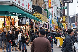
Canal Street is a major east–west street in Lower Manhattan, New York City, running from East Broadway between Essex and Jefferson Streets in the east, to West Street between Watts and Spring Streets in the west. It runs through the neighborhood of Chinatown, and forms the southern boundaries of SoHo and Little Italy as well as the northern boundary of Tribeca. The street acts as a major connector between Jersey City, New Jersey, via the Holland Tunnel (I-78), and Brooklyn in New York City via the Manhattan Bridge. It is a two-way street for most of its length, with two unidirectional stretches between Forsyth Street and the Manhattan Bridge.

Cambie Street is a street in Vancouver, British Columbia, Canada. It is named for Henry John Cambie, chief surveyor of the Canadian Pacific Railway's western division.
Marshall Field's was a department store in Chicago, Illinois, founded in the 19th century that grew to become a large chain before being acquired by Macy's, Inc in 2005.
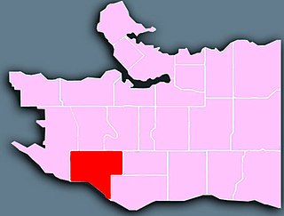
Kerrisdale is a neighbourhood in the city of Vancouver, British Columbia, Canada.

The Punjabi Market, also known as Little India, is a commercial district and ethnic enclave in Vancouver, British Columbia. Officially recognized by the city as being primarily a major South Asian and Indo-Canadian business community and cultural area, the Punjabi District is roughly a six block section of Main Street around 49th Avenue in the Sunset neighbourhood.

Sadar Bazaar, also written as Sadr/Saddar Bazaar, is the largest wholesale market of household items in Delhi, India.

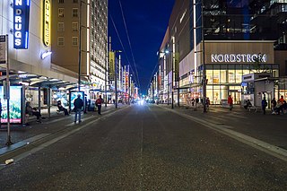
Burrard Street is a major thoroughfare in Vancouver, British Columbia, Canada. It is the central street of Downtown Vancouver and the Financial District. The street is named for Burrard Inlet, located at its northern terminus, which in turn is named for Sir Harry Burrard-Neale.
Granville Street is a major street in Vancouver, British Columbia, Canada, and part of Highway 99. Granville Street is most often associated with the Granville Entertainment District and the Granville Mall. This street also cuts through residential neighbourhoods like Shaughnessy and Marpole via the Granville Street Bridge.
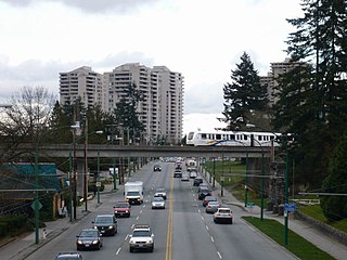
Kingsway is a major thoroughfare that crosses through the Canadian cities of Vancouver and Burnaby, British Columbia. The road runs diagonally from northwest to southeast, emerging from Vancouver's Main Street just south of East 7th Avenue and becoming 12th Street at the Burnaby–New Westminster border.

The Wholesale District or Warehouse District in Downtown Los Angeles, California, has no exact boundaries, but at present it lies along the BNSF and Union Pacific Railroad lines, which run parallel with Alameda Street and the Los Angeles River. Except for some ancillary commercial uses, its cityscape is mostly occupied by warehouses and refrigerated storage facilities. This area is known as Central City North in the Los Angeles city zoning map.

The Wholesale District is one of six designated cultural districts in Indianapolis, Indiana. Located on in the southern section of Downtown Indianapolis' Mile Square, the Wholesale District contains several notable attractions, such as Bankers Life Fieldhouse, Circle Centre Mall, and the Soldiers' and Sailors' Monument.

Knight Street is a major north-south roadway in Vancouver and Richmond, British Columbia, Canada. It is a four-to-six lane freeway from Westminster Highway in Richmond to Marine Drive in Vancouver, thus serving as an alternate way to exit Vancouver southbound, rather than the Granville Street/Oak Street corridor. Upon entering Vancouver, Knight Street provides major access routes to East Vancouver; at 14th Avenue, the road turns into Clark Drive, and runs northbound until it reaches the Port of Vancouver at Burrard Inlet. It is the busiest truck route in Vancouver, and a key link between Vancouver and its neighbours to the south.

Georgia Street is an east–west street in the cities of Vancouver and Burnaby, British Columbia, Canada. Its section in Downtown Vancouver, designated West Georgia Street, serves as one of the primary streets for the financial and central business districts, and is the major transportation corridor connecting downtown Vancouver with the North Shore by way of the Lions Gate Bridge. The remainder of the street, known as East Georgia Street between Main Street and Boundary Road and simply Georgia Street within Burnaby, is more residential in character, and is discontinuous at several points.

Hastings Street is one of the most important east-west traffic corridors in the cities of Vancouver and Burnaby, British Columbia, Canada, and used to be a part of the decommissioned Highway 7A. In the central business district of Downtown Vancouver it is known as West Hastings Street; at Carrall Street it becomes East Hastings Street and runs eastwards through East Vancouver and Burnaby. In Burnaby, there is no east-west designation. The street ends in Westridge, a neighbourhood at the foot of Burnaby Mountain where it joins the recently built Burnaby Mountain Parkway and diverges from the continuation of the former Highway 7A as the Barnet Highway, to Port Moody, British Columbia.

Main Street is a major north–south thoroughfare bisecting Vancouver, British Columbia, Canada. It runs from Waterfront Road by Burrard Inlet in the north, to Kent Avenue alongside the north arm of the Fraser River in the south.

Oak Street is a major north-south street in Vancouver, British Columbia, Canada. The street begins in the north at an intersection with 6th Avenue in the Fairview neighbourhood and continues to the Oak Street Bridge in the south, leading towards Richmond. There is a small portion west of the bridge that is in the industrial area of Vancouver along the Fraser River From its intersection with 70th Avenue southwards, the route is a component section of Highway 99, except for the aforementioned industrial section.
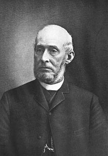
Cicero Hunt Lewis (1826–1897) was a prominent merchant and investor in Portland in the U.S. state of Oregon during the second half of the 19th century. Born in New Jersey, Lewis and a friend, Lucius Allen, traveled across the continent in 1851 to open a dry goods and grocery store in what was then a frontier town of about 800 people living along the west bank of the Willamette River. By 1880, their firm, Allen & Lewis, had become one of the leading wholesale grocery companies on the West Coast.
