
The Trans-Canada Highway is a transcontinental federal–provincial highway system that travels through all ten provinces of Canada, from the Pacific Ocean on the west coast to the Atlantic Ocean on the east coast. The main route spans 7,476 km (4,645 mi) across the country, one of the longest routes of its type in the world. The highway system is recognizable by its distinctive white-on-green maple leaf route markers, although there are small variations in the markers in some provinces.

The Township of Langley is a district municipality immediately east of the City of Surrey in southwestern British Columbia, Canada. It extends south from the Fraser River to the U.S. border, and west of the City of Abbotsford. Langley Township is not to be confused with the City of Langley, which is adjacent to the township but politically is a separate entity. Langley is located in the eastern part of Metro Vancouver.
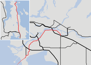
Highway 1 is the main route of the Trans-Canada Highway (TCH) through British Columbia, Canada. Its total accumulated distance through British Columbia is 1,039 km (646 mi), including the distance travelled on ferries. It is the westernmost portion of the "Highway 1" designation of the TCH through Western Canada, which extends to the Manitoba–Ontario boundary. The section of Highway 1 in the Lower Mainland is the second-busiest freeway in Canada, after the section of Ontario Highway 401 in Toronto.
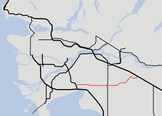
Highway 17 is a provincial highway in British Columbia, Canada. It comprises two separate sections connected by a ferry link. The Vancouver Island section is known as the Patricia Bay Highway and connects Victoria to the Swartz Bay ferry terminal in North Saanich. The Lower Mainland section is known as the South Fraser Perimeter Road and connects the Tsawwassen ferry terminal to Delta and Surrey, terminating at an interchange with Highway 1 in the Fraser Valley.
Highway 10 is a minor east-west route through the southern portion of Greater Vancouver. Highway 10 is used mainly as a local access route in North Delta, Surrey and Langley, its former connector role between South Delta and Highway 1 having been taken over by the Highway 17.
There are many roads in the southwestern part of British Columbia and Vancouver Island that were designated as Highway 1A. These roads were sections of the original 1941 route of Highway 1 before its various re-alignments, and are used today as service routes and frontage roads. The "B.C. Highway 1A" designations were removed from these sections by the province between 2005 and 2010, although signage remains along some of the route and the designation on some maps.

Highway 13 is an 11.5 km (7.1 mi) long two-lane route through the eastern part of Langley, British Columbia. Highway 13 connects Washington state to the central Fraser Valley.

Highway 7B, known as the Mary Hill Bypass, is a 7.27 km (4.52 mi) long riverside east-west link between the cities of Coquitlam to the west and Port Coquitlam to the east. The Mary Hill Bypass gained its numbered designation in 1996, when it was widened from two to four lanes north of Broadway. Highway 7B meets Highway 7 at both of its ends, and also links to Highway 1 within Coquitlam at the Cape Horn Interchange.
Highway 97 is a major highway in the Canadian province of British Columbia. It is the longest continuously numbered route in the province, running 2,081 km (1,293 mi) and is the only route that runs the entire north–south length of the British Columbia, connecting the Canada–United States border near Osoyoos in the south to the British Columbia–Yukon boundary in the north at Watson Lake, Yukon.

The City of Langley, commonly referred to as Langley City, or just Langley, is a municipality in the Metro Vancouver Regional District in British Columbia, Canada. It lies directly east of Surrey, adjacent to the Cloverdale area, and is surrounded elsewhere by the Township of Langley, bordered by its neighbourhoods of Willowbrook to the north, Murrayville to the east, and Brookswood and Fern Ridge to the south.

The K-class ferries are a group of similarly designed ferries operated by both BC Ferries and TransLink in British Columbia, Canada.

Fort Langley is a village community in Township of Langley, British Columbia, Canada. It has a population of approximately 3,400 people. It is the home of Fort Langley National Historic Site, a former fur trade post of the Hudson's Bay Company. Lying on the Fraser River, Fort Langley is at the northern edge of the Township of Langley.

Fraser Highway is a 38-kilometre-long (24 mi) major arterial road in the Lower Mainland of British Columbia. Connecting the cities of Surrey and Abbotsford, the highway formerly constituted a major portion of British Columbia Highway 1A until the latter was decommissioned in 2006. The highway is named for the Fraser River and the Fraser Valley, which are in turn named for the explorer Simon Fraser.

State Route 539 is a north–south state highway in the U.S. state of Washington. The highway travels through northwestern Whatcom County and connects Interstate 5 (I-5) in Bellingham with Lynden and the Canadian border near Langley, British Columbia.
Kwantlen First Nation is a First Nations band government in British Columbia, Canada, located primarily on McMillan Island near Fort Langley. The Kwantlen people traditionally speak hən̓q̓əmin̓əm̓, the Downriver dialect of Halkomelem, one of the Salishan family of languages.
McMillan Island is an island in the Fraser River, British Columbia, Canada, also known as McMillan Slough..
Albion, British Columbia is a neighbourhood in Maple Ridge, British Columbia and is one of several small towns incorporated within the municipality at its creation. It is the oldest non-indigenous community of the district's settlements, and is only slightly younger than Fort Langley, adjacent across the Fraser River, and Kanaka Creek, which is just to the west and lies along the creek of the same name. Its official definition is the area bounded by the Fraser River, Kanaka Way, and 240th Street, but in its historic sense it means the community centred on and flanking 240th Street and adjoining areas along the Fraser River waterfront and around the Maple Ridge Fairgrounds, while along Kanaka Way and also on the near bank of Kanaka Creek, the creek, is historically the community of Kanaka Creek. Burgeoning newer home construction east of 240th Street near the Lougheed Highway is also often referred to as part of Albion.

The Old Yale Road is a historic early wagon road between New Westminster, British Columbia, Canada and Yale, British Columbia, and servicing the Fraser Valley of the British Columbia Lower Mainland in the late 19th century and into the early 20th. It eventually became an early highway route for automobiles through the valley and into the British Columbia interior beyond Yale. It would eventually be part of, then surpassed by, the Fraser Highway, the Trans-Canada Highway and the Highway 1.
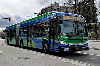
The R1 King George Blvd is an express bus service with bus rapid transit elements in Metro Vancouver, British Columbia, Canada. Part of TransLink's RapidBus network, it travels along King George Boulevard and 104 Avenue in Surrey and connects Guildford, Whalley / City Centre, and Newton. The service replaced the 96 B-Line on January 6, 2020. It is operated by Coast Mountain Bus Company and funded by TransLink.
Forest Knolls is a neighbourhood in the Township of Langley in the Fraser Valley of British Columbia, Canada. It is located immediately south of Fort Langley. It is an affluent community of homes situated on small acreages.