
Surrey is a city in British Columbia, Canada. It is located south of the Fraser River on the Canada–United States border. It is a member municipality of the Metro Vancouver regional district and metropolitan area. Mainly a suburban city, Surrey is the province's second-largest by population after Vancouver and the third-largest by area after Abbotsford and Prince George. Seven neighbourhoods in Surrey are designated town centres: Cloverdale, Fleetwood, Guildford, Newton, South Surrey, and City Centre encompassed by Whalley.

The Township of Langley is a district municipality immediately east of the City of Surrey in southwestern British Columbia, Canada. It extends south from the Fraser River to the Canada–United States border, and west of the City of Abbotsford. Langley Township is not to be confused with the City of Langley, which is adjacent to the township but politically is a separate entity. Langley is located in the eastern part of Metro Vancouver.

The Expo Line is the oldest line of the SkyTrain rapid transit system in the Metro Vancouver region of British Columbia, Canada. The line is owned and operated by BC Rapid Transit Company, a subsidiary of TransLink, and links the cities of Vancouver, Burnaby, New Westminster and Surrey.
Highway 17 is a provincial highway in British Columbia, Canada. It comprises two separate sections connected by a ferry link. The Vancouver Island section is known as the Patricia Bay Highway and connects Victoria to the Swartz Bay ferry terminal in North Saanich. The Lower Mainland section is known as the South Fraser Perimeter Road and connects the Tsawwassen ferry terminal to Delta and Surrey, terminating at an interchange with Highway 1 in the Fraser Valley.
Highway 99 is a provincial highway in British Columbia that runs 377 kilometres (234 mi) from the U.S. border to near Cache Creek, serving Greater Vancouver and the Squamish–Lillooet corridor. It is a major north–south artery within Vancouver and connects the city to several suburbs as well as the U.S. border, where it continues south as Interstate 5. The central section of the route, also known as the Sea to Sky Highway, serves the communities of Squamish, Whistler, and Pemberton. Highway 99 continues through Lillooet and ends at a junction with Highway 97 near Cache Creek.
Highway 99A is a series of former highways in the southwestern part of British Columbia, Canada. It was the designation of the former 1942 alignment of Highway 99 as well a various alternate routes which existed in the 1950s and 1960s. The last official use of '99A' was decommissioned in 2006, although some present-day, commercially published road maps still show it and some remnant signage still remains. Some brand new 99A signs can be seen as well as of 2023.
Highway 15 (BC 15), known locally as the Pacific Highway, is a 20.99-kilometre-long (13.04 mi) north–south highway primarily located in the City of Surrey, British Columbia. The southern terminus is with Interstate 5 (I-5) near Blaine, Washington, as State Route 543 (SR 543). SR 543 is a 1.75-kilometre-long (1.09 mi) connector between I-5 and the Canada–US border, linking with BC 15. Over 3,000 trucks per day pass through the border crossing along SR 543 and BC 15, because the Peace Arch border crossing does not allow commercial trucks.
There are many roads in the southwestern part of British Columbia and Vancouver Island that were designated as Highway 1A. These roads were sections of the original 1941 route of Highway 1 before its various re-alignments, and are used today as service routes and frontage roads. The "B.C. Highway 1A" designations were removed from these sections by the province between 2005 and 2010, although signage remains along some of the route and the designation on some maps.

Scott Road is an elevated station on the Expo Line of Metro Vancouver's SkyTrain rapid transit system. The station is located near the south end of the Pattullo Bridge in the South Westminster neighbourhood of Surrey, British Columbia, Canada. It also serves the Bridgeview neighbourhood of Whalley, and the interchange between King George Boulevard and Scott Road is located to the north of the station. The station opened on March 16, 1990, and was renovated from 2013 to 2014.

Kingsway is a major thoroughfare that crosses through the Canadian cities of Vancouver and Burnaby, British Columbia. The road runs diagonally from northwest to southeast, emerging from Vancouver's Main Street just south of East 7th Avenue and becoming 12th Street at the Burnaby–New Westminster border.
Whalley is the most densely populated and urban of the six town centres in Surrey, British Columbia, Canada. It encompasses City Centre, the city's central business district, and is home to the Surrey City Hall, the main branch of Surrey Libraries, Central City, SFU Surrey and the site of Kwantlen Polytechnic University's (KPU) Civic Plaza campus. It is the only town centre in Surrey served by Metro Vancouver's SkyTrain rapid transit system. Expo Line stations serving Whalley include Scott Road, Gateway, Surrey Central and King George.

Fraser Highway is a 38-kilometre-long (24 mi) major arterial road in the Lower Mainland of British Columbia. Connecting the cities of Surrey and Abbotsford, the highway formerly constituted a major portion of British Columbia Highway 1A until the latter was decommissioned in 2006. The highway is named for the Fraser River and the Fraser Valley, which are in turn named for the explorer Simon Fraser.
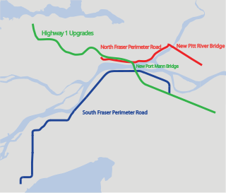
The Gateway Program is a C$3.0 billion regional transportation project for Metro Vancouver and surrounding areas that is being managed by the British Columbia Ministry of Transportation. The ministry introduced the Gateway Program on January 31, 2006, as a means to address growing congestion and reduce travel times. The bulk of the construction took place from 2006 to 2014 and saw the completion of the Golden Ears Bridge, the Pitt River Bridge, the Port Mann Bridge, improvements on the Sea-to-Sky highway, and finally the construction of the South Fraser Perimeter Road. The Greater Gateway Program is expected to finish by 2030.
Sunnyside is a neighbourhood of South Surrey, which in turn is a region of Surrey, British Columbia, Canada.
The 400-series highways were a pair of controlled-access highways located in the southwestern portion of the Canadian province of British Columbia, forming a special subset of the provincial highway system. Modelled after the 400-Series Highways in Ontario, 400-series designations were introduced in 1964 in conjunction with the completion of the Trans-Canada Highway freeway between Vancouver and Clearbrook ; however, unlike their Ontario counterparts, both routes had signalized sections. The 400-series system never expanded beyond two freeways, and in 1973 Highways 401 and 499 were renumbered 1 and 99 respectively, while the former routes were assigned the 'A' suffix.
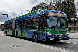
The R1 King George Blvd is an express bus service with bus rapid transit elements in Metro Vancouver, British Columbia, Canada. Part of TransLink's RapidBus network, it travels along King George Boulevard and 104 Avenue in Surrey and connects Guildford, Whalley / City Centre, and Newton. The service replaced the 96 B-Line on January 6, 2020. It is operated by Coast Mountain Bus Company and funded by TransLink.

South Westminster is an industrial neighbourhood in the Whalley town centre of Surrey, British Columbia, Canada, located on the Fraser River south of the city of New Westminster.

Bridgeview is a neighbourhood in the Whalley town centre of Surrey, British Columbia, Canada, that stretches south from the Fraser River to King George Boulevard. The neighbourhood consists of all the low-lying area between the Port Mann Bridge in the east and the Pattullo Bridge in the west.
Marine Drive is the name for three major roadways in Greater Vancouver, British Columbia, Canada. The roads are known for running parallel to major bodies of water, with some sections being a major arterial road, while other serve local traffic. Marine Way is the name applied to a section of Marine Drive that was bypassed in the early 1980s.

