The London Borough of Southwark in south London forms part of Inner London and is connected by bridges across the River Thames to the City of London. It was created in 1965 when three smaller council areas amalgamated under the London Government Act 1963. All districts of the area are within the London postal district. It is governed by Southwark London Borough Council.

Bridgeview is a village in Cook County, Illinois, United States. It is located approximately 15 miles (24 km) southwest of the Chicago Loop. As of the 2010 census, the village population was 16,446.

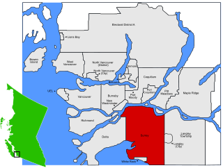
Surrey is a city in the province of British Columbia, Canada, located south of the Fraser River and north of the Canada–United States border. It is a member municipality of the Metro Vancouver regional district and metropolitan area. Mainly a suburban city, Surrey is the province's second-largest by population after Vancouver and the third-largest by area after Abbotsford and Prince George. Seven neighbourhoods in Surrey are designated "town centres": Fleetwood, Whalley, City Centre, Guildford, Newton, Cloverdale, and South Surrey.

The Regional Municipality of York, also called York Region, is a regional municipality in Southern Ontario, Canada, between Lake Simcoe and Toronto. It replaced the former York County in 1971, and is part of the Greater Toronto Area and the inner ring of the Golden Horseshoe. The regional government is headquartered in Newmarket.

Lambeth is a district in South London, England, in the London Borough of Lambeth, historically in the County of Surrey. It is situated 1 mile (1.6 km) south of Charing Cross. The population of the London Borough of Lambeth was 303,086 in 2011. The area experienced some slight growth in the medieval period as part of the manor of Lambeth Palace. By the Victorian era the area had seen significant development as London expanded, with dense industrial, commercial and residential buildings located adjacent to one another. The changes brought by World War II altered much of the fabric of Lambeth. Subsequent development in the late 20th and early 21st centuries has seen an increase in the number of high-rise buildings. The area is home to the International Maritime Organization.
Highway 99A was the designation of Highway 99's original 1942 alignment. It has had the '99A' designation between 1962 and 1964, and from 1973 to 2006 when it was decommissioned, although as of 2017 commercially published road maps still show it.

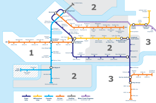
King George is an elevated station on the Expo Line of Metro Vancouver's SkyTrain rapid transit system. The station is located in the south end of the Surrey City Centre district of Surrey, British Columbia, Canada, and is one of the outbound termini of the Expo Line, the other being Production Way–University station. The station is located at the corner of King George Boulevard and 100 Avenue, just north of Fraser Highway.

Scott Road is an elevated station on the Expo Line of Metro Vancouver's SkyTrain rapid transit system. The station is located near the south end of the Pattullo Bridge in the South Westminster neighbourhood of Surrey, British Columbia, Canada. The station also serves the Bridgeview neighbourhood of Whalley, and the interchange between King George Boulevard and Scott Road is located to the north of the station.
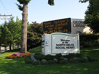
North Delta is a largely middle-class commuter town situated in the Lower Mainland, of British Columbia, Canada. The community is the most populous of the three communities that make up the City of Delta. North Delta is home to numerous parks and recreational opportunities. Alongside North Delta is Burns Bog, the largest raised peat urban bog in North America. As well, Watershed Park provides walking and biking trails, home to many artesian aquifers. Besides this, North Delta is home to a large amount of green-space. As of the 2016 census, North Delta has a population of 56,017.

The A217 is a road in London and Surrey in England. It runs north/south. It runs from Kings Road in Fulham, London, crosses the Thames at Wandsworth Bridge, then passes through Wandsworth, Earlsfield, Summerstown, Tooting, Mitcham, Rosehill and Sutton Common in Sutton, then Cheam. Then, widened as a dual carriageway, comes Belmont, a suburban district built on a slope rising southward. On the North Downs in Surrey the road then skirts past Banstead and through its late 19th century offspring villages particularly Burgh Heath and Kingswood, Surrey. It then crosses the M25 motorway at Junction 8, then, returning to single carriageways, passes through the castle town of Reigate. It then cuts through the green buffer farmland of two rural villages and terminates at the road network at Gatwick Airport's northern perimeter.

Black Creek is a river in the Golden Horseshoe region of Ontario, Canada. It flows from the city of Vaughan in the Regional Municipality of York to the Humber River in Toronto. Black Creek is smaller than most of the waterways in the Greater Toronto Area.
Transportation in Vancouver, British Columbia has many of the features of modern cities worldwide. Unlike many large metropolises, Vancouver has no freeways into or through the downtown area. A proposed freeway through the downtown was rejected in the 1960s by a coalition of citizens, community leaders and planners. This event "signalled the emergence of a new concept of the urban landscape" and has been a consistent element of the city's planning ever since.

South Surrey is a community within the City of Surrey, British Columbia, located on the Semiahmoo peninsula in the southern portion of the city of Surrey, sharing a border with the city of White Rock. Neighbourhoods of South Surrey include Crescent Beach, Crescent Heights, Elgin, Chantrell Creek, Grandview Heights, Hazelmere, Ocean Park, and Sunnyside.
The 1928 Thames flood was a disastrous flood of the River Thames that affected much of riverside London on 7 January 1928, as well as places further downriver. Fourteen people died and thousands were made homeless when floodwaters poured over the top of the Thames Embankment and part of the Chelsea Embankment collapsed. It was the last major flood to affect central London, and, along with the disastrous North Sea flood of 1953, helped lead to the implementation of new flood-control measures that culminated in the construction of the Thames Barrier in the 1970s.
Windsor, Ontario has a very diverse population, and this diversity is shown in its many neighbourhoods. Windsor has twenty in all, ranging from rural farmland to densely built-up areas.
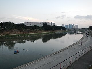
Marikina River is a river in eastern Metro Manila, Philippines. It is a tributary of Pasig River with headwaters located in the Sierra Madre Mountains in Rodriguez, Rizal province.

Crescent Beach is a beachside community within the South Surrey town centre of Surrey, British Columbia, Canada next to Boundary Bay and Mud Bay across from the municipality of Delta. It is home to 1,200 residents, mostly in single-family homes.
Sunnyside is a neighbourhood of South Surrey, which in turn is a region of Surrey, British Columbia, Canada.

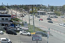
King George Boulevard is a major arterial road in Surrey, British Columbia, Canada. The 26 km (16 mi) route begins at Highway 99, 1.6 km (1.0 mi) north of the Peace Arch Border Crossing with the United States; and runs generally northwest to the south end of the Pattullo Bridge, a crossing of the Fraser River that connects Surrey with New Westminster. The majority of the route varies from four to six lanes, and some sections in the north run parallel to the Expo Line, which has two adjacent SkyTrain stations: Scott Road station in South Westminster, and King George station in the Surrey City Centre district.

South Westminster is an industrial neighbourhood in the Whalley town centre of Surrey, British Columbia, Canada, located on the Fraser River south of the city of New Westminster.