Crescent Beach, Surrey

Last updated
Crescent Beach
Neighbourhood of Surrey
Cresbeach-groyne.jpg
A groyne at Crescent Beach
15 Metro Vancouver Regional District British Columbia.svg
Red pog.svg
Crescent Beach
Location within Metro Vancouver
Coordinates: 49°03′08″N122°53′02″W / 49.05222°N 122.88389°W / 49.05222; -122.88389
Country Canada
Province British Columbia
Region Lower Mainland
Regional district Metro Vancouver
City Surrey
Government
   Mayor Brenda Locke
   MP (Fed.) Kerry-Lynne Findlay (Conservative)
   MLA (Prov.) Elenore Sturko (United)
Population
 (2014)
  Total1,200 [1]
Time zone UTC−8 (PST)
  Summer (DST) UTC−7 (PDT)

Crescent Beach is a beachside community within the South Surrey town centre of Surrey, British Columbia, Canada next to Boundary Bay and Mud Bay, across from Delta, British Columbia. It is home to 1,200 residents, mostly in single-family homes. [1]

Contents

History

Crescent Beach has been a summer destination for centuries. In pre-colonial times, it was the location of a significant temporary summer camp for area aboriginals. The tidal mudflats were a good clam digging area. Wild berries, especially cranberries, and a weir site were located at nearby Nicomekl River and Serpentine River areas. The area was part of Snokomish territory until a smallpox epidemic in 1850 forced the survivors and their lands to be amalgamated into the Semiahmoo First Nation. [2] Musqueam bands also travelled to use the lands seasonally. [3]

Artifacts such as arrowheads and jade have been found on the beach in the modern era. [4] First Nations' burial sites were uncovered in 1970 by sewer excavation. [3]

The Semiahmoo First Nation attributes three to five metres depth of the land base to archaeological deposits of clams, charcoal and fire-cracked rocks without which the area would largely just be a sandspit. Modern excavations in some parts have also uncovered more than 700 human remains. [5]

The first Europeans to chart the area were Spanish sailors. Captain Galiano titled it San Rafael Point on his map. [3]

After the creation of British Columbia, the first owner of Crescent Beach area was John Musselwaite of Royal Engineers in 1871. [3]

In 1909, the development of the Great Northern Railway from Blaine, Washington to New Westminster provided easier access to the beach for Vancouver-area residents. In 1913, permanent dikes (now serving as the waterfront walkway) were established to permit subdivision development. 1912 saw a development of pier and the Crescent Beach Development Company promoted Crescent Beach as a resort area. Notable Vancouverites began building summer homes in the neighbourhood. That year, Captain Watkin Williams also opened the Crescent Beach Hotel, a 21-room building with a restaurant, store and post office. The hotel burned down in February 1950. [4]

Oyster imported from Japan seeded a thriving business for some decades until the Crescent Oyster Company was closed in 1961 due to river pollution and contemporary concerns about shellfish paralytic poisoning. [4]

Recreation

South-facing view of Crescent Beach at high tide Southview Crescent Beach Surrey 1.jpg
South-facing view of Crescent Beach at high tide

Crescent Beach is home to Alexandra Neighbourhood House, the Wickson Pier and Blackie Spit Park, all local landmarks. Crescent Beach is the home of the "Crescent Beach Swim Club", a local club that offers swimming, sailing, tennis, water polo, volleyball, and triathlon lessons to children.

South-facing view of beach and walkway in Crescent Beach in Surrey, British Columbia Crescent Beach walkway.jpg
South-facing view of beach and walkway in Crescent Beach in Surrey, British Columbia

On the southern end of Crescent Beach near the bottom of 101 steps staircase at 24 Avenue is the 120 tonne Crescent Rock boulder. Crescent Rock Beach is the 6.5 km. long rugged strip of shoreline from this large rock to White Rock at the base of the Ocean Park bluffs that is utilized by naturists and nudists for nude sunbathing and skinny-dipping. The City of Surrey refuses to endorse its clothing-optional use as it is outside their jurisdiction but the RCMP have acknowledged that nude use on this area out of sight from the marine parks at Crescent Beach and White Rock is legal under Canadian case law. [6]

The beach area has showers to wash feet and legs to prevent swimmer's itch, a short-term immune reaction caused by waterborne parasites seeking freshwater snails. [4]

Blackie Spit birdwatching

Northeast-facing view of Mud Bay from Blackie Spit Mud Bay from Blackie Spit.jpg
Northeast-facing view of Mud Bay from Blackie Spit

The northernmost portion of Crescent Beach is Blackie Spit, named after a settler and known as a birdwatching site beside Mud Bay and near Nicomekl River. [7] The City of Surrey created Blackie Spit Park in 1996.

North-facing view of Mud Bay at high tide from Blackie Spit. Skyscrapers in Burnaby and the North Shore Mountains visible in distant background Northview from Mid Bay 2014.jpg
North-facing view of Mud Bay at high tide from Blackie Spit. Skyscrapers in Burnaby and the North Shore Mountains visible in distant background

The park is an annual migration rest stop for the Pacific Flyway for 300 species of birds including 10,000 ducks and geese. It is the only area in Boundary Bay where purple martins nest. The eelgrass meadows, mud flats and tidal marsh serve as bird habitats year-round. Shorebirds feed off biofilms, a paper-thin mucus, that consist of bacteria, diatoms (microscopic plants) and organic detritus. [8]

Transportation

Crescent Beach has two accesses by road to the rest of Surrey (Crescent Road and McBride Avenue) which both cross the BNSF Railway. Implications for emergency access and the impact of noise and coal dust from the trains are long-time concerns for residents. [9] From 2002 to 2014, the number of trains quadrupled from five to 20 a day. [1]

Public transportation is provided by TransLink bus route 350. The commuter bus service connects Crescent Beach to White Rock Centre.

The 4.5 kilometres (2.8 mi) Crescent Road corridor connects the beach area to King George Boulevard near Nicomekl River. The road is registered with the city and national historic place registries because it enabled transport to pioneer locations (such as Historic Stewart Farm) due to its first construction in 1882 shortly after incorporation of the City of Surrey. [10]

Beecher Street, known as the Marine Drive of Crescent Beach, is home to bistros, ice cream cafes and small stores. [7]

Boats are also stored at Crescent Beach Marina at the tip of Nicomekl River.

Arts & culture

A 2008 teen novel Reading the Bones by Gina McMurchy-Barber featured 12-year-old heroine Peggy Henderson uncovering an archaeological skull in her uncle's backyard in Crescent Beach. [11]

Scenes from the 2010 film Tron: Legacy were filmed along the waterfront at Crescent Beach, with one of the houses there functioning as the home of Kevin and Sam Flynn. [12]

In 2012, Beach House Theatre began annual production of Shakespeare plays in August in open-ended tents similar to Vancouver's Bard on the Beach festival. [13] In 2015, Beach House Theatre began performing plays outside of Shakespeare, starting with Oscar Wilde's The Importance of Being Earnest. [14]

A season two episode of Better Things was filmed at Crescent Beach in June 2017 near the main swimming area. [15]

See also

Related Research Articles

<span class="mw-page-title-main">Surrey, British Columbia</span> City in British Columbia, Canada

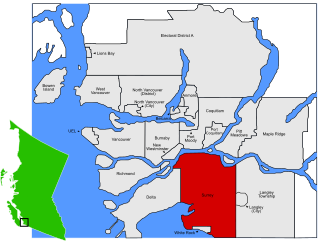
Surrey is a city in British Columbia, Canada. It is located south of the Fraser River on the Canada–United States border. It is a member municipality of the Metro Vancouver regional district and metropolitan area. Mainly a suburban city, Surrey is the province's second-largest by population after Vancouver and the third-largest by area after Abbotsford and Prince George. Seven neighbourhoods in Surrey are designated town centres: Cloverdale, Fleetwood, Guildford, Newton, South Surrey, and City Centre encompassed by Whalley.

<span class="mw-page-title-main">White Rock, British Columbia</span> City in British Columbia, Canada

White Rock is a city in British Columbia, Canada, and a member municipality of the Metro Vancouver Regional District. It borders Semiahmoo Bay to the south and is surrounded on three sides by Surrey. To the southeast across a footbridge lies the Semiahmoo First Nation, which is within the borders of Surrey. Semiahmoo Bay and the Southern Gulf Islands in the Strait of Georgia are also to the south.

<span class="mw-page-title-main">Langley, British Columbia (city)</span> City in British Columbia, Canada

The City of Langley, commonly referred to as Langley City, or just Langley, is a municipality in the Metro Vancouver Regional District in British Columbia, Canada. It lies directly east of Surrey, adjacent to the Cloverdale area, and is surrounded elsewhere by the Township of Langley, bordered by its neighbourhoods of Willowbrook to the north, Murrayville to the east, and Brookswood and Fern Ridge to the south.

<span class="mw-page-title-main">Boundary Bay</span> Bay on the Canada–United States border

Boundary Bay is a shallow bay situated on the Pacific coast of North America on the Canada–United States border between the Canadian province of British Columbia and the U.S. state of Washington.

<span class="mw-page-title-main">Peace Arch Border Crossing</span> Border crossing between Canada and the United States

The Peace Arch Border Crossing is the common name for the Blaine–Douglas crossing which connects the cities of Blaine, Washington and Surrey, British Columbia on the Canada–United States border. I-5 on the American side joins BC Highway 99 on the Canadian side. Being the most direct route between the major cities of Seattle, Washington and Vancouver, British Columbia, the crossing is the third-busiest on the border with up to 4,800 cars a day. Trucks and other commercial vehicles are prohibited from this location and use the Pacific Highway Border Crossing, which is 1.6 kilometres (1 mi) eastward.

<span class="mw-page-title-main">Semiahmoo Shopping Centre</span> Shopping mall in British Columbia, Canada

Semiahmoo Shopping Centre is an indoor shopping mall on the Semiahmoo peninsula in Surrey, British Columbia, Canada. Opened in 1980, the shopping centre is named after the nearby Semiahmoo Bay and is currently anchored by Save-On-Foods and Winners.

<span class="mw-page-title-main">South Surrey</span> Town centre of Surrey in British Columbia, Canada

South Surrey is a community within the City of Surrey, British Columbia, located on the Semiahmoo peninsula in the southern portion of the City of Surrey, sharing a border with the City of White Rock. Neighbourhoods of South Surrey include Crescent Beach, Crescent Heights, Elgin, Chantrell Creek, Morgan Creek, Grandview Heights, Hazelmere, Ocean Park, and Sunnyside. Most of South Surrey lies in White Rock's population centre.

<span class="mw-page-title-main">Nicomekl River</span> River in Canada

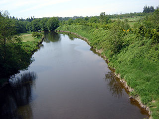
The Nicomekl River springs from the ground in Langley, British Columbia and travels west through the city to Surrey's Crescent Beach, where it empties into Mud Bay, the northernmost section of the Boundary Bay of the Strait of Georgia. It has a total length of 34 km, with a drainage area of 149 km2.

<span class="mw-page-title-main">Ocean Park, Surrey</span> Neighborhood in British Columbia, Canada

Ocean Park is a neighbourhood of South Surrey, a region of Surrey, British Columbia.

<span class="mw-page-title-main">Semiahmoo Bay</span>

Semiahmoo Bay is the southeastern section of Boundary Bay on the Pacific coast of North America. The bay is named for the Semiahmoo First Nation, who originally occupied the area. The Semiahmoo Peninsula borders the bay and was home to cannery operations. It is now home to the Semiahmoo Golf Resort.

<span class="mw-page-title-main">Semiahmoo First Nation</span>

<span class="mw-page-title-main">Semiahmoo Spit</span>

Semiahmoo Spit is a spit that protrudes from the westernmost expanse of shore on Semiahmoo Peninsula between Semiahmoo Bay and Drayton Harbor off the coast of Blaine in Whatcom County, Washington state. The spit is home to Semiahmoo Park

<span class="mw-page-title-main">Campbell River (Semiahmoo Bay)</span> River in British Columbia, Canada

The Campbell River passes through Surrey and Langley, British Columbia, Canada, entering Semiahmoo Bay at the Semiahmoo Indian Reserve, which lies between the City of White Rock and Peace Arch Park on the international boundary.

The Semiahmoo are a Coast Salish indigenous people whose homeland is in the Lower Mainland region of southwestern British Columbia, Canada.

<span class="mw-page-title-main">Sunnyside, Surrey</span> Neighbourhood in Lower Mainland, British Columbia, Canada

Sunnyside is a neighbourhood of South Surrey, which in turn is a region of Surrey, British Columbia, Canada.

The Kennedy Trail was the first settler built trail in the Lower Mainland of British Columbia, Canada. James Kennedy first proposed "a trail from some point opposite New Westminster, across to some other point near to Semiahmoo Bay" in a letter written to Governor James Douglas in June 1860. He said "it would be the cause of speedy settlement of the land". In January 1861 Kennedy signed a contract to build the trail with the Chief Commissioner of Lands and Works, Colonel Richard Clement Moody.

The Snokomish were a Halkomelem-speaking Coast Salish people whose territory was primarily located across the Boundary Bay area. The Snokomish were also known as the Derby people, as their territory included a portion of the Fraser River, near Derby, British Columbia.

Marine Drive is the name for three major roadways in Greater Vancouver, British Columbia, Canada. The roads are known for running parallel to major bodies of water, with some sections being a major arterial road, while other serve local traffic. Marine Way is the name applied to a section of Marine Drive that was bypassed in the early 1980s.

References

  1. 1 2 3 Reid, Amy (July 15, 2014). "Neighbourhoods: Crescent Beach is Surrey's 'hang ten' seaside village". The Now. Surrey, British Columbia. Archived from the original on August 4, 2014.
  2. Brown, Jack (2012). "Semiahmoo Encampments". surreyhistory.ca. Retrieved 3 August 2014.
  3. 1 2 3 4 "Crescent Beach". City of Surrey. Archived from the original on 12 July 2016. Retrieved 27 July 2016.
  4. 1 2 3 4 "Neighbourhoods: The history of Crescent Beach". The Now. Surrey, British Columbia. July 24, 2014. Archived from the original on August 2, 2014.
  5. Don Welsh (August 5, 2014). "Letters: Beach history more extensive". Peace Arch News. White Rock, British Columbia.
  6. "Surrey's United Naturists". crescentrockbeach.org. Archived from the original on 25 August 2014. Retrieved 3 August 2014.
  7. 1 2 Staff Writer (August 15, 2011). "Semiahmoo: Life's a beach". Surrey Leader. Retrieved 3 August 2014.
  8. Jack Christie (December 15, 2002). "A Day at Mud Bay". British Columbia Magazine.
  9. "Railing against coal trains". bclocalnews.com. March 20, 2013. Retrieved 3 August 2014.
  10. "Crescent Road". Canada's Historic Places. Retrieved 27 July 2016.
  11. Reading the Bones: A Peggy Henderson Adventure
  12. Peter T. Chattaway (June 18, 2012). "Farewell to Crescent Beach". patheos.com blog. Retrieved Sep 26, 2013.
  13. Browne, Alex (Nov 9, 2011). "Perchance to dream in Crescent Beach". Peace Arch News. Retrieved 3 August 2014.
  14. Browne, Alex (18 Feb 2015). "Beach House Goes Wilde for 2015 Season". Peace Arch News. Retrieved 19 March 2017.
  15. whatsfilming (2017-06-01). "Better Things Season 2 Filming 1 Episode in Vancouver". What's Filming?. Retrieved 2017-06-02.

Surrounding neighbourhoods