
Surrey is a city in British Columbia, Canada. It is located south of the Fraser River on the Canada–United States border. It is a member municipality of the Metro Vancouver regional district and metropolitan area. Mainly a suburban city, Surrey is the province's second-largest by population after Vancouver and the third-largest by area after Abbotsford and Prince George. Seven neighbourhoods in Surrey are designated town centres: Cloverdale, Fleetwood, Guildford, Newton, South Surrey, and City Centre encompassed by Whalley.

The Township of Langley is a district municipality immediately east of the City of Surrey in southwestern British Columbia, Canada. It extends south from the Fraser River to the Canada–United States border, and west of the City of Abbotsford. Langley Township is not to be confused with the City of Langley, which is adjacent to the township but politically is a separate entity. Langley is located in the eastern part of Metro Vancouver.
Pitt Meadows is a municipality within Metro Vancouver in southwestern British Columbia, Canada. Incorporated in 1914, it currently has a land area of 86.34 square kilometres (33.34 sq mi) with a population of 19,146 as of 2021. The municipality received its name from the Pitt River and Pitt Lake. Pitt Meadows is one of 21 municipalities including Electoral Area A that comprises the Metro Vancouver Regional District.

The City of Langley, commonly referred to as Langley City, or just Langley, is a municipality in the Metro Vancouver Regional District in British Columbia, Canada. It lies directly east of Surrey, adjacent to the Cloverdale area, and is surrounded elsewhere by the Township of Langley, bordered by its neighbourhoods of Willowbrook to the north, Murrayville to the east, and Brookswood and Fern Ridge to the south.
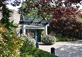
Whalley is the most densely populated and urban of the six town centres in Surrey, British Columbia, Canada. It encompasses City Centre, the city's central business district, and is home to the Surrey City Hall, the main branch of Surrey Libraries, Central City, SFU Surrey and the site of Kwantlen Polytechnic University's (KPU) Civic Plaza campus. It is the only town centre in Surrey served by Metro Vancouver's SkyTrain rapid transit system. Expo Line stations serving Whalley include Scott Road, Gateway, Surrey Central and King George.

Guildford is a town centre and neighbourhood of Surrey, British Columbia, Canada. It is known for its retail corridors along 104 Avenue and 152 Street. At the intersection of these two streets sits the 200-store Guildford Town Centre. The community is named after Guildford in Surrey, England.

South Surrey is a community within the City of Surrey, British Columbia, located on the Semiahmoo peninsula in the southern portion of the City of Surrey, sharing a border with the City of White Rock. Neighbourhoods of South Surrey include Crescent Beach, Crescent Heights, Elgin, Chantrell Creek, Morgan Creek, Grandview Heights, Hazelmere, Ocean Park, and Sunnyside. Most of South Surrey lies in White Rock's population centre.

Dunbar–Southlands is a neighbourhood situated on the western side of Vancouver, British Columbia, Canada, that stretches north from the Fraser River and covers most of the land between the mouth of the Fraser and English Bay.

Killarney is a neighbourhood in East Vancouver, British Columbia with a population of over 28,000 in 2011 and lies in the far southeast corner of the city. It is on the south slope of the ridge that rises above the Fraser River, and contains a collection of single-family residences with a few multi-family homes as well as the townhouses and high-rises of the Fraserlands development along the river.

Fraser Heights Secondary is a public high school in the Fraser Heights neighbourhood situated in Surrey, British Columbia and is part of School District 36 Surrey.
McMillan Island is an island in the Fraser River, British Columbia, Canada, also known as McMillan Slough..
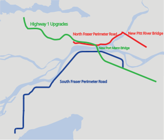
The Gateway Program is a C$3.0 billion regional transportation project for Metro Vancouver and surrounding areas that is being managed by the British Columbia Ministry of Transportation. The ministry introduced the Gateway Program on January 31, 2006, as a means to address growing congestion and reduce travel times. The bulk of the construction took place from 2006 to 2014 and saw the completion of the Pitt River Bridge, the Port Mann Bridge, improvements to Highway 1 and construction of the South Fraser Perimeter Road.
Laurier Heights is a residential neighbourhood in west Edmonton, Alberta, Canada overlooking the North Saskatchewan River valley. A portion of the neighbourhood along Buena Vista Road is located in the river valley, and this portion is sometimes called Buena Vista.

Ottewell is a large residential neighbourhood in east Edmonton, Alberta, Canada. "The area is named for the Ottewell family, who were among the first settlers south of the river in the 1880s".
Sunnyside is a neighbourhood of South Surrey, which in turn is a region of Surrey, British Columbia, Canada.
Patricia Heights is a neighbourhood in west Edmonton, Alberta, Canada. It is bounded by the Patricia Ravine of the North Saskatchewan River valley and ravine system to the south and southwest, the Westridge neighbourhood to the west, the Elmwood and Lynnwood neighbourhoods across Whitemud Drive to the north, and the Rio Terrace neighbourhood across 156 Street to the east.
Clareview is a residential area in the northeast portion of the city of Edmonton in Alberta, Canada. It was established in 1972 through Edmonton City Council's adoption of the Clareview Outline Plan, which guides the overall development of the area. Clareview station is the northern terminus of the Edmonton LRT.

King George Boulevard is a major arterial road in Surrey, British Columbia, Canada. The 26-kilometre (16 mi) route begins at Highway 99, 1.6 kilometres (1.0 mi) north of the Peace Arch Border Crossing with the United States, and runs generally northwest to the south end of the Pattullo Bridge, a crossing of the Fraser River that connects Surrey with New Westminster. The majority of the route varies from four to six lanes, and some sections in the north run parallel to the Expo Line, which has two adjacent SkyTrain stations: Scott Road station in South Westminster, and King George station in the Surrey City Centre district.
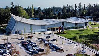
The Grandview Heights Aquatic Centre (GHAC) is an indoor Olympic-sized aquatic centre in Surrey, British Columbia, Canada. It is located in the Grandview Heights neighbourhood of South Surrey, and was designed by HCMA Architecture + Design, built at a cost of $55 million and opened in June 2016. The facility features a 10-lane 50-meter lap pool, leisure pool with lazy river, hot tubs, diving towers and a water slide in addition to a sauna and steam room.
