
Maple Ridge is a city in British Columbia, Canada. It is located in the northeastern section of Greater Vancouver between the Fraser River and the Golden Ears, which is a group of mountain summits which are the southernmost of the Garibaldi Ranges of the Coast Mountains. Maple Ridge's population in 2021 was 90,990. Its downtown core is known as Haney.

Port Coquitlam is a city in British Columbia, Canada. It is one of 21 municipalities comprising Metro Vancouver. Located 27 km (17 mi) east of Vancouver, it is on the north bank of the confluence of the Fraser River and the Pitt River. Coquitlam borders it to the north and west. Pitt Meadows lies across the Pitt River from it. Port Coquitlam is bisected by Lougheed Highway and the Canadian Pacific Kansas City. Port Coquitlam is often referred to as "PoCo". It is Canada's 93rd-largest municipality by population.

Mission is a city in the Lower Mainland of the province of British Columbia, Canada. It was originally incorporated as a district municipality in 1892, growing to include additional villages and rural areas over the years, adding the original Town of Mission City, long an independent core of the region, in 1969. It is bordered by the city of Abbotsford to the south and the city of Maple Ridge to the west. To the east are the unincorporated areas of Hatzic and Dewdney.
Pitt Meadows is a municipality of Metro Vancouver in southwestern British Columbia, Canada. Incorporated in 1914, it has a land area of 86.34 square kilometres (33.34 sq mi) and a population of 19,146 as of 2021. The municipality received its name from the Pitt River and Pitt Lake. Pitt Meadows is one of 21 municipalities plus Electoral Area A that comprises the Metro Vancouver Regional District.

The West Coast Express is a commuter railway serving the Lower Mainland region of British Columbia, Canada. It is owned and operated by the region's transit authority, TransLink. Opened in 1995, it provides a link between Metro Vancouver and the Fraser Valley Regional District and is the only commuter railway in Western Canada. In 2022, the system had a ridership of 885,000, or about 4,800 per weekday as of the first quarter of 2023.

Pitt Meadows—Maple Ridge—Mission was a federal electoral district in British Columbia, Canada, that was represented in the House of Commons of Canada from 1997 to 2015.
Highway 7, known for most of its length as the Lougheed Highway and Broadway, is an alternative route to Highway 1 through the Lower Mainland region of British Columbia. Whereas the controlled-access Highway 1 follows the southern bank of the Fraser River, Highway 7 follows the northern bank.
Highway 7A, known locally and on street signs as the Barnet Highway, Barnet Road,St. Johns Street, Inlet Drive and Hastings Street, was Highway 7's original 1941 route between the harbour in Vancouver and Port Moody. The highway gained the 7A designation around 1953 due to Highway 7 being re-designated along Lougheed Highway through Maillardville and Central Burnaby and was disestablished on April 1, 1999.

Highway 7B, known as the Mary Hill Bypass, is a 7.27 km (4.52 mi) long riverside east-west link between the cities of Coquitlam to the west and Port Coquitlam to the east. The Mary Hill Bypass gained its numbered designation in 1996, when it was widened from two to four lanes north of Broadway. Highway 7B meets Highway 7 at both of its ends, and also links to Highway 1 within Coquitlam at the Cape Horn Interchange.
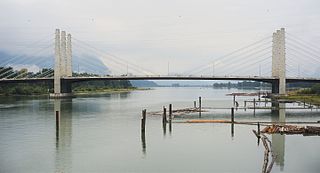
The Pitt River Bridge is a cable-stayed bridge that spans the Pitt River between Port Coquitlam and Pitt Meadows in British Columbia, Canada. The bridge is part of Highway 7, carrying Lougheed Highway across the river. The current bridge opened on October 4, 2009. The bridge includes a 380 m cable stay bridge structure, 126 m of multi-span approaches, a 50 m interchange structure and approximately 2 km of grade construction. Total project cost for the bridge was $200 million

The Pitt River in British Columbia, Canada is a large tributary of the Fraser River, entering it a few miles upstream from New Westminster and about 25 km ESE of Downtown Vancouver. The river, which begins in the Garibaldi Ranges of the Coast Mountains, is in two sections above and below Pitt Lake and flows on a generally southernly course. Pitt Lake and the lower Pitt River are tidal in nature as the Fraser's mouth is only a few miles downstream from their confluence.

The 97 B-Line was an express bus line in Metro Vancouver, British Columbia, Canada. It connected Coquitlam Central station on the West Coast Express system to Lougheed Town Centre station on the SkyTrain system. It was operated by Coast Mountain Bus Company and funded by TransLink. Going west, the route went along Clarke Rd., St. John's St., Ioco Rd, Guildford Way and Pinetree Way, and served Burnaby, Port Moody, and Coquitlam. The 97 B-Line was discontinued on December 18, 2016, as part of the December 2016 TransLink seasonal bus service changes, many resulting from the opening of the Evergreen Extension of the Millennium Line. The line carried 10,750 passengers on weekdays in 2011.

The Tri-Cities are an informal grouping of the three adjacent suburban cities of Coquitlam, Port Coquitlam, and Port Moody, along with the two villages of Anmore and Belcarra in the northeast sector of Metro Vancouver in British Columbia. Combined, these five communities have a 2016 population of 234,300 residents:
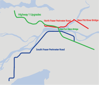
The Gateway Program is a C$3.0 billion regional transportation project for Metro Vancouver and surrounding areas that is being managed by the British Columbia Ministry of Transportation. The ministry introduced the Gateway Program on January 31, 2006, as a means to address growing congestion and reduce travel times. The bulk of the construction took place from 2006 to 2014 and saw the completion of the Golden Ears Bridge, the Pitt River Bridge, the Port Mann Bridge, improvements on the Sea-to-Sky highway, and finally the construction of the South Fraser Perimeter Road. The Greater Gateway Program is expected to finish by 2030.
An electoral redistribution was undertaken in 2008 in British Columbia in a process that began in late 2005 and was completed with the passage of the Electoral Districts Act, 2008 on April 10, 2008. The redistribution modified most electoral boundaries in the province and increased the number of MLAs from 79 to 85. The electoral boundaries created by the redistribution were first used in the 2009 provincial election.
An electoral redistribution in British Columbia was undertaken by the BC Electoral Boundaries Commission beginning in 2014 and was formalized by the passage of Bill 42, the 2015 Electoral Districts Act, during the 40th British Columbia Parliament. The act came into effect on November 17, 2015. The redistribution added two seats to the previous total, increasing the number of MLAs in the province from 85 to 87. The electoral boundaries came into effect for the 2017 election. The next redistribution is required to occur following the 2020 British Columbia general election.

The Cape Horn Interchange is a major interchange that connects British Columbia Highway 1 to Lougheed Highway, a heavily signalized thoroughfare in Coquitlam, Port Coquitlam, and Burnaby, and the Mary Hill Bypass, bypassing the Coquitlam and Port Coquitlam sections of Lougheed Highway and forming the quickest route to Pitt Meadows and Maple Ridge. It also includes several exits to United Boulevard, a light-industrial and commercial road in southern Coquitlam.
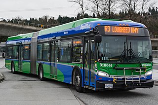
The R3 Lougheed Hwy is an express bus service with bus rapid transit elements in Metro Vancouver, British Columbia, Canada. Part of TransLink's RapidBus network, it travels along Lougheed Highway and connects Coquitlam, Port Coquitlam, Pitt Meadows, and Maple Ridge.