British Columbia Highway 7A

Last updated

BC-7A.svg

Highway 7A

Barnet Highway
Barnet Road
Hastings Street
St Johns Street
Inlet Drive
Route information
Maintained by British Columbia Ministry of Transportation and Infrastructure
Length25.9 km [1]  (16.1 mi)
Existed~1953–1999
Major junctions
West endBC-1A.svgBC-99.svgBC-99A.svg Hwy 1A  / Hwy 99  / Hwy 99A (Georgia Street) in Vancouver
Major intersectionsBC-1 (TCH).svg Hwy 1 (TCH) in Vancouver
East endBC-7.svg Hwy 7 in Coquitlam
Location
Country Canada
Province British Columbia
Major cities Vancouver
Burnaby
Port Moody
Coquitlam
Highway system
    BC-7.svg Hwy 7 BC-7B.svg Hwy 7B

    Highway 7A, known locally and on street signs as the Barnet Highway, Barnet Road,St. Johns Street, Inlet Drive and Hastings Street, was Highway 7's original 1941 route between the harbour in Vancouver and Port Moody. The highway gained the 7A designation around 1953 due to Highway 7 being re-designated along Lougheed Highway through Maillardville and Central Burnaby and was disestablished on April 1, 1999.

    Contents

    Route details

    The 26 km (16 mi) long Highway 7A largely followed a parallel route alongside the Canadian Pacific Railway. The highway started off in the west at Seymour Street in Downtown Vancouver, and went 8 km (5.0 mi) along Hastings Street, passing its junction with Highway 1 en route, until it reached Boundary Road, where the highway crossed into Burnaby. Highway 7A continued east along Hastings Street in Burnaby for 5 km (3.1 mi) before turning northeast via Inlet Drive onto Barnet Highway. Once Hastings Street terminates the road narrows from 6 lanes to four, and the speed limit is upped from 50 to 80 km/h (from 31 to 50 mph). Barnet Highway carried Highway 7A on a winding 9 km (5.6 mi) long route on the south shore of Burrard Inlet through Burnaby and into Port Moody, where it meets an intersection with St. John's Street. Highway 7A then travelled 5 km (3.1 mi) east along St. Johns Street to its junctions with Dewdney Trunk Road and Ioco Road, after which it bears the street name Barnet Highway again, before terminating at its junction with Highway 7 in Coquitlam.

    History

    Historically speaking, the route that Highway 7A took consisted of three distinct roads: the Dewdney Trunk Road, the Barnet Highway and Hastings Street. All of these roads have existed for well over a century. Dewdney Trunk road was once the principal route for traffic north of the Fraser and Hastings Street had been established early on in the history of Vancouver and Burnaby as municipalities. Both Barnet and Dewdney were completed around the turn of the 20th century [2] [3] [4]

    In 1941, a province-wide highway numbering scheme came into effect, [5] with Hastings, Barnet, St. Johns and Dewdney Trunk becoming part of Highway 7. [6] In 1952, Dewdney Trunk lost its highway designation as a new segment of Highway 7 from Shaughnessy Street to today's intersection of St. Johns and Dewdney Trunk Road was completed. This included the building of a new overhead crossing the Canadian Pacific Railway tracks. [7] [8]

    At some point in the early 1950s (possibly 1953) Highway 7 was rerouted to the newer Lougheed Highway through Maillardville and Central Burnaby. This finally gave Hastings, Barnet Highway and St. Johns Street the Highway 7A designation. During the mid-50s multiple improvements were made along the Barnet Highway section. [9] In 1959, a study conducted by the Technical Committee for Metropolitan Highway Planning suggested the building of a series freeways throughout Vancouver. The committee looked at the possibility of a freeway over Burnaby Mountain which would be a bypass the Barnet over Burnaby Mountain, but ultimately rejected it. [10] Different proposals called for a freeway bypass of Port Moody, a freeway through the Coquitlam Chines and others. None of these plans ever came to fruition. [9]

    Barnet Highway remained a two lane highway until the 1990s, when the province began to recognize that congestion was starting to build throughout the overall length of highway 7A. Using the concept of HOV lanes as a means to lessen single occupancy vehicle use and reduce said congestion, the province began to design the Barnet/Hastings People-Mover Project. The project started in 1991 and saw various layouts be considered. However, it was ultimately decided that Hastings would be widened to six lanes and the Barnet highway be finally upgraded into a four-lane facility. The right hand lanes in each direction along the two segments would operate as HOV lanes from 6:00 AM to 8:30 AM towards Vancouver and from 3:30 PM to 6:00 PM towards Port Moody. The improvement also saw the addition of an HOV lane going westbound on St. Johns Street and Clarke St. in Port Moody. [11] The project was completed on September 4, 1996, at a cost of $105 million (equivalent to $161,811,024 in 2020). [12] Counterintuitively, the project led to an increase in travel times on certain stretches of the route. [13]

    As part of the creation of TransLink, a major road network was to be created and maintained. The province had also decided to handover hundreds of kilometres of roadways to municipalities throughout the province. [14] [15] [16] Highway 7A's component routes were a part of the handover, and so on the April 1, 1999, Highway 7A ceased to be. [17] [18] [19]

    The Burnaby section of this road has been renamed to Barnet Road.

    Major intersections

    The entire route is in Metro Vancouver Regional District.

    Locationkm [1] miDestinationsNotes
    Vancouver 0.00.0BC-99.svgOntario M502.svg Howe Street, Seymour Street (Hwy 99 south) Airport, Canada–United States border
    BC-99.svg Georgia Street (Hwy 99 north) Whistler
    Former western terminus; Hwy 7A followed Howe Street and Seymour Street (one-way pair) north; former Hwy 1A  / Hwy 99A south
    0.50.31 Hastings Street Hwy 7A followed Hastings Street
    0.60.37 Granville Street Granville Mall (transit only) south of Hastings Street; near Translinkcanada.svg Translinkexpo.svg Translinkseabus.svg Translinkwce.svg   Waterfront station
    1.10.68 Cambie Street
    1.81.1 Main Street
    3.42.1 Clark Drive
    3.92.4 Commercial Drive
    6.74.2BC-1 (TCH).svg Hwy 1 (TCH) (Cassiar Connector) Hope, Whistler Hwy 1 passes underneath Hastings Street via the Cassiar Tunnel; Hwy 1 exit 26
    Burnaby 12.88.0 Hastings Street (to Burnaby Mountain Parkway) Simon Fraser University Renamed "Barnet Road"
    Port Moody 23.514.6 Dewdney Trunk Road
    Coquitlam 25.916.1BC-7.svg Hwy 7 (Lougheed Highway) / Pinetree Way Port Coquitlam Former eastern terminus; continues as Hwy 7 east
    1.000 mi = 1.609 km; 1.000 km = 0.621 mi

    Related Research Articles

    <span class="mw-page-title-main">Burnaby</span> City in British Columbia, Canada

    Burnaby is a city in the Lower Mainland region of British Columbia, Canada. Located in the centre of the Burrard Peninsula, it neighbours the City of Vancouver to the west, the District of North Vancouver across the confluence of the Burrard Inlet with its Indian Arm to the north, Port Moody and Coquitlam to the east, New Westminster and Surrey across the Fraser River to the southeast, and Richmond on the Lulu Island to the southwest.

    Highway 1 is a provincial highway in British Columbia, Canada, that carries the main route of the Trans-Canada Highway (TCH). The highway is 1,047 kilometres (651 mi) long and connects Vancouver Island, the Greater Vancouver region in the Lower Mainland, and the Interior. It is the westernmost portion of the main TCH to be numbered "Highway 1", which continues through Western Canada and extends to the Manitoba–Ontario boundary. The section of Highway 1 in the Lower Mainland is the second-busiest freeway in Canada, after Ontario Highway 401 in Toronto.

    Highway 7, known for most of its length as the Lougheed Highway and Broadway, is an alternative route to Highway 1 through the Lower Mainland region of British Columbia. Whereas the controlled-access Highway 1 follows the southern bank of the Fraser River, Highway 7 follows the northern bank.

    There are many roads in the southwestern part of British Columbia and Vancouver Island that were designated as Highway 1A. These roads were sections of the original 1941 route of Highway 1 before its various re-alignments, and are used today as service routes and frontage roads. The "B.C. Highway 1A" designations were removed from these sections by the province between 2005 and 2010, although signage remains along some of the route and the designation on some maps.

    <span class="mw-page-title-main">British Columbia Highway 13</span>

    Highway 13 is an 11.5 km (7.1 mi) long two-lane route through the eastern part of Langley, British Columbia. Highway 13 connects Washington state to the central Fraser Valley.

    Highway 11, known locally as the Abbotsford-Mission Highway, is a 17 km (11 mi) long at-grade expressway that figuratively cuts the Fraser Valley in half. The highway was first given the '11' designation in 1958, and it originally followed South Fraser Way through Abbotsford, being re-routed onto the four-lane Sumas Way in the mid-1980s. Highway 11 originally entered Mission over the same bridge that carries a spur of the Canadian Pacific Railway across the Fraser River, but it was re-routed onto its own bridge, the Mission Bridge, in 1973.

    <span class="mw-page-title-main">Port Mann Bridge</span> Bridge over the Fraser River in Metro Vancouver, British Columbia; opened in 2012

    The Port Mann Bridge is a 10-lane cable-stayed bridge, 90 km/h speed limit, in British Columbia, Canada, that opened to traffic in 2012. It carries 10 lanes of traffic with space reserved for a light rail line.

    <span class="mw-page-title-main">Pitt River Bridge</span> Bridge in Port Coquitlam, Pitt Meadows

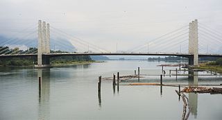
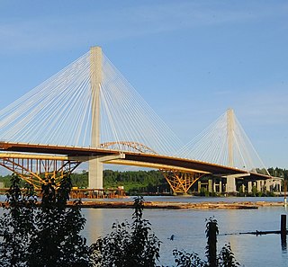
    The Pitt River Bridge is a cable-stayed bridge that spans the Pitt River between Port Coquitlam and Pitt Meadows in British Columbia, Canada. The bridge is part of Highway 7, carrying Lougheed Highway across the river. The current bridge opened on October 4, 2009. The bridge includes a 380 m cable stay bridge structure, 126 m of multi-span approaches, a 50 m interchange structure and approximately 2 km of grade construction. Total project cost for the bridge was $200 million

    <span class="mw-page-title-main">Kingsway (Vancouver)</span> Major road in British Columbia

    Kingsway is a major thoroughfare that crosses through the Canadian cities of Vancouver and Burnaby, British Columbia. The road runs diagonally from northwest to southeast, emerging from Vancouver's Main Street just south of East 7th Avenue and becoming 12th Street at the Burnaby–New Westminster border.

    <span class="mw-page-title-main">Cassiar Tunnel</span> Highway traffic tunnel on the Trans-Canada Highway in Vancouver, British Columbia

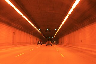
    The Cassiar Connector is a highway traffic tunnel on the Trans-Canada Highway. It is located in the north-east corner of Vancouver, British Columbia, near the Vancouver-Burnaby border. Travelling northward, the tunnel begins under Adanac Street and passes under the interchange between East Hastings Street and the Highway 1 offramps. It ends underneath Triumph Street, with the highway continuing north to the McGill Street interchange and the Ironworkers Memorial Second Narrows Crossing towards the District of North Vancouver. The tunnel is 730 metres (2,400 ft) long. Dangerous goods are not permitted to be transported through the tunnel.

    <span class="mw-page-title-main">Evergreen Extension</span> 2016 extension of Metro Vancouvers SkyTrain Millennium Line

    The Evergreen Extension is a 10.9-kilometre-long (6.8 mi) extension of the Millennium Line of Metro Vancouver's SkyTrain rapid transit system. The extension runs from Lougheed Town Centre in Burnaby to Lafarge Lake–Douglas in Coquitlam and included six new SkyTrain stations and an upgraded existing station on the Millennium Line. It began operations on December 2, 2016.

    <span class="mw-page-title-main">99 B-Line</span> Express bus service in Metro Vancouver, Canada

    The 99 B-Line is an express bus line with bus rapid transit elements in Metro Vancouver, British Columbia, Canada. It travels along Broadway, a major east–west thoroughfare, and connects the University of British Columbia (UBC) to Commercial–Broadway station on the SkyTrain system. It is operated by Coast Mountain Bus Company and funded by TransLink.

    <span class="mw-page-title-main">97 B-Line</span> Former express bus service in Metro Vancouver, Canada

    The 97 B-Line was an express bus line in Metro Vancouver, British Columbia, Canada. It connected Coquitlam Central station on the West Coast Express system to Lougheed Town Centre station on the SkyTrain system. It was operated by Coast Mountain Bus Company and funded by TransLink. Going west, the route went along Clarke Rd., St. John's St., Ioco Rd, Guildford Way and Pinetree Way, and served Burnaby, Port Moody, and Coquitlam. The 97 B-Line was discontinued on December 18, 2016, as part of the December 2016 TransLink seasonal bus service changes, many resulting from the opening of the Evergreen Extension of the Millennium Line. The line carried 10,750 passengers on weekdays in 2011.

    <span class="mw-page-title-main">Tri-Cities (British Columbia)</span> Geographical grouping in Metro Vancouver

    The Tri-Cities are an informal grouping of the three adjacent suburban cities of Coquitlam, Port Coquitlam, and Port Moody, along with the two villages of Anmore and Belcarra in the northeast sector of Metro Vancouver in British Columbia. Combined, these five communities have a 2016 population of 234,300 residents:

    <span class="mw-page-title-main">North Burnaby</span>

    North Burnaby is a general name for a large neighbourhood in the City of Burnaby, British Columbia, that includes a number of smaller ones. It stretches from Boundary Road in the west to Burnaby Mountain with Simon Fraser University in the east and is bounded by Burrard Inlet to the north and the Lougheed Highway to the south. It is a desirable place to live for many local and immigrant families, which is reflected by real-estate prices that keep climbing and have doubled in the last 15 years.

    <span class="mw-page-title-main">Hastings Street (Vancouver)</span>

    Hastings Street is one of the most important east-west traffic corridors in the cities of Vancouver and Burnaby, British Columbia, Canada, and used to be a part of the decommissioned Highway 7A. In the central business district of Downtown Vancouver, it is known as West Hastings Street; at Carrall Street it becomes East Hastings Street and runs eastwards through East Vancouver and Burnaby. In Burnaby, there is no east-west designation. The street ends in Westridge, a neighbourhood at the foot of Burnaby Mountain where it joins the recently built Burnaby Mountain Parkway and diverges from the continuation of the former Highway 7A as the Barnet Highway, to Port Moody, British Columbia.

    <span class="mw-page-title-main">Gateway Program (Vancouver)</span> Regional transportation project

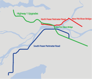
    The Gateway Program is a C$3.0 billion regional transportation project for Metro Vancouver and surrounding areas that is being managed by the British Columbia Ministry of Transportation. The ministry introduced the Gateway Program on January 31, 2006, as a means to address growing congestion and reduce travel times. The bulk of the construction took place from 2006 to 2014 and saw the completion of the Golden Ears Bridge, the Pitt River Bridge, the Port Mann Bridge, improvements on the Sea-to-Sky highway, and finally the construction of the South Fraser Perimeter Road. The Greater Gateway Program is expected to finish by 2030.

    The Dewdney Trunk Road was one of the earliest major roads in the Fraser Valley of British Columbia, Canada. Originally running from Port Moody to Dewdney, just east of Mission, it exists in three sections today:

    British Columbia Highway 25, also known as the Terrace–Kitimat Highway, was a 59 km (37 mi) long spur of the Yellowhead Highway in the Regional District of Kitimat-Stikine. First opened on 28 September 1957 at a cost of $3.5 million, it provides a connection from Terrace, on Highway 16, south to Kitimat. It received the number 25 in 1964. In 1986, Highway 25 was renumbered and absorbed by Highway 37. As part of the renumbering, Highway 37 follows a 91 km (57 mi) concurrency with Highway 16 between Kitwanga, the former southern terminus of Highway 37, and Terrace.

    References

    1. 1 2 Google (September 16, 2021). "British Columbia Highway 7A" (Map). Google Maps . Google. Retrieved September 16, 2021.
    2. Government of British Columbia (1905). ESTIMATE OF REVENUE AND RECEIPTS OF THE PROVINCE OF BRITISH COLUMBIA, FOR THE Financial Year ending 30th June, 1905 (Report). British Columbia Queen's Printer. p. 32. J110.L5 S7; 1904_05_D1_D33. Retrieved January 30, 2022.
    3. Government of British Columbia (1904). REPORT OF THE CHIEF COMMISSIONER OF LANDS AND WORKS OF THE PROVINCE OF BRITISH COLUMBIA FOR THE FISCAL YEAR ENDING 30TH JUNE, 1903 (Report). British Columbia Queen's Printer. pp. 30, 36. J110.L5 S7; 1904_06_E1_E148. Retrieved January 30, 2022.
    4. Government of British Columbia (1904). 1902-1903 (NO.1). SUPPLEMENTARY ESTIMATES OF EXPENDITURE OF THE PROVINCE OF BRITISH COLUMBIA, FOR THE FISCAL YEAR ENDING 30TH JUNE, 1903 (Report). British Columbia Queen's Printer. p. 2. J110.L5 S7; 1902_56_1439_1440. Retrieved January 30, 2022.
    5. British Columbia Department of Public Works (September 12, 1941). Report of the Minister of Public Works for the Fiscal Year 1939/1940 (Report). Victoria: Government of British Columbia. doi:10.14288/1.0314091. J110.L5 S7; 1940_V02_04_P1_P125. Retrieved November 23, 2021.
    6. Shell Oil Company (1951). "Shell Street Map of Vancouver. 10-Y-1951-1." (Map). Shell Map of Vancouver and Victoria, B.C. (Vancouver side). 1:50688. 183. Shell Oil Company.
    7. British Columbia Ministry of Public Works (1953). Report of the Minister of Public Works for the Fiscal Year 1951-52 (Report). Victoria: Government of British Columbia. pp. 38, 205. doi:10.14288/1.0348086. J110.L5 S7; 1953_V02_06_P1_P214. Retrieved January 30, 2022.
    8. "Lougheed Bridge Opens in January". The Vancouver Daily Province. December 20, 1951. p. 38. ProQuest   2368933933.
    9. 1 2 Elder, Brian W. (1992). Land use and transportation planning: The Greater Vancouver Regional District North East Sector: 1951- 1990 (Thesis). University of British Columbia. doi:10.14288/1.0098810.
    10. Technical Committee for Metropolitan Highway Planning (March 13, 1959). A Study on Highway Planning for Metropolitan Vancouver - British Columbia - Freeways with Rapid Transit (Report). Vol. 2.
    11. Delcan Corp (March 1994). Barnet/Hastings People-Moving Project (Report). Vol. I–V. B.C. Ministry of Transportation and Highways.
    12. Government of British Columbia (September 4, 1996). "MAJOR PROJECT TURNS BARNET/HASTINGS INTO PEOPLE-MOVING EXPRESS ROUTE". Vancouver. Retrieved January 30, 2022.
    13. Bracewell, Dale J. (1998). High occupancy vehicle monitoring and evaluation framework (Thesis). doi:10.14288/1.0063791.
    14. Government of British Columbia (December 22, 1996). "PROVINCE TO MAINTAIN ARTERIAL ROADS UNTIL APRIL". Vancouver. Retrieved January 30, 2022.
    15. Government of British Columbia (January 23, 1997). "DEVOLUTION OF ARTERIAL HIGHWAYS DEFERRED TO 1998". Vancouver. Retrieved January 30, 2022.
    16. Government of British Columbia (June 19, 1998). "GROUNDBREAKING ACT TO IMPROVE TRANSPORTATION SERVICES IN GREATER VANCOUVER - MACPHAIL". Vancouver. Retrieved January 30, 2022.
    17. "Transportation Act, RSBC 1996". Article Part 4, Div. 6, Section 56 (1)(C), Act of 2022.
    18. "South Coast Transportation Authority Act, RSBC 1996". Article Part 2, Section 18, Act of 1996.
    19. "Greater Vancouver Regional Transportation Authority Major Road Network Bylaw No. 1, 1998.". of March 20, 1998 (PDF).
    Template:Attached KML/British Columbia Highway 7A
    KML is not from Wikidata