
Bowen Island, British Columbia, is an island municipality that is part of Metro Vancouver. Bowen Island is within the jurisdiction of the Islands Trust. Located in Howe Sound, it is approximately 6 kilometres (3.7 mi) wide by 12 kilometres (7.5 mi) long, with the island at its closest point about 3 kilometres (1.9 mi) west of the mainland. There is regular ferry service from Horseshoe Bay provided by BC Ferries, as well as semi-regular water taxi services. The population of 4,256 is supplemented in the summer by roughly 1,500 visitors, as Bowen Island regularly receives travelers in the summer season. The island has a land area of 50.12 km2 (19.35 sq mi).
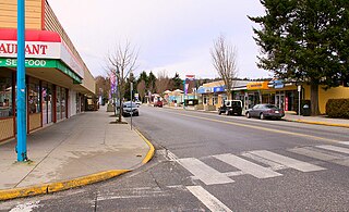
Gibsons is a coastal community of 4,605 in southwestern British Columbia, Canada on the Strait of Georgia.
Highway 99, also known as the Fraser Delta Thruway south of Vancouver, and the Sea to Sky Highway, Squamish Highway, or Whistler Highway north of Vancouver, is the major north–south artery running through the Greater Vancouver area of British Columbia from the U.S. border, up Howe Sound through the Sea to Sky Country to Lillooet, and connecting to Highway 97 just north of Cache Creek. The highway's number was derived from the former U.S. Route 99, with which the highway originally connected to at the border. The highway currently connects with Interstate 5 at the United States border.

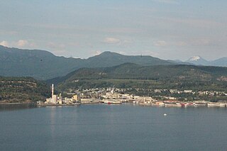
Powell River is a city on the northern Sunshine Coast of southwestern British Columbia, Canada. Most of its population lives near the eastern shores of Malaspina Strait, which is part of the larger Georgia Strait between Vancouver Island and the Mainland. With two intervening long, steep-sided fjords inhibiting the construction of a contiguous road connection with Vancouver to the south, geographical surroundings explain Powell River's remoteness as a community, despite relative proximity to Vancouver and other populous areas of the BC Coast. The city is the location of the head office of the qathet Regional District.
The Sunshine Coast is a geographic subregion of the British Columbia Coast that generally comprises the regional districts of qathet and Sunshine Coast.
The qathet Regional District is a regional district in the Canadian province of British Columbia. Its only incorporated municipality is the City of Powell River, although it includes a number of unincorporated areas. The district encompasses a land area of 5,075.33 square kilometres (1,959.60 sq mi). The district was formerly known as the Powell River Regional District. Because of frequent confusion between the identical names of Powell River district and city, the district's name was changed in 2018 to qathet, from q̓at̓ᶿət, meaning "working together, bringing together" in the Comox language of the Tla'amin Nation.

The Sunshine Coast Regional District is a regional district in British Columbia, Canada. It is located on the southern mainland coast, across Georgia Strait from Vancouver Island. It borders on the qathet Regional District to the north, the Squamish-Lillooet Regional District to the east, and, across Howe Sound, the Metro Vancouver District to the south. The regional district offices are located in the District Municipality of Sechelt.
Sechelt is a district municipality located on the lower Sunshine Coast of British Columbia. Approximately 50 km northwest of Vancouver, it is accessible from mainland British Columbia by a 40-minute ferry trip between Horseshoe Bay and Langdale, and a 25-minute drive from Langdale along Highway 101, also known as the Sunshine Coast Highway. The name Sechelt is derived from the Sechelt language word, shishalh, the name of the First Nations people who first settled the area thousands of years ago.
BC Ferries operates three Intermediate-class ferries:

Earls Cove is a small settlement located on Jervis Inlet in the Sunshine Coast region of British Columbia. It is a terminal for the BC Ferries route across the inlet to Saltery Bay, linking the Lower Sunshine Coast with the Upper Sunshine Coast. Earls Cove is at the north end of the Sechelt Peninsula and on the east side of the mouth of Jervis Inlet, adjacent to Agamemnon Channel, across which is Nelson Island.
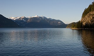
Howe Sound is a roughly triangular sound, that joins a network of fjords situated immediately northwest of Vancouver, British Columbia.

Jervis Inlet is one of the principal inlets of the British Columbia Coast, about 95 km (59 mi) northwest of Vancouver, and the third of such inlets north of the 49th parallel, the first of which is Burrard Inlet, Vancouver's harbour.

Langdale is a small community on the Sunshine Coast of southern British Columbia, Canada. It is set in a verdant environment characteristic of many small BC communities. It plays host to a ferry terminal of the same name, which serves as the point of entry for most vehicles entering the Sunshine Coast region. Langdale is part of West Howe Sound, Electoral Area F within the Sunshine Coast Regional District (SCRD) in British Columbia, Canada.

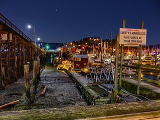
Keats Island is an inhabited island located in Howe Sound near Vancouver, British Columbia. Around eighty people live on Keats Island year-round.

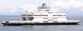
MV Malaspina Sky is an Intermediate-class ferry in the BC Ferries fleet built in 2008.
The Sechelt Peninsula is located on the Sunshine Coast of British Columbia, just northwest of Vancouver. It is bounded to the west by Malaspina Strait, to the north by Agamemnon Channel and Jervis Inlet, to the east by Sechelt Inlet, and to the south by the Strait of Georgia (separating it from Vancouver Island. Its approximately 350 km2 is a mixture of drier and wetter temperate rain forest. The Caren Range extends north–south along the shore of Sechelt Inlet. The peninsula is a popular outdoor recreation destination, containing many lakes and opportunities for shoreline and woodland hiking, including to the renowned Skookumchuk Narrows. There are several parks, the largest of which is Spipiyus Provincial Park in the interior of the peninsula.
The BC Bike Race is a seven-day mountain bike stage race held in British Columbia, Canada, traditionally held in early July. Six hundred racers ride an average of 50 kilometres a day on race routes that are 75% singletrack.

M/V Queen of the Islands was a RORO ferry operated by BC Ferries between 1963 and 1991. Although the passenger areas provided for an enjoyable travel experience for the general public, she was much maligned by the crews that worked on her, and the Queen of the Islands quickly garnered a reputation as being one of the most unloved ships ever to have operated with BC Ferries.
West Howe Sound, British Columbia is also known as Sunshine Coast Regional District (SCRD) Electoral Area F on the Sunshine Coast of British Columbia, Canada. It is bound on the south by the Town of Gibsons, on the west by Elphinstone SCRD Electoral Area E, on the east by Howe Sound, on the north by Squamish-Lillooet Regional District Electoral Area D, and on the southeast by Metro Vancouver Regional District Electoral Area A.

Saltery Bay is an unincorporated community on the Sunshine Coast of southern British Columbia, Canada. It is located about 30 kilometres (19 mi) southeast of the city of Powell River. It is adjacent to Saltery Bay Provincial Park.


